Big Horn County, Wyoming
| Big Horn County, Wyoming | ||
|---|---|---|
 | ||
| ||
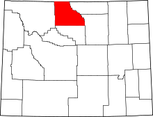 Location in the U.S. state of Wyoming | ||
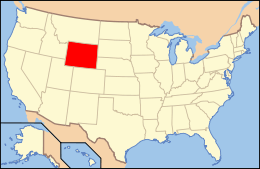 Wyoming's location in the U.S. | ||
| Founded | 1897 | |
| Seat | Basin | |
| Largest town | Lovell | |
| Area | ||
| • Total | 3,159 sq mi (8,182 km2) | |
| • Land | 3,137 sq mi (8,125 km2) | |
| • Water | 22 sq mi (57 km2), 0.7% | |
| Population (est.) | ||
| • (2016) | 12,005 | |
| • Density | 3.7/sq mi (1.4/km2) | |
| Congressional district | At-large | |
| Time zone | Mountain: UTC−7/−6 | |
| Website |
www | |
Big Horn County is a county located in the U.S. state of Wyoming. As of the 2010 census, the population was 11,668.[1] The county seat is Basin.[2] It is south from the Montana state line.
History
Big Horn County was created by the legislature of Wyoming Territory on March 12, 1890 and organized in 1897. The county was created with lands ceded by Fremont County, Johnson County, and Sheridan County.[3]
Big Horn County was named for the Big Horn Mountains which form its eastern boundary.[4] Originally, the county included the entire Big Horn Basin.
In 1909, Park County, was detached from Big Horn County. In 1911, Hot Springs County, and Washakie County were detached from Big Horn County. At that point in time, the county got its present borders.
The current sheriff of Big Horn County is Ken Blackburn.
Geography
According to the U.S. Census Bureau, the county has a total area of 3,159 square miles (8,180 km2), of which 3,137 square miles (8,120 km2) is land and 22 square miles (57 km2) (0.7%) is water.[5]
Adjacent counties
- Park County, Wyoming - west
- Washakie County, Wyoming - south
- Johnson County, Wyoming - east
- Sheridan County, Wyoming - east
- Big Horn County, Montana - north
- Carbon County, Montana - north
Big Horn County in Wyoming and Montana are one of ten pairs of counties and parishes in the United States with the same name to border each other across state lines. The others are Sabine (Texas and Louisiana), Union (Arkansas and Louisiana), Bristol (Massachusetts and Rhode Island), Kent (Maryland and Delaware), Escambia (Alabama and Florida), Pike (Illinois and Missouri), Teton (Idaho and Wyoming), Park (Montana and Wyoming), and San Juan (New Mexico and Utah - albeit through a single point, the four corners).
Major highways
National protected areas
Demographics
| Historical population | |||
|---|---|---|---|
| Census | Pop. | %± | |
| 1900 | 4,328 | — | |
| 1910 | 8,886 | 105.3% | |
| 1920 | 12,105 | 36.2% | |
| 1930 | 11,222 | −7.3% | |
| 1940 | 12,911 | 15.1% | |
| 1950 | 13,176 | 2.1% | |
| 1960 | 11,898 | −9.7% | |
| 1970 | 10,202 | −14.3% | |
| 1980 | 11,896 | 16.6% | |
| 1990 | 10,525 | −11.5% | |
| 2000 | 11,461 | 8.9% | |
| 2010 | 11,668 | 1.8% | |
| Est. 2016 | 12,005 | [6] | 2.9% |
| U.S. Decennial Census[7] 1870–2000[8] 2010–2016[1] | |||
2000 census
As of the census[9] of 2000, there were 11,461 people, 4,312 households, and 3,087 families residing in the county. The population density was 4 people per square mile (1/km²). There were 5,105 housing units at an average density of 2 per square mile (1/km²). The racial makeup of the county was 94.03% White, 0.11% Black or African American, 0.75% Native American, 0.21% Asian, 0.07% Pacific Islander, 3.37% from other races, and 1.46% from two or more races. 6.17% of the population were Hispanic or Latino of any race. 23.0% were of German, 21.4% English, 8.1% American and 8.0% Irish ancestry.
There were 4,312 households out of which 32.50% had children under the age of 18 living with them, 61.00% were married couples living together, 6.80% had a female householder with no husband present, and 28.40% were non-families. 25.00% of all households were made up of individuals and 11.90% had someone living alone who was 65 years of age or older. The average household size was 2.60 and the average family size was 3.13.
In the county, the population was spread out with 28.70% under the age of 18, 7.30% from 18 to 24, 22.60% from 25 to 44, 24.60% from 45 to 64, and 16.80% who were 65 years of age or older. The median age was 39 years. For every 100 females there were 100.20 males. For every 100 females age 18 and over, there were 97.10 males.
The median income for a household in the county was $32,682, and the median income for a family was $38,237. Males had a median income of $30,843 versus $19,489 for females. The per capita income for the county was $15,086. About 10.20% of families and 14.10% of the population were below the poverty line, including 19.20% of those under age 18 and 10.00% of those age 65 or over.
2010 census
As of the 2010 United States Census, there were 11,668 people, 4,561 households, and 3,179 families residing in the county.[10] The population density was 3.7 inhabitants per square mile (1.4/km2). There were 5,379 housing units at an average density of 1.7 per square mile (0.66/km2).[11] The racial makeup of the county was 94.4% white, 0.9% American Indian, 0.3% Asian, 0.2% black or African American, 3.0% from other races, and 1.2% from two or more races. Those of Hispanic or Latino origin made up 8.4% of the population.[10] In terms of ancestry, 30.0% were German, 22.3% were English, 10.4% were Irish, 7.6% were Scottish, and 5.7% were American.[12]
Of the 4,561 households, 31.0% had children under the age of 18 living with them, 58.2% were married couples living together, 7.6% had a female householder with no husband present, 30.3% were non-families, and 26.2% of all households were made up of individuals. The average household size was 2.52 and the average family size was 3.05. The median age was 41.8 years.[10]
The median income for a household in the county was $48,270 and the median income for a family was $57,705. Males had a median income of $40,762 versus $31,440 for females. The per capita income for the county was $24,486. About 5.7% of families and 8.9% of the population were below the poverty line, including 11.2% of those under age 18 and 7.1% of those age 65 or over.[13]
Government and infrastructure
The Wyoming Department of Health Wyoming Retirement Center, a nursing home,[14] is located in Basin.[15][16] The facility was operated by the Wyoming Board of Charities and Reform until that agency was dissolved as a result of a state constitutional amendment passed in November 1990.[17]
| Year | Republican | Democratic | Third parties |
|---|---|---|---|
| 2016 | 76.5% 4,067 | 11.4% 604 | 12.2% 646 |
| 2012 | 80.5% 4,285 | 16.3% 868 | 3.2% 171 |
| 2008 | 76.2% 4,045 | 20.9% 1,108 | 3.0% 157 |
| 2004 | 80.1% 4,232 | 18.2% 960 | 1.7% 91 |
| 2000 | 75.6% 3,720 | 20.4% 1,004 | 3.9% 194 |
| 1996 | 58.3% 2,821 | 29.7% 1,438 | 12.0% 580 |
| 1992 | 46.5% 2,216 | 25.5% 1,216 | 27.9% 1,330 |
| 1988 | 68.2% 3,258 | 30.7% 1,469 | 1.1% 53 |
| 1984 | 76.5% 4,019 | 22.4% 1,175 | 1.1% 59 |
| 1980 | 71.0% 3,709 | 23.2% 1,212 | 5.8% 302 |
| 1976 | 65.7% 3,117 | 34.1% 1,618 | 0.3% 12 |
| 1972 | 75.4% 3,244 | 24.4% 1,049 | 0.2% 7 |
| 1968 | 64.1% 2,771 | 27.8% 1,201 | 8.2% 353 |
| 1964 | 49.8% 2,668 | 50.2% 2,690 | |
| 1960 | 62.8% 3,449 | 37.2% 2,044 | |
| 1956 | 65.0% 3,369 | 35.0% 1,813 | |
| 1952 | 68.7% 3,859 | 31.2% 1,755 | 0.1% 6 |
| 1948 | 50.4% 2,429 | 49.1% 2,370 | 0.5% 24 |
| 1944 | 53.5% 2,659 | 46.5% 2,314 | |
| 1940 | 52.2% 2,859 | 47.4% 2,594 | 0.4% 22 |
| 1936 | 38.1% 1,996 | 60.3% 3,156 | 1.6% 84 |
| 1932 | 51.2% 2,334 | 47.2% 2,155 | 1.6% 74 |
| 1928 | 73.6% 2,646 | 26.0% 933 | 0.5% 17 |
| 1924 | 54.5% 2,023 | 12.4% 459 | 33.2% 1,233 |
| 1920 | 65.8% 2,157 | 33.0% 1,082 | 1.2% 39 |
| 1916 | 44.8% 1,239 | 53.9% 1,493 | 1.3% 37 |
| 1912 | 35.4% 794 | 30.8% 691 | 33.7% 756 |
| 1908 | 60.3% 2,638 | 37.7% 1,648 | 2.1% 90 |
| 1904 | 70.8% 1,962 | 27.1% 751 | 2.1% 57 |
| 1900 | 63.8% 843 | 36.2% 479 | |
| 1896 | 47.0% 538 | 51.6% 591 | 1.5% 17 |
Education
Big Horn County has 4 public school districts:[19]
Communities
Towns
Census-designated places
Unincorporated communities
See also
References
- 1 2 "State & County QuickFacts". United States Census Bureau. Retrieved January 25, 2014.
- ↑ "Find a County". National Association of Counties. Archived from the original on May 31, 2011. Retrieved 2011-06-07.
- ↑ Long, John H., ed. (2004). "Wyoming: Individual County Chronologies". Wyoming Atlas of Historical County Boundaries. The Newberry Library. Retrieved August 19, 2015.
- ↑ Urbanek, Mae (1988). Wyoming Place Names. Missoula, MT: Mountain Press Publishing Company. ISBN 0-87842-204-8.
- ↑ "2010 Census Gazetteer Files". United States Census Bureau. August 22, 2012. Retrieved August 5, 2015.
- ↑ "Population and Housing Unit Estimates". Retrieved June 9, 2017.
- ↑ "U.S. Decennial Census". United States Census Bureau. Archived from the original on May 12, 2015. Retrieved August 5, 2015.
- ↑ "Historical Decennial Census Population for Wyoming Counties, Cities, and Towns". Wyoming Department of Administration & Information, Division of Economic Analysis. Retrieved January 25, 2014.
- ↑ "American FactFinder". United States Census Bureau. Archived from the original on 2013-09-11. Retrieved 2011-05-14.
- 1 2 3 "DP-1 Profile of General Population and Housing Characteristics: 2010 Demographic Profile Data". United States Census Bureau. Retrieved 2016-01-12.
- ↑ "Population, Housing Units, Area, and Density: 2010 - County". United States Census Bureau. Retrieved 2016-01-12.
- ↑ "DP02 SELECTED SOCIAL CHARACTERISTICS IN THE UNITED STATES – 2006-2010 American Community Survey 5-Year Estimates". United States Census Bureau. Retrieved 2016-01-12.
- ↑ "DP03 SELECTED ECONOMIC CHARACTERISTICS – 2006-2010 American Community Survey 5-Year Estimates". United States Census Bureau. Retrieved 2016-01-12.
- ↑ "WDH Who We Are - Wyoming Retirement Center Archived 2007-06-27 at the Wayback Machine.." Wyoming Department of Health. Retrieved on December 12, 2010.
- ↑ "WDH Directory." Wyoming Department of Health. Retrieved on December 12, 2010. "890 Highway 20, Basin WY 82410 Fax (307) 568-3887" (Retirement Center)
- ↑ "Basin town, Wyoming." U.S. Census Bureau. Retrieved on December 12, 2010.
- ↑ "About the Department of Corrections." Wyoming Department of Corrections. Retrieved on August 22, 2010.
- ↑ Leip, David. "Dave Leip's Atlas of U.S. Presidential Elections". uselectionatlas.org. Retrieved 2018-04-05.
- ↑ Wyoming Department of Education School Calendar 2007-2008 Archived 2008-02-11 at the Wayback Machine., retrieved 2008-05-08
External links
| Wikimedia Commons has media related to Big Horn County, Wyoming. |
Places adjacent to Big Horn County, Wyoming | ||||||||||
|---|---|---|---|---|---|---|---|---|---|---|
| ||||||||||
Municipalities and communities of Big Horn County, Wyoming, United States | ||
|---|---|---|
| Towns | | |
| CDPs | ||
| Unincorporated communities | ||
| Footnotes | ‡This populated place also has portions in an adjacent county or counties | |