Antora Peak
| Antora Peak | |
|---|---|
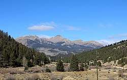 Antora Peak (center) and other peaks in the Sawatch Range. | |
| Highest point | |
| Elevation | 13,275 ft (4,046 m) [1][2] |
| Prominence | 2,409 ft (734 m) [2] |
| Isolation | 6.75 mi (10.86 km) [2] |
| Listing | |
| Coordinates | 38°19′30″N 106°13′05″W / 38.3249994°N 106.2180786°WCoordinates: 38°19′30″N 106°13′05″W / 38.3249994°N 106.2180786°W [3] |
| Geography | |
 Antora Peak | |
| Location | Saguache County, Colorado, U.S.[3] |
| Parent range | Sawatch Range[2] |
| Topo map |
USGS 7.5' topographic map Bonanza, Colorado[3] |
Antora Peak is a high and prominent mountain summit in the southern Sawatch Range of the Rocky Mountains of North America. The 13,275-foot (4,046 m) thirteener is located in Rio Grande National Forest, 4.6 miles (7.4 km) west-northwest (bearing 295°) of the Town of Bonanza in Saguache County, Colorado, United States.[1][2][3]
Historical names
- Antora Mountain
- Antora Peak – 1972 [3]
- Antero Mountain
- Antero Peak
See also
References
- 1 2 The elevation of Antora Peak includes an adjustment of +1.883 m (+6.18 ft) from NGVD 29 to NAVD 88.
- 1 2 3 4 5 "Antora Peak, Colorado". Peakbagger.com. Retrieved October 19, 2014.
- 1 2 3 4 5 "Antora Peak". Geographic Names Information System. United States Geological Survey. Retrieved October 19, 2014.
External links

This article is issued from
Wikipedia.
The text is licensed under Creative Commons - Attribution - Sharealike.
Additional terms may apply for the media files.