Cheaha Mountain
| Cheaha Mountain | |
|---|---|
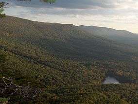 Lake at base of Cheaha Mountain | |
| Highest point | |
| Elevation | 2,413 ft (735 m) [1] |
| Prominence | 1,445 ft (440 m) [2] |
| Listing | U.S. state high point 35th |
| Coordinates | 33°29′08″N 85°48′31″W / 33.485511278°N 85.80866305°WCoordinates: 33°29′08″N 85°48′31″W / 33.485511278°N 85.80866305°W |
| Geography | |
 Cheaha Mountain | |
| Parent range | Talladega Mountains |
| Topo map | USGS Cheaha Mountain |
| Geology | |
| Age of rock | Devonian |
| Mountain type | quartzite rock |
| Climbing | |
| Easiest route | Road |
Cheaha Mountain /ˈtʃiːhɔː/, often called Mount Cheaha, is the highest natural point in the U.S. state of Alabama. It is located a few miles northwest of the town of Delta in Cheaha State Park, which offers a lodge, a restaurant, and other amenities.
Description
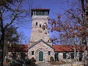
The highest point is marked with a USGS benchmark in front of Bunker Tower, a stone Civilian Conservation Corps building with an observation deck on top. The CCC also constructed a road to Cheaha, but the road has been closed for years. The old road is known as CC Road and contains interesting ruins. Near the peak is Bald Rock, which was recently improved with a wheelchair-accessible wooden walkway that provides an impressive overlook of the surrounding region. The entire area gives an impression of being at a much higher elevation than it actually is, in part because of the relatively low elevation of the adjacent area to the west.
Cheaha Mountain is part of the Talladega Mountains, a final southern segment of the Blue Ridge Mountains, unlike other elevations of the Appalachians in north Alabama, which are part of the Cumberland Plateau. The mountain is the highest point in the eastern portion of the Sun Belt (east of the Mississippi River, south of Interstate 20, and north of the Gulf of Mexico). Geologically it is composed of weakly metamorphosed sandstones and conglomerates of the Cheaha quartzite, of Silurian / Devonian age,[3] and stands high topographically due to the erosional resistance of these rocks.
The mountain was opened to the public as part of Cheaha State Park on June 7, 1939.[4]
The mountain is a host to several commercial and public service transmitters. These radio antennas, along with sundry structures dating back to commercial schemes by the state of Alabama in the 1970s, stand in stark contrast to the surrounding natural environment. The Calhoun County Amateur Radio Association has a repeater near the peak, and Alabama Public Television has its transmitter for WCIQ TV 7 on a tower 176 metres (577 ft) tall,[5] rebuilt after the January 1982 ice storm brought the previous one crashing to the ground.[6]
See also


- List of U.S. states by elevation
References
- ↑ "Cheehahaw". NGS data sheet. U.S. National Geodetic Survey. Retrieved 2008-10-12.
- ↑ "Cheaha Mountain, Alabama". Peakbagger.com. Retrieved 2012-11-07.
- ↑ "Mineral Resources Online Spatial Data: Geologic maps". mrdata.usgs.gov.
- ↑ "Local Legacies - Cheaha Mountain State Park". The Library of Congress; The American Folklife Center. Retrieved January 16, 2007.
- ↑ "Advanced Television Systems and Their Impact upon the Existing Television Broadcast Service". Federal Communications Commission. 14 August 1996. Retrieved January 16, 2007.
- ↑ "Wciq tower fall".
External links
| Wikimedia Commons has media related to: |