Johnson County, Wyoming
| Johnson County, Wyoming | |
|---|---|
 | |
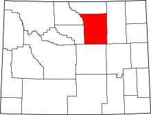 Location in the U.S. state of Wyoming | |
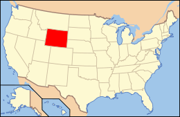 Wyoming's location in the U.S. | |
| Founded | 1881 |
| Seat | Buffalo |
| Largest city | Buffalo |
| Area | |
| • Total | 4,175 sq mi (10,813 km2) |
| • Land | 4,154 sq mi (10,759 km2) |
| • Water | 20 sq mi (52 km2), 0.5% |
| Population (est.) | |
| • (2016) | 8,486 |
| • Density | 2.1/sq mi (0.8/km2) |
| Congressional district | At-large |
| Time zone | Mountain: UTC−7/−6 |
| Website |
www |
Johnson County is a county in the north central part of the U.S. state of Wyoming. As of the 2010 census, the population was 8,569.[1] The county seat is Buffalo.[2] Kaycee is the only other incorporated town in the county.
Johnson County lies to the southeast of the Big Horn Mountains along Interstate 25 and Interstate 90. The Powder River flows northward through eastern Johnson County.
History
Johnson County was created on December 8, 1875 as Pease County from parts of Albany, Carbon, and Sweetwater Counties. It was organized in 1881.[3] The county was named for Dr. E. L. Pease of Uinta County. In 1879, the county was renamed Johnson, for E. P. Johnson, a Cheyenne attorney.[4][5]
In 1888, Sheridan County was created from a portion of Johnson County. In 1890, Big Horn County was created from Johnson County along with land from Fremont County and Sheridan County. In 1911, the boundaries of Johnson County and adjacent Crook, Natrona and Weston Counties were adjusted to run along federal land survey lines.
In April 1892, Johnson County was the scene of the Johnson County War, a range war between large cattle outfits and small stockgrowers.
Geography
According to the U.S. Census Bureau, the county has an area of 4,175 square miles (10,810 km2), of which 4,154 square miles (10,760 km2) is land and 20 square miles (52 km2) (0.5%) is water.[6]
Adjacent counties
- Sheridan County (north)
- Campbell County (east)
- Converse County (southeast)
- Natrona County (south)
- Washakie County (west)
- Big Horn County (northwest)
Major highways
National protected area
- Bighorn National Forest (part)
Demographics
| Historical population | |||
|---|---|---|---|
| Census | Pop. | %± | |
| 1880 | 637 | — | |
| 1890 | 2,357 | 270.0% | |
| 1900 | 2,361 | 0.2% | |
| 1910 | 3,453 | 46.3% | |
| 1920 | 4,617 | 33.7% | |
| 1930 | 4,816 | 4.3% | |
| 1940 | 4,980 | 3.4% | |
| 1950 | 4,707 | −5.5% | |
| 1960 | 5,475 | 16.3% | |
| 1970 | 5,587 | 2.0% | |
| 1980 | 6,700 | 19.9% | |
| 1990 | 6,145 | −8.3% | |
| 2000 | 7,075 | 15.1% | |
| 2010 | 8,569 | 21.1% | |
| Est. 2016 | 8,486 | [7] | −1.0% |
| U.S. Decennial Census[8] 1870–2000[9] 2010–2016[1] | |||
2000 census
As of the census[10] of 2000, there were 7,075 people, 2,959 households, and 2,006 families residing in the county. The population density was 2 people per square mile (1/km²). There were 3,503 housing units at an average density of 1 per square mile (0/km²). The racial makeup of the county was 97.03% White, 0.08% Black or African American, 0.64% Native American, 0.11% Asian, 0.55% from other races, and 1.58% from two or more races. 2.09% of the population were Hispanic or Latino of any race. 27.0% were of German, 15.2% English, 10.8% Irish and 7.9% American ancestry.
There were 2,959 households out of which 28.70% had children under the age of 18 living with them, 57.00% were married couples living together, 7.10% had a female householder with no husband present, and 32.20% were non-families. 28.50% of all households were made up of individuals and 12.00% had someone living alone who was 65 years of age or older. The average household size was 2.36 and the average family size was 2.89.
In the county, the population was spread out with 24.20% under the age of 18, 5.60% from 18 to 24, 23.50% from 25 to 44, 28.70% from 45 to 64, and 18.00% who were 65 years of age or older. The median age was 43 years. For every 100 females there were 96.60 males. For every 100 females age 18 and over, there were 94.30 males.
The median income for a household in the county was $34,012, and the median income for a family was $42,299. Males had a median income of $29,271 versus $20,469 for females. The per capita income for the county was $19,030. About 7.20% of families and 10.10% of the population were below the poverty line, including 9.10% of those under age 18 and 10.60% of those age 65 or over.
2010 census
As of the 2010 United States Census, there were 8,569 people, 3,782 households, and 2,410 families residing in the county.[11] The population density was 2.1 inhabitants per square mile (0.81/km2). There were 4,553 housing units at an average density of 1.1 per square mile (0.42/km2).[12] The racial makeup of the county was 96.5% white, 1.1% American Indian, 0.4% Asian, 0.2% black or African American, 0.7% from other races, and 1.1% from two or more races. Those of Hispanic or Latino origin made up 3.2% of the population.[11] In terms of ancestry, 31.6% were German, 22.4% were Irish, 18.3% were English, and 6.1% were American.[13]
Of the 3,782 households, 26.1% had children under the age of 18 living with them, 53.5% were married couples living together, 6.7% had a female householder with no husband present, 36.3% were non-families, and 31.8% of all households were made up of individuals. The average household size was 2.25 and the average family size was 2.83. The median age was 44.8 years.[11]
The median income for a household in the county was $45,638 and the median income for a family was $58,983. Males had a median income of $40,572 versus $30,352 for females. The per capita income for the county was $26,753. About 5.9% of families and 8.2% of the population were below the poverty line, including 8.0% of those under age 18 and 7.3% of those age 65 or over.[14]
Communities
City
- Buffalo (county seat)
Town
Unincorporated communities
Government and infrastructure
Like most of Wyoming, Johnson County is overwhelmingly Republican. It has been won by a Democrat only three times since Wyoming statehood – by William Jennings Bryan in 1896, by Woodrow Wilson by two votes with a 37.5 percent plurality in 1912, and by Franklin D. Roosevelt by seventy votes in his 1932 landslide. In the following election Johnson was Alf Landon’s second-best county in the Western United States behind Rio Blanco County in Colorado, and in the 1964 Democratic landslide it was Barry Goldwater’s best county in Wyoming and second-best in the West behind Utah’s traditional banner Republican county of Kane.
| Year | Republican | Democratic | Third parties |
|---|---|---|---|
| 2016 | 78.7% 3,477 | 14.4% 638 | 6.8% 302 |
| 2012 | 79.0% 3,363 | 17.6% 749 | 3.5% 147 |
| 2008 | 76.6% 3,334 | 20.9% 908 | 2.6% 112 |
| 2004 | 81.0% 3,231 | 16.9% 676 | 2.1% 84 |
| 2000 | 81.3% 2,886 | 15.6% 555 | 3.1% 109 |
| 1996 | 62.6% 2,071 | 24.6% 815 | 12.8% 423 |
| 1992 | 51.3% 1,614 | 20.9% 656 | 27.9% 876 |
| 1988 | 72.8% 2,081 | 24.7% 707 | 2.5% 70 |
| 1984 | 81.3% 2,634 | 17.2% 558 | 1.5% 49 |
| 1980 | 72.8% 2,291 | 20.2% 635 | 7.1% 222 |
| 1976 | 71.3% 2,042 | 27.8% 797 | 0.9% 27 |
| 1972 | 83.1% 2,203 | 16.5% 436 | 0.4% 11 |
| 1968 | 73.9% 1,737 | 16.9% 398 | 9.2% 217 |
| 1964 | 65.8% 1,640 | 34.2% 852 | |
| 1960 | 69.4% 1,806 | 30.7% 798 | |
| 1956 | 76.1% 1,842 | 23.9% 578 | |
| 1952 | 78.5% 1,980 | 21.5% 543 | 0.0% 1 |
| 1948 | 66.1% 1,351 | 33.4% 682 | 0.6% 12 |
| 1944 | 64.7% 1,384 | 35.3% 756 | |
| 1940 | 65.0% 1,460 | 34.8% 781 | 0.3% 6 |
| 1936 | 54.3% 1,266 | 40.7% 949 | 5.1% 118 |
| 1932 | 47.1% 1,101 | 50.0% 1,171 | 2.9% 68 |
| 1928 | 69.3% 1,369 | 29.8% 590 | 0.9% 18 |
| 1924 | 58.0% 1,097 | 26.5% 501 | 15.5% 293 |
| 1920 | 69.4% 1,202 | 30.3% 525 | 0.4% 6 |
| 1916 | 49.2% 814 | 49.0% 812 | 1.8% 30 |
| 1912 | 37.4% 522 | 37.5% 524 | 25.1% 350 |
| 1908 | 55.4% 781 | 43.6% 614 | 1.1% 15 |
| 1904 | 60.8% 725 | 38.5% 459 | 0.7% 8 |
| 1900 | 51.4% 466 | 48.6% 440 | |
| 1896 | 37.7% 284 | 62.0% 467 | 0.3% 2 |
| 1892 | 34.3% 309 | 65.7% 592 |
The Wyoming Department of Health Veteran’s Home of Wyoming, an assisted living facility for veterans and their dependents, is in Buffalo.[16][17] The Wyoming Board of Charities and Reform operated the facility until the agency was dissolved as a result of a state constitutional amendment passed in November 1990.[18]
See also
References
- 1 2 "State & County QuickFacts". United States Census Bureau. Archived from the original on July 12, 2011. Retrieved January 25, 2014.
- ↑ "Find a County". National Association of Counties. Archived from the original on 2011-05-31. Retrieved 2011-06-07.
- ↑ Long, John H., ed. (2004). "Wyoming: Individual County Chronologies". Wyoming Atlas of Historical County Boundaries. The Newberry Library. Retrieved August 19, 2015.
- ↑ Urbanek, Mae (1988). Wyoming Place Names. Missoula, MT: Mountain Press Publishing Company. ISBN 0-87842-204-8.
- ↑ Gannett, Henry (1905). The Origin of Certain Place Names in the United States. Govt. Print. Off. p. 169.
- ↑ "2010 Census Gazetteer Files". United States Census Bureau. August 22, 2012. Retrieved August 18, 2015.
- ↑ "Population and Housing Unit Estimates". Retrieved June 9, 2017.
- ↑ "U.S. Decennial Census". United States Census Bureau. Archived from the original on May 12, 2015. Retrieved August 18, 2015.
- ↑ "Historical Decennial Census Population for Wyoming Counties, Cities, and Towns". Wyoming Department of Administration & Information, Division of Economic Analysis. Retrieved January 25, 2014.
- ↑ "American FactFinder". United States Census Bureau. Retrieved 2011-05-14.
- 1 2 3 "DP-1 Profile of General Population and Housing Characteristics: 2010 Demographic Profile Data". United States Census Bureau. Retrieved 2016-01-12.
- ↑ "Population, Housing Units, Area, and Density: 2010 - County". United States Census Bureau. Retrieved 2016-01-12.
- ↑ "DP02 SELECTED SOCIAL CHARACTERISTICS IN THE UNITED STATES – 2006-2010 American Community Survey 5-Year Estimates". United States Census Bureau. Retrieved 2016-01-12.
- ↑ "DP03 SELECTED ECONOMIC CHARACTERISTICS – 2006-2010 American Community Survey 5-Year Estimates". United States Census Bureau. Retrieved 2016-01-12.
- ↑ Leip, David. "Dave Leip's Atlas of U.S. Presidential Elections". uselectionatlas.org. Retrieved 2018-04-05.
- ↑ "Veterans' Home of Wyoming Archived 2009-05-13 at the Wayback Machine.." Wyoming Department of Health. Retrieved on December 12, 2010. "Veterans’ Home of Wyoming 700 Veterans’ Lane Buffalo, WY 82834-9402."
- ↑ "Buffalo city, Wyoming." U.S. Census Bureau. Retrieved on December 12, 2010.
- ↑ "About the Department of Corrections." Wyoming Department of Corrections. Retrieved on August 22, 2010.
External links

- Buffalo, Wyoming Chamber of Commerce Website
Places adjacent to Johnson County, Wyoming | ||||||||||
|---|---|---|---|---|---|---|---|---|---|---|
| ||||||||||
Municipalities and communities of Johnson County, Wyoming, United States | ||
|---|---|---|
| City | | |
| Town | ||
| Unincorporated communities | ||