Mount Iliamna
| Mount Iliamna | |
|---|---|
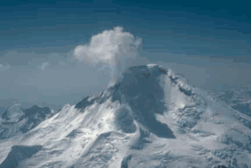 View of the glaciated north flank of Iliamna Volcano. A plume of steam and gas typically rises several hundred meters above the fumarole field. | |
| Highest point | |
| Elevation | 10,016 ft (3,053 m) |
| Prominence | 7,866 ft (2,398 m) |
| Listing | |
| Coordinates | 60°02′N 153°04′W / 60.033°N 153.067°WCoordinates: 60°02′N 153°04′W / 60.033°N 153.067°W |
| Geography | |
 Mount Iliamna Alaska | |
| Location | Lake Clark National Park and Preserve, Kenai Peninsula Borough, Alaska, US |
| Parent range | Chigmit Mountains, Aleutian Range |
| Topo map | USGS Lake Clark A-1 |
| Geology | |
| Mountain type | Stratovolcano |
| Volcanic arc/belt | Aleutian Arc |
| Last eruption | 1876 |
| Designated | 1976 |
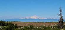
Mount Iliamna is a glacier-covered stratovolcano in the largely volcanic Aleutian Range in southwest Alaska. Located in the Chigmit Mountain subrange in Lake Clark National Park and Preserve, the volcano lies approximately 134 miles (215 km) southwest of Anchorage on the west side of lower Cook Inlet. Holocene eruptive activity from Iliamna is little known, but radiocarbon dating seems to indicate at least a few eruptions, all before the European settlement of Alaska. However, fumaroles located at about 8,990 feet (2,740 m) elevation on the eastern flank produce nearly constant plumes of steam and minor amounts of sulfurous gases. These plumes are quite vigorous and have resulted in numerous pilot reports and early historical accounts of "eruptions" at Iliamna Volcano.
See also
References
Sources
- "Iliamna". Global Volcanism Program. Smithsonian Institution.
- U.S. Geological Survey Open-File Report 95-271
- Alaska Volcano Observatory
Juneau (capital) | ||
| Topics |  | |
| Society | ||
| Regions | ||
| Largest cities pop. over 25,000 | ||
| Smaller cities pop. over 2,000 | ||
| Boroughs | ||
| Census Areas | ||