Raid Peak
| Raid Peak | |
|---|---|
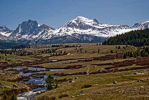 Viewed from Bonneville Basin, Raid Peak is at center and jagged Mount Bonneville is at left. | |
| Highest point | |
| Elevation | 12,537 ft (3,821 m) [1] |
| Prominence | 852 ft (260 m) [1] |
| Coordinates | 42°51′37″N 109°20′34″W / 42.86028°N 109.34278°WCoordinates: 42°51′37″N 109°20′34″W / 42.86028°N 109.34278°W [2] |
| Geography | |
 Raid Peak Sublette County, Wyoming, U.S. | |
| Parent range | Wind River Range |
| Topo map | USGS Mount Bonneville |
| Climbing | |
| Easiest route | Scramble, but east face class 5.8 |
Raid Peak (12,537 feet (3,821 m)) is located in the Wind River Range in the U.S. state of Wyoming.[3] The mountain is in the Bridger Wilderness of Bridger-Teton National Forest, 1.25 mi (2.01 km) west of the Continental Divide and .85 mi (1.37 km) south of Mount Bonneville. The east face of Raid Peak has one of the most spectacular cliff faces in the Wind River Range, rising almost 2,000 ft (610 m) above an unnamed lake with 1,700 ft (520 m) of that being a nearly sheer wall which is rated at class 5.8 and Grade IV-V. Most ascents up this face take at least a day if not two days.[4]
References
- 1 2 "Raid Peak, Wyoming". Peakbagger.com. Retrieved March 16, 2014.
- ↑ "Raid Peak". Geographic Names Information System. United States Geological Survey. Retrieved March 16, 2014.
- ↑ Mount Bonneville, WY (Map). TopoQwest (United States Geological Survey Maps). Retrieved March 16, 2014.
- ↑ Kelsey, Joe (January 1, 1994). Climbing and Hiking in the Wind River Mountains. Falcon Guides. p. 238. ISBN 978-0934641708.
This article is issued from
Wikipedia.
The text is licensed under Creative Commons - Attribution - Sharealike.
Additional terms may apply for the media files.