Goshen County, Wyoming
| Goshen County, Wyoming | ||
|---|---|---|
 | ||
| ||
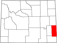 Location in the U.S. state of Wyoming | ||
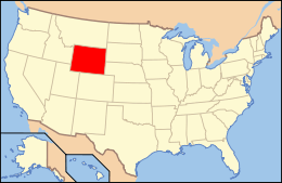 Wyoming's location in the U.S. | ||
| Founded | 1913 | |
| Seat | Torrington | |
| Largest city | Torrington | |
| Area | ||
| • Total | 2,232 sq mi (5,781 km2) | |
| • Land | 2,225 sq mi (5,763 km2) | |
| • Water | 6.8 sq mi (18 km2), 0.3% | |
| Population (est.) | ||
| • (2016) | 13,390 | |
| • Density | 6.0/sq mi (2.3/km2) | |
| Congressional district | At-large | |
| Time zone | Mountain: UTC−7/−6 | |

Goshen County is a county located in the U.S. state of Wyoming. As of the 2010 census, the population was 13,249.[1] Its county seat is Torrington.[2] The eastern boundary of the County borders the Nebraska state line.
Goshen County produces more cattle annually than any other Wyoming county. In 1997, the County had 688 farms and ranches averaging 1,840 acres. By 2007, there were 665 farms and ranches in the county.[3]
History
Goshen County was created on February 21, 1911 with land given up by Laramie County. It was organized in 1913.[4] Long before it was settled, or became Goshen County, the area had been part of territories, at one time or another, claimed by: Spain, France, Great Britain, Mexico, and the Republic of Texas. The Louisiana Purchase in 1803 permanently established the claim of the United States to the area.[3]
By the 1820s, a route along the North Platte River had become a route for fur traders and trappers bound for the Rocky Mountains. And, in the 1840s and 1850s, the same route functioned as part of the route for early pioneers following the historic Oregon Trail or Mormon Trail westward to Oregon, California or Utah. By the late 1850s, it was the route for regularly scheduled east-west stagecoaches carrying passengers and the U.S. mail, and for the short-lived Pony Express carrying mail from Missouri to California from April 1860 to November 1861. By October 1861, transcontinental telegraph lines had been completed along the route. From September 1876 to February 1887, a north-south, Cheyenne-Deadwood stage coach line ran through the County from Cheyenne to the gold fields of the Dakota Territory.[3]
The county was apparently named for Goshen Hole, a valley in the southwest part of the county. John C. Frémont camped in that area on July 14, 1843, and recorded that name in his journal, during his exploring expedition on the Oregon Trail.[5] At least four conflicting stories are available for the origin of the name "Goshen Hole". The Land of Goshen in Egypt, mentioned in the 45th chapter of the Genesis in the Bible, has been suggested as the most likely. And, John Hunton, who was ranching in the area by the 1870s, was told by Seth Ward, the post sutler at Fort Laramie, that the area was named for the Biblical land. The name of Goshen Hole first appeared on a map years later, in 1888.[3]
Geography
According to the U.S. Census Bureau, the county has a total area of 2,232 square miles (5,780 km2), of which 2,225 square miles (5,760 km2) is land and 6.8 square miles (18 km2) (0.3%) is water.[6] The County is situated in the High Plains east of the Rocky Mountains.
Adjacent counties
- Niobrara County - north
- Platte County - west
- Laramie County - south
- Banner County, Nebraska - southeast
- Scotts Bluff County, Nebraska - east
- Sioux County, Nebraska - east
National protected area
Climate

Situated on the North Platte River, Goshen County has a semi-arid climate (Köppen climate classification BSk.)
| Climate data for Torrington, Wyoming | |||||||||||||
|---|---|---|---|---|---|---|---|---|---|---|---|---|---|
| Month | Jan | Feb | Mar | Apr | May | Jun | Jul | Aug | Sep | Oct | Nov | Dec | Year |
| Record high °F (°C) | 70 (21) |
75 (24) |
85 (29) |
91 (33) |
100 (38) |
105 (41) |
111 (44) |
105 (41) |
101 (38) |
92 (33) |
83 (28) |
77 (25) |
111 (44) |
| Average high °F (°C) | 39.5 (4.2) |
45.0 (7.2) |
52.0 (11.1) |
61.2 (16.2) |
71.0 (21.7) |
82.4 (28) |
89.1 (31.7) |
87.3 (30.7) |
77.7 (25.4) |
65.4 (18.6) |
49.2 (9.6) |
41.0 (5) |
63.4 (17.5) |
| Daily mean °F (°C) | 24.9 (−3.9) |
30.0 (−1.1) |
37.5 (3.1) |
46.0 (7.8) |
56.2 (13.4) |
66.3 (19.1) |
72.3 (22.4) |
70.2 (21.2) |
59.8 (15.4) |
47.6 (8.7) |
34.0 (1.1) |
26.2 (−3.2) |
47.6 (8.7) |
| Average low °F (°C) | 10.3 (−12.1) |
14.9 (−9.5) |
23.0 (−5) |
30.7 (−0.7) |
41.3 (5.2) |
50.2 (10.1) |
55.5 (13.1) |
53.1 (11.7) |
41.9 (5.5) |
29.7 (−1.3) |
18.8 (−7.3) |
11.3 (−11.5) |
31.7 (−0.2) |
| Record low °F (°C) | −39 (−39) |
−33 (−36) |
−26 (−32) |
−17 (−27) |
11 (−12) |
29 (−2) |
39 (4) |
32 (0) |
14 (−10) |
−9 (−23) |
−23 (−31) |
−43 (−42) |
−43 (−42) |
| Average precipitation inches (mm) | 0.31 (7.9) |
0.40 (10.2) |
0.70 (17.8) |
1.68 (42.7) |
2.54 (64.5) |
2.09 (53.1) |
1.78 (45.2) |
1.19 (30.2) |
1.27 (32.3) |
0.95 (24.1) |
0.57 (14.5) |
0.36 (9.1) |
13.84 (351.6) |
| Average snowfall inches (cm) | 4.8 (12.2) |
4.9 (12.4) |
4.9 (12.4) |
3.2 (8.1) |
0.1 (0.3) |
0.0 (0) |
0.0 (0) |
0.0 (0) |
0.4 (1) |
2.1 (5.3) |
4.8 (12.2) |
6.8 (17.3) |
32 (81.2) |
| Average precipitation days (≥ 0.01 inch) | 4.3 | 3.5 | 5.3 | 7.5 | 9.8 | 8.7 | 7.6 | 6.3 | 5.9 | 4.7 | 4.0 | 3.9 | 71.5 |
| Average snowy days (≥ 0.1 inch) | 3.8 | 2.8 | 2.5 | 1.3 | 0.2 | 0.0 | 0.0 | 0.0 | 0.2 | 0.8 | 2.4 | 3.6 | 17.6 |
| Source #1: NOAA (normals, 1971–2000) [7] | |||||||||||||
| Source #2: The Weather Channel (Records) [8] NOAA NNDC Climate Data [9] | |||||||||||||
In the late spring of 2009, a weather research team known as VORTEX2 observed the full life cycle of a tornado near the border with Nebraska in eastern Goshen County.
Demographics
| Historical population | |||
|---|---|---|---|
| Census | Pop. | %± | |
| 1920 | 8,064 | — | |
| 1930 | 11,754 | 45.8% | |
| 1940 | 12,207 | 3.9% | |
| 1950 | 12,634 | 3.5% | |
| 1960 | 11,941 | −5.5% | |
| 1970 | 10,885 | −8.8% | |
| 1980 | 12,040 | 10.6% | |
| 1990 | 12,373 | 2.8% | |
| 2000 | 12,538 | 1.3% | |
| 2010 | 13,249 | 5.7% | |
| Est. 2016 | 13,390 | [10] | 1.1% |
| U.S. Decennial Census[11] 1870–2000[12] 2010–2016[1] | |||
2000 census
As of the census[13] of 2000, there were 12,538 people, 5,061 households, and 3,426 families residing in the county. The population density was 6 people per square mile (2/km²). There were 5,881 housing units at an average density of 3 per square mile (1/km²). The racial makeup of the county was 93.83% White, 0.20% Black or African American, 0.86% Native American, 0.20% Asian, 0.12% Pacific Islander, 3.65% from other races, and 1.14% from two or more races. 8.83% of the population were Hispanic or Latino of any race. 38.2% were of German, 10.4% English, 8.0% American and 8.0% Irish ancestry.
There were 5,061 households out of which 28.60% had children under the age of 18 living with them, 56.70% were married couples living together, 7.70% had a female householder with no husband present, and 32.30% were non-families. 27.60% of all households were made up of individuals and 13.10% had someone living alone who was 65 years of age or older. The average household size was 2.38 and the average family size was 2.90.
In the county, the population was spread out with 24.20% under the age of 18, 9.40% from 18 to 24, 24.30% from 25 to 44, 24.80% from 45 to 64, and 17.30% who were 65 years of age or older. The median age was 40 years. For every 100 females there were 98.90 males. For every 100 females age 18 and over, there were 95.00 males.
The median income for a household in the county was $32,228, and the median income for a family was $40,297. Males had a median income of $27,713 versus $17,584 for females. The per capita income for the county was $15,965. About 9.70% of families and 13.90% of the population were below the poverty line, including 16.30% of those under age 18 and 12.50% of those age 65 or over.
2010 census
As of the 2010 United States Census, there were 13,249 people, 5,311 households, and 3,466 families residing in the county.[14] The population density was 6.0 inhabitants per square mile (2.3/km2). There were 5,972 housing units at an average density of 2.7 per square mile (1.0/km2).[15] The racial makeup of the county was 94.5% white, 0.8% American Indian, 0.6% black or African American, 0.3% Asian, 0.1% Pacific islander, 2.4% from other races, and 1.2% from two or more races. Those of Hispanic or Latino origin made up 9.7% of the population.[14] In terms of ancestry, 38.3% were German, 15.5% were Irish, 15.3% were English, and 5.1% were American.[16]
Of the 5,311 households, 26.4% had children under the age of 18 living with them, 53.1% were married couples living together, 7.9% had a female householder with no husband present, 34.7% were non-families, and 30.0% of all households were made up of individuals. The average household size was 2.29 and the average family size was 2.82. The median age was 43.6 years.[14]
The median income for a household in the county was $42,590 and the median income for a family was $51,978. Males had a median income of $38,247 versus $25,277 for females. The per capita income for the county was $23,753. About 7.2% of families and 13.1% of the population were below the poverty line, including 21.3% of those under age 18 and 5.9% of those age 65 or over.[17]
Communities
City
- Torrington (county seat)
Towns
Census-designated places
Unincorporated communities
Government and infrastructure
The Goshen County Fairgrounds are just west of Torrington on U.S. Hwy 26/85. The fairground facilities host many events throughout the year, including an annual Goshen County Fair and numerous rodeo events.[18]
The Wyoming Department of Corrections Wyoming Medium Correctional Institution (WMCI) is located just east of Torrington on County Road 72 (Sheep Creek Rd.)[19][20][21] The WMCI, a facility of the Wyoming Department of Corrections, serves as an intake center for men not serving death sentences. The grand opening occurred on January 6, 2010.[22]
| Year | Republican | Democratic | Third parties |
|---|---|---|---|
| 2016 | 76.2% 4,418 | 15.9% 924 | 7.8% 454 |
| 2012 | 72.0% 4,178 | 25.1% 1,458 | 2.9% 170 |
| 2008 | 66.7% 3,942 | 31.0% 1,832 | 2.3% 138 |
| 2004 | 71.2% 4,114 | 27.1% 1,566 | 1.7% 99 |
| 2000 | 71.1% 3,922 | 26.1% 1,439 | 2.9% 159 |
| 1996 | 54.2% 2,989 | 34.9% 1,923 | 10.9% 601 |
| 1992 | 45.0% 2,395 | 33.0% 1,754 | 22.0% 1,169 |
| 1988 | 61.4% 3,075 | 37.5% 1,875 | 1.1% 55 |
| 1984 | 72.8% 3,776 | 26.3% 1,364 | 0.9% 44 |
| 1980 | 67.2% 3,572 | 25.8% 1,373 | 7.0% 370 |
| 1976 | 54.9% 2,764 | 44.9% 2,262 | 0.2% 12 |
| 1972 | 70.3% 3,629 | 29.3% 1,515 | 0.4% 20 |
| 1968 | 57.7% 2,719 | 32.4% 1,529 | 9.9% 468 |
| 1964 | 48.7% 2,604 | 51.4% 2,749 | |
| 1960 | 56.8% 3,178 | 43.2% 2,414 | |
| 1956 | 57.0% 2,825 | 43.0% 2,130 | |
| 1952 | 67.1% 3,396 | 32.6% 1,648 | 0.3% 14 |
| 1948 | 51.9% 2,029 | 47.2% 1,843 | 1.0% 37 |
| 1944 | 63.9% 2,674 | 36.2% 1,514 | |
| 1940 | 58.9% 2,861 | 40.8% 1,982 | 0.3% 15 |
| 1936 | 43.1% 2,047 | 55.6% 2,639 | 1.4% 65 |
| 1932 | 42.6% 1,954 | 55.5% 2,545 | 2.0% 91 |
| 1928 | 75.3% 2,483 | 23.6% 777 | 1.2% 38 |
| 1924 | 56.2% 1,603 | 16.3% 464 | 27.6% 788 |
| 1920 | 72.7% 1,496 | 26.8% 552 | 0.4% 9 |
| 1916 | 39.8% 770 | 56.6% 1,096 | 3.6% 70 |
| 1912 | 32.5% 292 | 35.4% 318 | 32.1% 288 |
Transportation
Highways
U.S. Highways
State Routes
Airport
See also
External links
References
- 1 2 "State & County QuickFacts". United States Census Bureau. Archived from the original on July 10, 2011. Retrieved January 25, 2014.
- ↑ "Find a County". National Association of Counties. Archived from the original on 2011-05-31. Retrieved 2011-06-07.
- 1 2 3 4 Zimmer, Vickie. "Goshen County, Wyoming". The Online Encyclopedia of Wyoming History. WyoHistory.org. Wyoming State Historical Society. Archived from the original on 2013-03-26. Retrieved 2015-06-30.
- ↑ Long, John H., ed. (2004). "Wyoming: Individual County Chronologies". Wyoming Atlas of Historical County Boundaries. The Newberry Library. Retrieved August 19, 2015.
- ↑ Urbanek, Mae (1988). Wyoming Place Names. Missoula, MT: Mountain Press Publishing Company. ISBN 0-87842-204-8.
- ↑ "2010 Census Gazetteer Files". United States Census Bureau. August 22, 2012. Retrieved August 5, 2015.
- ↑ "Climatography of the United States NO.81" (PDF). National Oceanic and Atmospheric Administration. Archived from the original (PDF) on July 13, 2014. Retrieved January 13, 2011.
- ↑ "Monthly Averages for Torrington, WY". The Weather Channel. Archived from the original on 2012-10-24. Retrieved January 13, 2011.
- ↑ "Climate Data Online Extremes Products". National Oceanic and Atmospheric Administration. Archived from the original on December 12, 2012. Retrieved June 3, 2012.
- ↑ "Population and Housing Unit Estimates". Retrieved June 9, 2017.
- ↑ "U.S. Decennial Census". United States Census Bureau. Archived from the original on May 12, 2015. Retrieved August 5, 2015.
- ↑ "Historical Decennial Census Population for Wyoming Counties, Cities, and Towns". Wyoming Department of Administration & Information, Division of Economic Analysis. Retrieved January 25, 2014.
- ↑ "American FactFinder". United States Census Bureau. Archived from the original on 2013-09-11. Retrieved 2011-05-14.
- 1 2 3 "DP-1 Profile of General Population and Housing Characteristics: 2010 Demographic Profile Data". United States Census Bureau. Retrieved 2016-01-12.
- ↑ "Population, Housing Units, Area, and Density: 2010 - County". United States Census Bureau. Retrieved 2016-01-12.
- ↑ "DP02 SELECTED SOCIAL CHARACTERISTICS IN THE UNITED STATES – 2006-2010 American Community Survey 5-Year Estimates". United States Census Bureau. Retrieved 2016-01-12.
- ↑ "DP03 SELECTED ECONOMIC CHARACTERISTICS – 2006-2010 American Community Survey 5-Year Estimates". United States Census Bureau. Retrieved 2016-01-12.
- ↑ "Goshen County Fairgrounds — Event Venue". Archived from the original on 2015-05-11. Retrieved 2015-06-30.
- ↑ "Torrington city, Wyoming." U.S. Census Bureau. Retrieved on December 12, 2010.
- ↑ "Wyoming Medium Correctional Institution (WMCI)". Archived from the original on 2011-07-25. ." Goshen County GIS Department. 2009. Retrieved on December 12, 2010.
- ↑ "Contact Institutions". Wyoming Department of Corrections. Retrieved August 22, 2010.
7076 Road 55F Torrington, WY 82240
- ↑ "Wyoming Medium Correctional Institution". Wyoming Department of Corrections. Retrieved August 22, 2010.
- ↑ Leip, David. "Dave Leip's Atlas of U.S. Presidential Elections". uselectionatlas.org. Retrieved 2018-04-05.
- ↑ "Goshen County Public and Private Airports". www.tollfreeairline.com. Retrieved 2018-04-05.
| Wikimedia Commons has media related to Goshen County, Wyoming. |
Places adjacent to Goshen County, Wyoming | ||||||||||
|---|---|---|---|---|---|---|---|---|---|---|
| ||||||||||
Municipalities and communities of Goshen County, Wyoming, United States | ||
|---|---|---|
| City | | |
| Towns | ||
| CDPs | ||
| Unincorporated community | ||