Kings Peak (Utah)
| Kings Peak | |
|---|---|
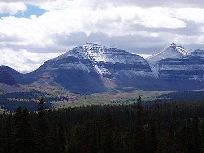 Close-up of Kings Peak as seen from the Henry's Fork Basin. Kings Peak is on the right, with Gunsight Pass on the left, August 2004. | |
| Highest point | |
| Elevation | 13,534 ft (4,125 m) NAVD 88[1] |
| Prominence | 6,348 ft (1,935 m) [1] |
| Listing |
|
| Coordinates | 40°46′35″N 110°22′22″W / 40.7763818°N 110.3728151°WCoordinates: 40°46′35″N 110°22′22″W / 40.7763818°N 110.3728151°W [3] |
| Geography | |
 Kings Peak Location within the State of Utah | |
| Location | Duchesne County, Utah, U.S. |
| Parent range | Uinta Mountains |
| Topo map | USGS King's Peak |
| Climbing | |
| Easiest route | Hike |
Kings Peak is the highest peak in the U.S. state of Utah,[4] with an elevation of 13,534 feet (4,125 m) NAVD 88[1] and an isolation of 166 mile.
Description

It lies just south of the spine of the central Uinta Mountains, in the Ashley National Forest in northeastern Utah, in north-central Duchesne County. It lies within the boundaries of the High Uintas Wilderness. The peak is approximately 79 miles (127 km) due east of central Salt Lake City, and 45 miles (72 km) due north of the town of Duchesne.
There are three popular routes to the summit; a scramble up the east slope, a hike up the northern ridge, and a long but relatively easy hike up the southern slope. The peak was named for Clarence King, a surveyor in the area and the first director of the United States Geological Survey.[5] Kings Peak is generally regarded as the hardest state highpoint which can be climbed without specialist rock climbing skills and/or guiding. The easiest route requires a 29 miles (47 km) round trip hike.
See also
References
- 1 2 3 "Kings Peak, Utah". Peakbagger.com. Retrieved 2009-12-27.
- ↑ "Utah County High Points". Peakbagger.com. Retrieved 2016-04-23.
- ↑ "Kings Peak". Geographic Names Information System. United States Geological Survey. Retrieved 2009-12-27.
- ↑ "Elevations and Distances in the United States". United States Geological Survey. 29 Apr 2005. Archived from the original on 2010-11-20. Retrieved 29 Mar 2009.
- ↑ Van Atta, Dale (Jan 22, 1977). "You name it - there's a town for it". The Deseret News. pp. W6. Retrieved 2015-10-18.
- Michael R. Kelsey, Utah Mountaineering Guide (Kelsey Publishing, 1983) pp. 94–95
External links

- "Kings Peak". SummitPost.org.
- Geology of Kings Peak