Mount Vsevidof
| Mount Vsevidof | |
|---|---|
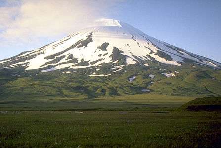 View, looking north, of Mount Vsevidof | |
| Highest point | |
| Elevation | 7,051 ft (2,149 m) |
| Prominence | 7,051 ft (2,149 m) |
| Listing | |
| Coordinates | 53°07′48″N 168°41′34.8″W / 53.13000°N 168.693000°WCoordinates: 53°07′48″N 168°41′34.8″W / 53.13000°N 168.693000°W |
| Geography | |
 Mount Vsevidof Alaska | |
| Location | Umnak Island, Alaska, U.S. |
| Parent range | Aleutian Range |
| Geology | |
| Mountain type | Stratovolcano |
| Volcanic arc/belt | Aleutian Arc |
| Last eruption | 1878 |
Mount Vsevidof (/ˌvɪzəˈviːdɒf/[1] or /vəˈʃeɪvɪdɒf/)[2] is a stratovolcano in the U.S. state of Alaska. Its summit is the highest point on Umnak Island, one of the eastern Aleutian Islands. Its symmetrical cone rises abruptly from its surroundings. Its most recent eruption was caused by an earthquake on March 9, 1957. The mountain erupted on March 11, 1957, and the eruption ended the next day.[3]
Its name comes from Russian and means "is seen from everywhere".
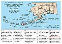
Map showing volcanoes of Alaska. The mark is set at the location of Mount Vsevidof.
See also
References
- ↑ Luke Smith, "The Lodge at the Edge of the World," Alaska magazine, February 2007.
- ↑ AllRefer.com Archived 2006-06-26 at the Wayback Machine.
- ↑ This is recorded as a "questionable eruption" by the Alaska Volcano Observatory (Vsevidof History Page). Other possible eruptions or other activity occurred in 1784, 1790, 1830, 1878, and 1880.
External links
- Volcanoes of the Alaska Peninsula and Aleutian Islands-Selected Photographs
- Mount Vsevidof on the Alaska Volcano Observatory Website
- "Vsevidof". Global Volcanism Program. Smithsonian Institution.
Juneau (capital) | ||
| Topics |  | |
| Society | ||
| Regions | ||
| Largest cities pop. over 25,000 | ||
| Smaller cities pop. over 2,000 | ||
| Boroughs | ||
| Census Areas | ||
This article is issued from
Wikipedia.
The text is licensed under Creative Commons - Attribution - Sharealike.
Additional terms may apply for the media files.