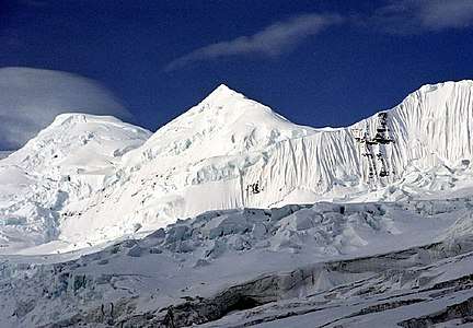
Mount Bona
| Mount Bona | |
|---|---|
 | |
| Highest point | |
| Elevation | 16,550 ft (5,040 m) [1] NAVD88 |
| Prominence | 6,900 ft (2,100 m) [1] |
| Isolation | 49.7 mi (80.0 km) [1] |
| Listing | |
| Coordinates | 61°23′08″N 141°44′55″W / 61.38556°N 141.74861°WCoordinates: 61°23′08″N 141°44′55″W / 61.38556°N 141.74861°W [2] |
| Geography | |
 Mount Bona Location in Alaska | |
| Location | Wrangell–St. Elias National Park and Preserve, Alaska, U.S. |
| Parent range | Saint Elias Mountains |
| Topo map | USGS McCarthy B-2 |
| Geology | |
| Mountain type | Stratovolcano |
| Last eruption | 847 AD |
| Climbing | |
| First ascent | July 2, 1930 by Allen Carpé, Terris Moore, Andrew Taylor |
| Easiest route | Glacier climb (Alaska Grade 2)[3] |
Mount Bona is one of the major mountains of the Saint Elias Mountains in eastern Alaska, and is the fifth-highest independent peak in the United States.[4] Mount Bona and its adjacent neighbor Mount Churchill are both large ice-covered stratovolcanoes. Bona has the distinction of being the highest volcano in the United States and the fourth-highest in North America, outranked only by the three highest Mexican volcanoes, Pico de Orizaba, Popocatépetl, and Iztaccíhuatl.
The mountain's massif is covered almost entirely by icefields and glaciers, and it is the principal source of ice for the Klutlan Glacier, which flows east for over 40 miles (64 km) into the Yukon Territory of Canada. The mountain also contributes a large volume of ice to the north-flowing Russell Glacier system.
Mount Bona was named by Prince Luigi Amedeo, Duke of the Abruzzi in 1897, who saw the peak while making the first ascent of Mount Saint Elias about 80 miles (130 km) to the southeast. He named it after the Bona, his racing yacht.[2] The mountain was first climbed in 1930 by Allen Carpé, Terris Moore, and Andrew Taylor, from the Russell Glacier on the west of the peak. The current standard route is the East Ridge; a climb of nearby Mount Churchill is a relatively easy addition via this route as well.[3]
See also
References and notes
- 1 2 3 "Mount Bona, Alaska". Peakbagger.com. Retrieved December 30, 2015.
- 1 2 "Mount Bona". Geographic Names Information System. United States Geological Survey. Retrieved 2007-03-10.
- 1 2 Wood, Michael; Coombs, Colby (2001). Alaska: A Climbing Guide. Mountaineers Books. pp. 161–162. ISBN 0-89886-724-X.
- ↑ This counts both the North and South Peaks of Mount McKinley (Denali), which is not a universally accepted practice; see the fourteener article. Bona's height is also often given as 16,500 feet (5,000 m) or as 16,552 feet (5,045 m).
- Richter, Donald H.; Rosenkrans, Danny S.; Steigerwald, Margaret J. (1995). Guide to the Volcanoes of the Western Wrangell Mountains, Alaska (PDF). USGS Bulletin 2072. Retrieved 2017-08-06.
- Richter, Donald H.; Preller, Cindi C.; Labay, Keith A.; Shew, Nora B. (2006). Geologic Map of the Wrangell-Saint Elias National Park and Preserve, Alaska. USGS Scientific Investigations Map 2877.
- Winkler, Gary R. (2000). A Geologic Guide to Wrangell—Saint Elias National Park and Preserve, Alaska: A Tectonic Collage of Northbound Terranes. USGS Professional Paper 1616. ISBN 0-607-92676-7.
- Wood, Charles A.; Kienle, Jürgen, eds. (1990). Volcanoes of North America. Cambridge University Press. ISBN 0-521-43811-X.
See also
External links
- "Mount Bona (Alaska)". Bivouac.com. Retrieved 2009-01-06.
- "Churchill". Global Volcanism Program. Smithsonian Institution. Retrieved 2009-01-06.
Juneau (capital) | ||
| Topics |  | |
| Society | ||
| Regions | ||
| Largest cities pop. over 25,000 | ||
| Smaller cities pop. over 2,000 | ||
| Boroughs | ||
| Census Areas | ||