Mount Saint Elias
| Mount Saint Elias | |
|---|---|
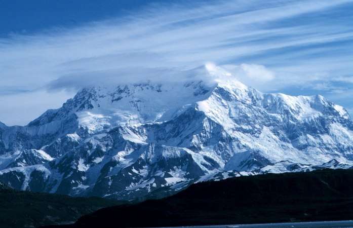 Mount St. Elias from Icy Bay, Alaska | |
| Highest point | |
| Elevation | 5489 m (18,008 ft) [1] NAVD88 |
| Prominence | 3429 m (11,250 ft) [1] |
| Isolation | 41.3 km (25.6 mi) [1] |
| Listing | |
| Coordinates | 60°17′36″N 140°55′46″W / 60.29333°N 140.92944°WCoordinates: 60°17′36″N 140°55′46″W / 60.29333°N 140.92944°W |
| Geography | |
 Mount Saint Elias Location on Alaska/Yukon border | |
| Location | Yakutat City and Borough, Alaska, U.S./Yukon, Canada |
| Parent range | Saint Elias Mountains |
| Topo map | USGS Mt. Saint Elias |
| Climbing | |
| First ascent | 1897 by Duke of the Abruzzi |
| Easiest route | glacier/snow/ice climb |
Mount Saint Elias may also refer to Mount Carmel

Mount Saint Elias, also designated Boundary Peak 186, is the second highest mountain in both Canada and the United States, being situated on the Yukon and Alaska border. It lies about 40 kilometres (25 mi) southwest of Mount Logan, the highest mountain in Canada. The Canadian side is part of Kluane National Park and Reserve, while the U.S. side of the mountain is located within Wrangell-St. Elias National Park and Preserve.
Its name in Tlingit is Yasʼéitʼaa Shaa, meaning "mountain behind Icy Bay", and is occasionally called Shaa Tlein "Big Mountain" by the Yakutat Tlingit. It is one of the most important crests of the Kwaashkʼiḵwáan clan since they used it as a guide during their journey down the Copper River.[2] Mount Fairweather at the apex of the British Columbia and Alaska borders at the head of the Alaska Panhandle is known as Tsalx̱aan, it is said this mountain and Yasʼéitʼaa Shaa (Mt. St. Elias) were originally next to each other but had an argument and separated. Their children, the mountains in between the two peaks, are called Tsalx̱aan Yátxʼi ("Children of Tsalxaan").
The mountain was first sighted by European explorers on July 16, 1741 by Vitus Bering of Russia. While some historians contend that the mountain was named by Bering, others believe that eighteenth century mapmakers named it after Cape Saint Elias, when it was left unnamed by Bering.[3]
Mount Saint Elias is notable for its immense vertical relief. Its summit rises 18,008 feet (5,489 m) vertically in just 10 miles (16 km) horizontal distance from the head of Taan Fjord, off of Icy Bay.
In 2007, an Austrian documentary, Mount. St. Elias, was made about a team of skier/mountaineers determined to make "the planet's longest skiing descent" – ascending the mountain and then skiing nearly all 18,000 feet down to the Gulf of Alaska; the movie finished editing and underwent limited release in 2009. The climbers ended up summiting on the second attempt and skiing down to 13,000 feet.[4]
Climbing history
Mt. St. Elias was first climbed on July 31, 1897 by an Italian expedition led by famed explorer Prince Luigi Amadeo di Savoia,[5][6] (who also reconnoitered the current standard route on K2 in 1909[7]) and including noted mountain photographer Vittorio Sella.
The second ascent was not until 1946, when a group from the Harvard Mountaineering Club including noted mountain historian Dee Molenaar climbed the Southwest Ridge route. The summit party comprised Molenaar, his brother Cornelius, Andrew and Betty Kauffman, Maynard Miller, William Latady, and Benjamin Ferris. (This expedition was somewhat unusual for the era in including a female member.) William Putnam was a member of the expedition but did not make the summit. They used eleven camps, eight of which were on the approach from Icy Bay, and three of which were on the mountain. They were supported by multiple air drops of food.[8]
The first winter ascent was made on February 13, 1996 by David Briggs, Gardner Heaton and Joe Reichert. After being flown in to 2,300 feet (700 m) on the Tyndal Glacier, they climbed the southwest ridge and followed the "Milk Bowl" variation in order to avoid 2,000 feet of loose rock on the normal route. The team had originally planned to begin their ascent from the ocean and cross the Tyndal Glacier but the terrain was in very poor condition.[9]
Mount Saint Elias is infrequently climbed today, despite its height, because it has no easy route to the summit and because of its prolonged periods of bad weather (mainly snow and low visibility).
Routes
- Abruzzi Ridge
- Livermore Ridge
See also
- List of mountain peaks of North America
- List of Boundary Peaks of the Alaska-British Columbia/Yukon border
Mount Saint Elias, project of songwriter Joey Coe.
References
- 1 2 3 "Mount Saint Elias, Alaska-Yukon". Peakbagger.com. Retrieved December 30, 2015.
- ↑ "Mount Saint Elias". Bivouac.com. Retrieved 2004-10-01.
- ↑ "Mount Saint Elias". Geographic Names Information System. United States Geological Survey. Retrieved 2007-10-31.
- ↑ Mount St. Elias – Official Movie Site. Retrieved March 11, 2010.
- ↑ "Naming Alaska's Mountains". Feature Article. American Alpine Journal. American Alpine Club. 1959. Retrieved 2016-12-09.
- ↑ "1897 Mount St. Elias". Virtual Museum Canada. Archived from the original on 2011-11-19.
- ↑ House, William P. (1939). "K2-1938". Feature Article. American Alpine Journal. American Alpine Club. Retrieved 2016-12-09.
- ↑ Miller, Maynard Malcolm (1947). "Yahtsétesha". Feature Article. American Alpine Journal. American Alpine Club: 257–268. Retrieved 2016-12-09.
- ↑ "Mount Saint Elias, First Winter Ascent". Climbs And Expeditions. American Alpine Journal. American Alpine Club. 1997. Retrieved 2016-12-09.
Works cited
- Wood, Michael; Cooms, Colby (2001). Alaska: a climbing guide. The Mountaineers.
External links

Juneau (capital) | ||
| Topics |  | |
| Society | ||
| Regions | ||
| Largest cities pop. over 25,000 | ||
| Smaller cities pop. over 2,000 | ||
| Boroughs | ||
| Census Areas | ||
| Regions | |
|---|---|
| Municipalities | |
| Communities | |
| Ghost towns | |
| Parks | |
| |