Douglas Knob
| Douglas Knob | |
|---|---|
 Douglas Knob Yellowstone National Park, Teton County, Wyoming | |
| Highest point | |
| Elevation | 8,507 ft (2,593 m) [1] |
| Coordinates | 44°18′48″N 110°50′51″W / 44.31333°N 110.84750°WCoordinates: 44°18′48″N 110°50′51″W / 44.31333°N 110.84750°W[1] |
| Geography | |
| Location | Yellowstone National Park, Teton County, Wyoming |
| Parent range | Madison Plateau |
| Topo map | Shoshone Geyser Basin |
Douglas Knob el. 8,507 feet (2,593 m) is an isolated mountain peak in the southwest section of Yellowstone National Park. Located just east of the Littler Fork of the Bechler River at the southern extent of the Madison Plateau, Douglas Knob is named for Joseph O. Douglas. In 1962, then Assistant Chief Ranger, William S. Chapman named the summit for Douglas who was an early Park Ranger. In 1921, Douglas was the Assistant Chief Ranger as well as the park's chief Buffalo Keeper.[2] The summit is less than .25 miles (0.40 km) east of the Bechler River trail.
See also
Notes
- 1 2 "Douglas Knob". Geographic Names Information System. United States Geological Survey.
- ↑ Whittlesey, Lee (1996). Yellowstone Place Names. Gardiner, MT: Wonderland Publishing Company. p. 90. ISBN 1-59971-716-6.
Yellowstone National Park - Cascade Corner | ||
|---|---|---|
Rivers, Waterfalls, Peaks and Lakes in the Cascade Corner (Southwest) section of the park | ||
| Rivers | 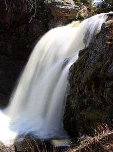 | |
| Waterfalls and Cascades | ||
| Lakes and Peaks | ||
| ||
This article is issued from
Wikipedia.
The text is licensed under Creative Commons - Attribution - Sharealike.
Additional terms may apply for the media files.