Breccia Peak (Wyoming)
| Breccia Peak | |
|---|---|
 | |
| Highest point | |
| Elevation | 11,007 ft (3,355 m) |
| Prominence | 200 ft (61 m) |
| Parent peak | Buffalo Fork Peak |
| Coordinates | 43°47′16″N 110°04′29″W / 43.78782°N 110.07484°WCoordinates: 43°47′16″N 110°04′29″W / 43.78782°N 110.07484°W |
| Geography | |
 Breccia Peak Wyoming | |
| Location | Teton County, Wyoming, United States |
| Parent range | Absaroka Range, Rocky Mountains |
| Climbing | |
| Easiest route | Hike (YDS Class 2) |
Breccia Peak (11,007 feet [3,355 m]) is a mountain in the southern Absaroka Range in the Rocky Mountains. It is located in Teton County in U.S. state of Wyoming near Togwotee Pass and close to the southwest border of the Teton Wilderness within the Bridger-Teton National Forest.
Geography
Breccia Peak is located about 2.5 miles (4.0 km) north of Togwotee Pass, which connects Jackson Hole, traversed by the Snake River, in the west from the Wind River valley in the east. The pass is part of the Great Continental Divide, and the mountain is located about 4.5 miles (7.2 km) west of it. The plateau-like summit shows very steep and rocky cliffs to the west and north, the Breccia Cliffs. To the east and southeast however, it shows a mainly grassy face. Between altitudes of 10,500 and 10,800 feet (3,200 and 3,300 m), there is a steep rock barrier, except for the section near the east and southeast ridge.[1]
In the west of the Breccia Peak there is no higher mountain for more than 30 miles (48 km), up to the Teton Range. Nevertheless, Breccia Peak is not particularly independent, because it has only 200 feet (61 m) of clean prominence from neighboring Buffalo Fork Peak in the north.[2]
About 1.25 miles (2.01 km) southwest of Breccia peak lies Lost Lake at an elevation of about 9,500 feet (2,900 m), a small but very scenic lake, where Breccia Cliffs can reflect off the water in the right setting.[3]
Geology
Breccia Peek is made of volcanic Absorka breccia, what explains its name.[2] The rocks in the section of the summit belong to the Wiggins Formation of the Thorofare Creek Group originated in the Upper Eocene. In the saddle between Breccia Peak and Angle Mountain lying northwest is an elongate irregular intrusive body of glassy flow-banded rhyodacite porphyry showing minor associated wall-rock alteration.[4]
Climbing
Breccia Peak is certainly one of the most rewarding summits in the Yellowstone Region reachable within two hours.[2] From the trailhead near U.S. Highway 26/U.S. Highway 287 approximately 0.6 miles (0.97 km) north of Togwotee Pass, visitors can get to the summit with a relatively easy hike (YDS Class 2, Swiss Alpine Club hiking grade T3). Starting at the pullout at the highway there is a well-established, but unofficial trail leading to the treeline. Early on there is a fork where climbers should bear left to get to Breccia Peak; the trail to the right leads to Sublette Peak (Brooks Mountain).
After some stream crossings the path reaches open timber. At an elevation of 10,000 feet (3,000 m), climbers get to a vast meadow southeast of Breccia Peak where they can see the southeast face of the mountain entirely. Here they have to leave the trail. The easiest route from there is to traverse the southeast face in northern direction to reach the east ridge, avoiding the steep rocky cliff in the middle. From there, climbers follow that ridge to the summit near the edge to the cliff on its right hand end mostly on grass. A somewhat shorter alternative involving a little more scrambling is to avoid the steep rocky cliff on its left hand, southwest end. To do so, climbers have to head west from the meadow to the south ridge of Breccia Peak and follow this ridge to the summit.[2]
The southeast face of the mountain above timber is particularly suitable for backcountry skiing. There are only short runs, but many variants are possible.[5]
The summit was in the zone of totality of the Solar eclipse of August 21, 2017. It was called a "quirky place to see the total solar eclipse" in the Wind River region in Wyoming.[6]
 Breccia Peak from the pullout 0.6 miles north of Togwotee Pass, in the front the start of the track.
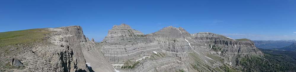
 Breccia Peak from southeast while ascending on normal route. The steep cliff in the middle can be passed on the left or on the right.
 Northern cliffs of Breccia Peak.
 First col between Breccia Peak (left) and Buffalo Fork Peak, Mount Moran in background.
 View from Breccia Peak to west, to Teton Range, Lost Lake in the foreground.
 Survey marker at the summit of Breccia Peak.
References
- ↑ "Breccia Peak". listsofjohn.com. Retrieved September 1, 2017.
- 1 2 3 4 "Breccia Peak". summitpost.org. Retrieved September 1, 2017.
- ↑ Hunger, Bill (2008). Hiking Wyoming: 110 Of The State's Best Hiking Adventures (2nd ed.). pp. 248–250. ISBN 978-1-4617-4576-1.
- ↑ Antweiler, J. C.; Love, J. D.; Prostka, Harold J.; Kulik, Dolores M.; Anderson, Lennart A.; Williams, Frank E.; Jinks, Jimmie E.; Light, Thomas D. (1989). "Mineral Resources of the Teton Wilderness and Adjacent Areas, Teton, Fremont, and Park Counties, Wyoming" (PDF). U.S. Geological Survey Bulletin 1781. United States Government Printing Office. Plate 1.
- ↑ "Breccia Peak Backcountry Skiing and Snowboarding". rootsrated.com. Retrieved September 1, 2017.
- ↑ "Quirky Places to See the Total Solar Eclipse". Wind River Visitors Council. Retrieved September 1, 2017.