Mount Bonneville
| Mount Bonneville | |
|---|---|
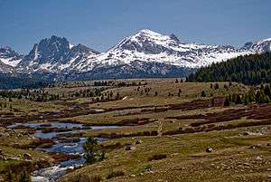 Mount Bonneville is the rugged mountain on the left in this view from Bonneville Basin. Raid Peak is at center. | |
| Highest point | |
| Elevation | 12,590 ft (3,840 m) [1] |
| Prominence | 785 ft (239 m) [1] |
| Coordinates | 42°52′19″N 109°20′22″W / 42.87194°N 109.33944°WCoordinates: 42°52′19″N 109°20′22″W / 42.87194°N 109.33944°W [2] |
| Geography | |
 Mount Bonneville Sublette County, Wyoming, U.S. | |
| Parent range | Wind River Range |
| Topo map | USGS Mount Bonneville |
| Climbing | |
| First ascent | 1946 (Weir Stewart and Harry Willits) |
Mount Bonneville (12,590 feet (3,840 m)) is located in the Wind River Range in the U.S. state of Wyoming.[3] The summit is located in the Bridger Wilderness of Bridger-Teton National Forest, immediately west of the Continental Divide. Mount Bonneville is a distinctively iconic peak of the Wind River Range, and was named after explorer Benjamin Bonneville.
References
- 1 2 "Mount Bonneville, Wyoming". Peakbagger.com. Retrieved March 16, 2014.
- ↑ "Mount Bonneville". Geographic Names Information System. United States Geological Survey. Retrieved March 16, 2014.
- ↑ Mount Bonneville, WY (Map). TopoQwest (United States Geological Survey Maps). Retrieved March 16, 2014.
This article is issued from
Wikipedia.
The text is licensed under Creative Commons - Attribution - Sharealike.
Additional terms may apply for the media files.