Mount Norris
| Mount Norris | |
|---|---|
 January 2010 | |
| Highest point | |
| Elevation | 9,842 ft (3,000 m) [1] |
| Coordinates | 44°52′28″N 110°05′41″W / 44.87444°N 110.09472°WCoordinates: 44°52′28″N 110°05′41″W / 44.87444°N 110.09472°W [1] |
| Geography | |
 Mount Norris Yellowstone National Park, Park County, Wyoming | |
| Topo map | Wahb Springs |
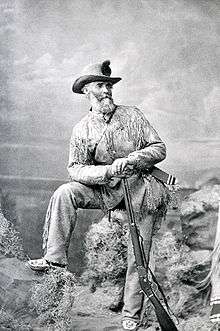
Mount Norris el. 9,842 feet (3,000 m) is a mountain peak in the northeast section of Yellowstone National Park in the Absaroka Range. In 1875, the peak was named for and named by Philetus Norris, the second park superintendent (1877–1882). Norris was on a visit to the park with several mountain guides, including Collins Jack Yellowstone Jack Baronette. They ascended the peak at the head of the Lamar Valley and presumed they were the first white men to do so, thus naming it Mount Norris.[2]

South Ridge
See also
Notes
- 1 2 "Mount Norris". Geographic Names Information System. United States Geological Survey.
- ↑ Whittlesey, Lee (1988). Yellowstone Place Names. Helena, MT: Montana Historical Society Press. p. 106. ISBN 0-917298-15-2.
Yellowstone National Park - Tower-Roosevelt and Lamar Valley | ||
|---|---|---|
Geography, historic structures and other attractions in the Tower Roosevelt and Lamar Valley areas | ||
| Structures and History |  | |
| Geography and Geology |
| |
| ||
This article is issued from
Wikipedia.
The text is licensed under Creative Commons - Attribution - Sharealike.
Additional terms may apply for the media files.