Absaroka Range
| Absaroka Range | |
|---|---|
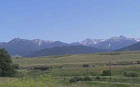 Absaroka range as seen from west of Livingston, Montana | |
| Highest point | |
| Peak | Francs Peak |
| Elevation | 13,153 ft (4,009 m) |
| Coordinates | 43°57′41″N 109°19′51″W / 43.96139°N 109.33083°WCoordinates: 43°57′41″N 109°19′51″W / 43.96139°N 109.33083°W |
| Dimensions | |
| Length | 150 mi (240 km) |
| Width | 75 mi (121 km) |
| Geography | |
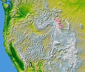 Absaroka Range is shown highlighted in pink on a map of the western United States
| |
| Country | United States |
| States | Montana and Wyoming |
| Parent range | Rocky Mountains |
| Borders on |
Beartooth Mountains Wind River Range |
The Absaroka Range (/əbˈsɔːrkə/ or locally /əbˈsɔːrki/) is a sub-range of the Rocky Mountains in the United States. The range stretches about 150 mi (240 km) across the Montana-Wyoming border, and 75 miles at its widest, forming the eastern boundary of Yellowstone National Park along Paradise Valley (Montana), and the western side of the Bighorn Basin. The range borders the Beartooth Mountains to the north and the Wind River Range to the south. The northern edge of the range rests along I-90 and Livingston, Montana. The highest peak in the range is Francs Peak, located in Wyoming at 13,153 ft (4,009 m). There are 46 other peaks over 12,000 ft (3,700 m).
Geography
The range is drained by the Yellowstone River and various tributaries, including the Bighorn River.
Most of the range lies within protected lands including Yellowstone Park, the Absaroka-Beartooth Wilderness, North Absaroka Wilderness, Teton Wilderness, and Washakie Wilderness, spanning the Bridger-Teton National Forest, Custer National Forest, Gallatin National Forest, and Shoshone National Forest.
U.S. Highway 212 from Billings, Montana to Yellowstone climbs over Beartooth Pass 10,947 ft (3,337 m) in the neighboring Beartooth Mountains before winding through the Absarokas to the northeast gate of Yellowstone National Park. It is only open during the summer. U.S Route 14/16/20 follows the Shoshone River from Cody through the range to the eastern gate of the park.
History
The range is named after the Absaroka Indians.[1] The name is derived from the Hidatsa name for the Crow people; it means "children of the large-beaked bird."[2] (In contrast, the Crow name, Awaxaawe Báaxxioo, means "Pointed Mountains [Like Sand Castles].")
John Colter, who may have been the first white person to visit the area, probably traveled along the foot of the Absarokas in 1807 during his reconnaissance of the Yellowstone region.[3] Early explorers also included Gustavus Cheyney Doane and Nathaniel P. Langford, who climbed the summit of Colter Peak in 1870.[4]
USS Absaroka was named after this mountain range.
Geology
Geologically, the section of the range in Wyoming consists of volcanic breccia, whereas there is a transition to granite and gneiss bedrock further north of the state line.[5]
Absaroka Volcanic Province
Igneous rocks of the Absaroka Volcanic Province cover an area of approximately 23,000 km2 (8,900 sq mi; 2,300,000 ha) in southwestern Montana and northwestern Wyoming, including roughly one third of Yellowstone National Park. These extrusive rocks were erupted during the Eocene Epoch of the Paleogene Period. Radiometric dating has shown that eruptive activity lasted from about 53 to 43.7 million years ago. The eroded remnants of many large stratovolcanoes are found in the area. The dissection of these long extinct volcanoes by erosion allows geologists to see volcanic structures that are impossible to see in active volcanoes. Many terms now widely used in volcanology originated in nineteenth century field studies of these ancient volcanoes.[6]
Gallery
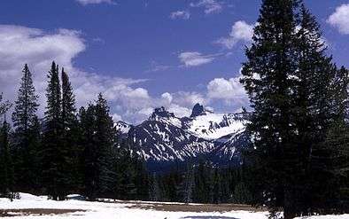 Pilot and Index peaks in the Absaroka Mountains
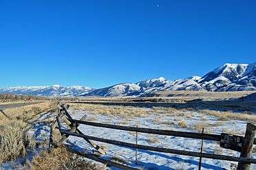 Western face of Absarokas from Paradise Valley (Montana)
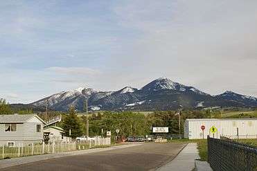 Northern Absaroka range as seen from Livingston, Montana
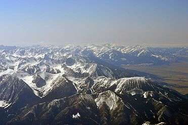 Northwest expanse of Absarokas as viewed from 15,000 feet (4,600 m) over Livingston, Montana
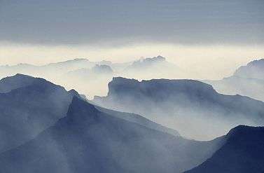 The mountains in August 19, 1988, smoky thanks to the Yellowstone fires of 1988.
See also
References
- ↑ Gannett, Henry (1905). The Origin of Certain Place Names in the United States. Washington, D.C.: United States Geological Survey. p. 16. Retrieved August 22, 2017.
- ↑ Montana Place Names: From Alzada To Zortman. Montana Historical Society Press. 2009. p. 2. ISBN 9780975919613.
- ↑ Mattes, Merrill J. (1962). "III. John Colter, The Phantom Explorer—1807-1808". Colter's Hell and Jackson's Hole. Yellowstone Library and Museum Association & Grand Teton Natural History Association.
- ↑ Langford, Nathaniel Pitt (1905). Diary of the Washburn expedition to the Yellowstone and Firehole rivers in the year 1870. Retrieved 28 July 2015.
- ↑ "Absaroka Range". summitpost.org. June 2, 2013. Retrieved July 27, 2015.
- ↑ Hiza, Margaret M. (Spring 1998). "The Geologic History of the Absaroka Volcanic Province" (PDF). Yellowstone Science. 6 (2): 2. Retrieved 28 July 2015.
| Wikimedia Commons has media related to Absaroka Range. |