Humpy Peak
| Humpy Peak | |
|---|---|
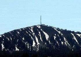 Humpy Peak in 2007. | |
| Highest point | |
| Elevation | 10,875 ft (3,315 m) NAVD 88[1] |
| Prominence | 9,800 feet (2,987 m) [2] |
| Coordinates | 40°52′12″N 111°00′01″W / 40.870054097°N 111.000366967°WCoordinates: 40°52′12″N 111°00′01″W / 40.870054097°N 111.000366967°W [1] |
| Geography | |
 Humpy Peak Location in Utah | |
| Location | Summit County, Utah, U.S. |
| Parent range | Uinta Mountains |
| Climbing | |
| Easiest route | Hike or private road. |
Humpy Peak is a peak located in the Uinta Mountain Range in northern Utah. It is approximately 27.56 miles (44 km) south of Evanston, Wyoming and 21.29 miles (34 km) east of Coalville, Utah. The summit has an elevation of 10,875 feet (3,315 m).[2]
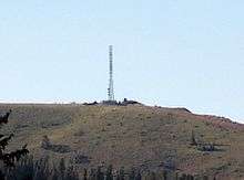
Telecommunications tower
Telecommunications and radio broadcasting occupy the mountains summit. It has a single tower near the summit that broadcasts a variety of signals to the surrounding area. The Utah Communications Agency Network (UCANN) operates a transmitter at the location.[3] The United States Forest Service also operates a transmitter on the mountain.[4]
Radio stations
The following FM radio stations broadcast their main signals from the tower located on Humpy Peak. Three new stations have construction permits to move to the mountain. Several other FM stations may also be pending moves to the peak.[5]
| Call sign | Frequency | Format |
|---|---|---|
| KUTC | 95.7 | Easy Listening |
| KZNS-FM | 97.5 | Regional Mexican |
| KADQ (CP) | 98.3 | Classic Rock |
| KYMV | 100.7 | Top 40 |
| KEGA | 101.5 | Country |
| KDUT | 102.3 | Regional Mexican |
| KSQN | 103.1 | 80's New Wave |
| KNYN | 103.9 | Country |
| KNIV | 104.7 | Regional Mexican |
| KDWY (CP) | 105.5 | Country |
| KBMG | 106.3 | Spanish Contemporary |
| KEGH | 107.1 | Regional Mexican |
| KUMT | 107.9 | Top 40 |
FM stations use Humpy Peak as a transmitter location primarily because of a terrain shadow of nearby Salt Lake City. This allows the stations to drop onto 2nd adjacent frequencies in Salt Lake City, without interfering with other stations in the main market area. All of the stations listed above use booster signals that are synchronized with the main station. These fill in the gaps that the main signal otherwise wouldn't cover well. For example, KSQN has 6 boosters to cover the Salt Lake metro area, which is behind the Wasatch Mountain Range from the main transmitter.[7] Stations like this are generally known as "rimshots."
Geology
Humpy Peak is located on the northwestern flank of the Uinta Mountain range in central Summit County. Geology of the peak is common with Uinta Mountain range as well. The peak is accessible via a road on private property, that begins at Utah State Route 150. The peak is 12.74 miles (21 km) from the Mirror Lake recreation site. Because of its height, and the terrain shadow the Wasatch Range provides, Humpy was likely chosen because signals from the peak cover a significant distance, well into Wyoming. This provides Evanston and surrounding communities in southwestern Wyoming with more radio stations. Stations on the peak often can be received as far northeast as Green River, Wyoming.[8]
References
- 1 2 "Windy". NGS data sheet. U.S. National Geodetic Survey. Retrieved 2016-04-19.
- 1 2 "Humpy Peak, Utah". Peakbagger.com. Retrieved 2016-04-19.
- ↑ Radio Reference - Scanner Frequency Database
- ↑ Summit County (UT) - RadioReference
- ↑ The Big Trip 2007, part IV: East to Park City and Wyoming - Fybush.com
- ↑ Radio stations in Coalville, Utah (Using this as a guide for the stations on Humpy)
- ↑ KSQN Radio Station Information
- ↑ Green River FM DX