Static Peak
| Static Peak | |
|---|---|
 Static Peak | |
| Highest point | |
| Elevation | 11,308 ft (3,447 m) [1] |
| Prominence | 343 ft (105 m) [1] |
| Coordinates | 43°40′58″N 110°48′58″W / 43.68278°N 110.81611°WCoordinates: 43°40′58″N 110°48′58″W / 43.68278°N 110.81611°W [2] |
| Geography | |
 Static Peak | |
| Parent range | Teton Range |
| Topo map | USGS Grand Teton |
| Climbing | |
| Easiest route | Scramble/Technical class 3 to 5.8 |
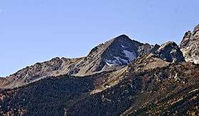
Static Peak (11,308 feet (3,447 m)) is located in the Teton Range, Grand Teton National Park, in the U.S. state of Wyoming.[3] Located .48 miles (0.77 km) southeast of Buck Mountain, the summit is also east of the Alaska Basin Trail, from a point known as Static Peak Divide, the summit can be climbed in a scramble. Below the summit on the north face, a small remnant glacier persists, sheltered from direct sunlight by steep cliffs.[4] Timberline Lake lies to the north of the peak.
References
- 1 2 "Static Peak, Wyoming". Peakbagger.com. Retrieved 2011-05-28.
- ↑ "Static Peak". Geographic Names Information System. United States Geological Survey. Retrieved 2011-05-28.
- ↑ Grand Teton, WY (Map). TopoQwest (United States Geological Survey Maps). Retrieved 2011-05-28.
- ↑ "Welcome to the Tetons". Summitpost. Retrieved 2011-05-28.
This article is issued from
Wikipedia.
The text is licensed under Creative Commons - Attribution - Sharealike.
Additional terms may apply for the media files.