Mount Chirripó
| Mount Chirripó | |
|---|---|
 | |
| Highest point | |
| Elevation | 3,820 m (12,530 ft) [1] |
| Prominence | 3,727 m (12,228 ft) [1] |
| Isolation | 878 kilometres (546 mi) |
| Listing | |
| Coordinates | 9°29′2.7″N 83°29′19.2″W / 9.484083°N 83.488667°WCoordinates: 9°29′2.7″N 83°29′19.2″W / 9.484083°N 83.488667°W |
| Geography | |
 Mount Chirripó Location in Costa Rica | |
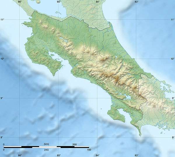
| Location | Chirripó National Park, Costa Rica |
| Parent range | Talamanca Range |
| Climbing | |
| First ascent |
1904 Agustin Blessing |
| Easiest route | Hiking |
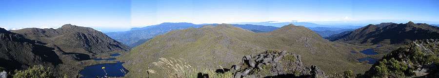
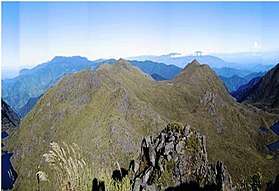
Mount Chirripó is the highest mountain in Costa Rica with an elevation of 3,820 meters (12,533 feet). It is located in Chirripó National Park and is noted for its ecological wealth. The mountain was named "Chirripo," meaning "land of eternal waters", by native Americans because there are many lakes and streams around the mountain.[2] The high peaks in Chirripó National Park and La Amistad International Park host important areas of Talamancan montane forest and Costa Rican Páramo with high endemism and an extremely high biodiversity. The peaks of these mountains constitute sky islands for many species of plants and animals. Snow has not fallen on the peak in the past 100 years or so, according to the University of Costa Rica, but hail is sometimes reported.
The great height of Mount Chirripó relative to its surroundings is also evidenced by its particularly high topographic prominence of 3,727 m (12,228 ft),[1] which makes it the 37th most prominent peak in the world. On clear days it is possible to see across the country from the Pacific Ocean to the Caribbean Sea.[3]
Climbing Chirripó is possible by obtaining a permit from the National Park office in San Gerardo de Rivas. From the trailhead, the summit can be reached via a 19.5-kilometer (12.1 mile) hike.[4]
Temperatures on the peak range from 4˚C–18˚C. Temperatures can drop to below freezing at night.
History
In 1904, Agustin Blessing Presinger made the first ascent to the peak. Since 1953, there have been five major fires in the area. The first official hiking trail was constructed in 1965; it led to a small sheet-metal hut five kilometers away from the peak. Today, the hut has been replaced by a concrete building visited by 7,000 people each year. In 1975, Chirripó National Park was founded, enclosing and protecting 500 square kilometers of rain forest and mountains around the peak.[5]
Forest fires occurred in 1976,[6] in the 1990s,[7] and in 2012.[8]
Route
The hike starts 1,500 meters above sea level in the village of San Gerardo on the Talamanca Range. From the valley, the path rises through fields and woodlands before ascending through lush rainforest. The forest gradually turns into scrubland. The trail continuously ascends and descends through ridges and valleys until it reaches the final visitors' refuge at 3,392 meters. From the refuge, there is a remaining two hour hike. Once the last ridge is crossed, there is a remaining 200 meters of steep path. The summit is a 6-meter wide platform of rocks[9].
See also
References
- 1 2 3 "Central America ultra-prominent peaks". PeakList.org. Retrieved 2007-04-07.
- ↑ http://www.hikingchirripo.com/all-about-chirripo
- ↑ "Chirripó National Park". costa-rica-guide.com. Retrieved 2010-02-10.
- ↑ "notes on climbing Chirripo". peakbagging.com. Retrieved 2011-04-09.
- ↑ Hepworth, Adrian (2008). Wild Costa Rica: the wildlife & landscapes of Costa Rica. Mit Press. ISBN 9780262083836.
- ↑ Harry Pariser. "First Fire". Explore Costa Rica. Retrieved 2010-02-10.
- ↑ "Second Fire (Weak)". blog on wordpress.com. Retrieved 2010-02-10.
- ↑ David Delgado. "Brigadistas combaten últimas llamas en el Chirripó". Diario La Nación. Archived from the original on 2012-03-10. Retrieved 2012-03-10.
- ↑ Hepworth, Adrian (2008). Wild Costa Rica: the wildlife & landscapes of Costa Rica. Mit Press. ISBN 9780262083836.
External links
| Wikimedia Commons has media related to Cerro Chirripó. |