Timms Hill
| Timms Hill | |
|---|---|
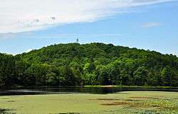 Timms Hill, Wisconsin, July 2014. | |
| Highest point | |
| Elevation | 1,951.5 ft (594.8 m) [1] |
| Prominence | 425 ft (130 m) [2] |
| Listing | U.S. state high point 39th |
| Coordinates | 45°27′03″N 90°11′43″W / 45.450884317°N 90.195397889°WCoordinates: 45°27′03″N 90°11′43″W / 45.450884317°N 90.195397889°W [1] |
| Geography | |
 Timms Hill Wisconsin | |
| Location | Price County, Wisconsin, US |
| Topo map | USGS Timms Hill |
| Climbing | |
| Easiest route | Hike |
Timms Hill is the highest natural point in the U.S. state of Wisconsin.[3] Located in north-central Wisconsin in Timms Hill County Park in the Town of Hill in Price County, Timms Hill has an elevation of 1,951.5 ft (595 m). It is less than 1 mile (1.6 km) south of Highway 86, about midway between Ogema and Spirit and about 23 miles (37 km) west of Tomahawk.[4]
A public lookout tower is atop the hill. Visible to the southeast is Rib Mountain (elev. 1,924 ft, 586 m), 44 miles away by line of sight.
The 10-mile (16 km) Timms Hill Trail connects to the Ice Age Trail,[5] a National Scenic Trail stretching 1,200 miles (1,900 km) across glacial terrain in Wisconsin.
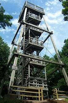
The tower at the top of Timms Hill.
See also
References
- 1 2 "Ogema". NGS data sheet. U.S. National Geodetic Survey. Retrieved 2010-01-26.
- ↑ "Timms Hill, Wisconsin". Peakbagger.com. Retrieved 2012-10-17.
- ↑ "Timms Hill (Wisconsin)". Geographic Names Information System. United States Geological Survey.
- ↑ Department of Transportation-Price County
- ↑ Timm's Hill Trail Web Site
External links
- "Timms Hill". Geographic Names Information System. United States Geological Survey. Retrieved 2008-12-18.
- "Timms Hill, WI". TopoQuest Topographic Map Viewer. Retrieved 2008-12-18.
- "Timms Hill". SummitPost.org. Retrieved 2008-12-18.
- "Timms Hill Trail, WI". website. Retrieved 2018-01-03.
This article is issued from
Wikipedia.
The text is licensed under Creative Commons - Attribution - Sharealike.
Additional terms may apply for the media files.