National Register of Historic Places listings in Comal County, Texas
This is a list of the National Register of Historic Places listings in Comal County, Texas.
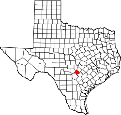
This is intended to be a complete list of properties and districts listed on the National Register of Historic Places in Comal County, Texas. There are three districts and 15 individual properties listed on the National Register in the county. One property is located within a National Natural Landmark. Ten individually listed properties comprise 11 Recorded Texas Historic Landmarks including one that is also designated a State Antiquities Landmark. Two districts contain several more Recorded Texas Historic Landmarks.
- This National Park Service list is complete through NPS recent listings posted October 11, 2018.[1]
Current listings
The publicly disclosed locations of National Register properties and districts may be seen in a mapping service provided.[2]
| [3] | Name on the Register[4] | Image | Date listed[5] | Location | City or town | Description |
|---|---|---|---|---|---|---|
| 1 | Anhalt Hall | 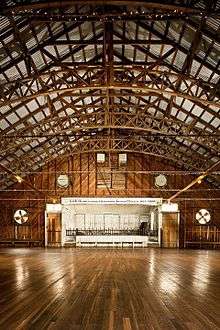 |
July 23, 2018 (#100002697) |
2390 Anhalt Rd. 29°48′50″N 98°28′44″W / 29.813897°N 98.478908°W |
Spring Branch | |
| 2 | Arnold-Rauch-Brandt Homestead | July 23, 2018 (#100002698) |
TX 46 W, Parcel 393224 29°43′43″N 98°12′51″W / 29.728545°N 98.214239°W |
New Braunfels | ||
| 3 | Brauntex Theater | .jpg) |
March 24, 2008 (#08000240) |
290 W. San Antonio 29°42′05″N 98°07′35″W / 29.701319°N 98.126458°W |
New Braunfels | |
| 4 | Andreas Breustedt House | 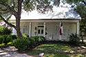 |
July 22, 1982 (#82004497) |
1370 Church Hill Dr. 29°42′33″N 98°05′47″W / 29.709164°N 98.096411°W |
New Braunfels | Recorded Texas Historic Landmark |
| 5 | Comal County Courthouse | 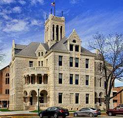 |
December 12, 1976 (#76002017) |
N. Sequin Ave. 29°42′12″N 98°07′29″W / 29.703333°N 98.124722°W |
New Braunfels | State Antiquities Landmark, Recorded Texas Historic Landmark |
| 6 | Comal Hotel and Klein-Kuse House | 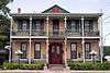 |
June 26, 1986 (#86001373) |
295 E. San Antonio and 165 Market St. 29°42′17″N 98°07′25″W / 29.704722°N 98.123611°W |
New Braunfels | Recorded Texas Historic Landmarks |
| 7 | Comal Power Plant | 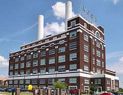 |
August 20, 2004 (#04000895) |
Jct. of Landa Rd. and Landa Park Dr. 29°42′23″N 98°07′57″W / 29.706389°N 98.132431°W |
New Braunfels | |
| 8 | Faust Street Bridge | 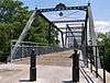 |
March 17, 2009 (#09000138) |
Connecting Faust and Porter Streets at the Guadalupe River 29°41′48″N 98°06′25″W / 29.696667°N 98.106944°W |
New Braunfels | Recorded Texas Historic Landmark, Historic Bridges of Texas MPS |
| 9 | First Protestant Church | .jpg) |
July 14, 1971 (#71000926) |
296 S. Seguin St. 29°42′03″N 98°07′21″W / 29.700833°N 98.1225°W |
New Braunfels | Recorded Texas Historic Landmark |
| 10 | Fischer Historic District | .jpg) |
June 19, 2017 (#100001222) |
Roughly bounded by Fischer Store Rd., FM 32, Patriotic & Let's Roll Drs. 29°58′43″N 98°15′53″W / 29.978527°N 98.264641°W |
Fischer | Includes Recorded Texas Historic Landmark |
| 11 | Carl W. A. Groos House | 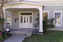 |
August 17, 2000 (#00000884) |
228 S. Seguin St. 29°42′05″N 98°07′22″W / 29.70125°N 98.122708°W |
New Braunfels | Recorded Texas Historic Landmark |
| 12 | Gruene Historic District | .jpg) |
April 21, 1975 (#75001962) |
Both sides of Seguin, New Braunfels, and Austin Sts. 29°44′20″N 98°06′12″W / 29.738889°N 98.103333°W |
Gruene | Includes Recorded Texas Historic Landmarks |
| 13 | Guadalupe Hotel | 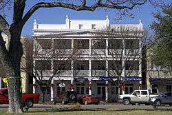 |
March 13, 1975 (#75001963) |
471 Main Plaza 29°42′11″N 98°07′31″W / 29.702986°N 98.125278°W |
New Braunfels | Recorded Texas Historic Landmark |
| 14 | Holz-Forshage-Krueger Building | 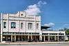 |
April 17, 1997 (#97000362) |
472 W. San Antonio St. 29°41′58″N 98°07′40″W / 29.699444°N 98.127778°W |
New Braunfels | |
| 15 | Honey Creek Historic District | March 26, 2018 (#100002267) |
Along State Park 31 & Bell Ranch Rd., Parcels 77128, 82609, 73632, 77109, 77257, 80607, 81637, 149474 29°50′21″N 98°30′50″W / 29.839032°N 98.513871°W |
Spring Branch | ||
| 16 | Hotel Faust | .jpg) |
May 2, 1985 (#85000922) |
240 S. Seguin St. 29°42′05″N 98°07′23″W / 29.701389°N 98.122917°W |
New Braunfels | Recorded Texas Historic Landmark |
| 17 | Stephen Klein House | 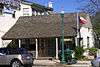 |
August 25, 1970 (#70000743) |
161 S. Seguin St. 29°42′10″N 98°07′26″W / 29.702639°N 98.12375°W |
New Braunfels | Recorded Texas Historic Landmark |
| 18 | Lindheimer House | 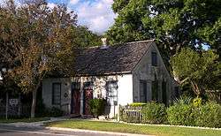 |
August 25, 1970 (#70000744) |
489 Comal Ave. 29°42′02″N 98°07′06″W / 29.700556°N 98.118472°W |
New Braunfels | Recorded Texas Historic Landmark |
| 19 | Natural Bridge Caverns Sinkhole Site |  |
October 29, 2004 (#04001202) |
Address restricted[6] |
Garden Ridge | Located within Natural Bridge Caverns National Natural Landmark |
| 20 | Riley's Tavern | .jpg) |
April 23, 2018 (#100002346) |
8894 FM 1102 29°48′23″N 98°01′25″W / 29.806258°N 98.023601°W |
New Braunfels | |
| 21 | Saint Joseph's Chapel | 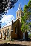 |
August 1, 2014 (#14000472) |
6400 FM 482 29°38′50″N 98°13′09″W / 29.647253°N 98.219029°W |
Schertz | |
| 22 | Walzem Homestead | February 2, 2018 (#100002086) |
690 Mission Valley Rd. 29°43′26″N 98°11′49″W / 29.723768°N 98.197027°W |
New Braunfels |
See also
References
- ↑ "National Register of Historic Places: Weekly List Actions". National Park Service, United States Department of the Interior. Retrieved on October 11, 2018.
- ↑ The latitude and longitude information provided in this table was derived originally from the National Register Information System, which has been found to be fairly accurate for about 99% of listings. For about 1% of NRIS original coordinates, experience has shown that one or both coordinates are typos or otherwise extremely far off; some corrections may have been made. A more subtle problem causes many locations to be off by up to 150 yards, depending on location in the country: most NRIS coordinates were derived from tracing out latitude and longitudes from USGS topographical quadrant maps created under the North American Datum of 1927, which differs from the current, highly accurate WGS84 GPS system used by most on-line maps. Chicago is about right, but NRIS longitudes in Washington are higher by about 4.5 seconds, and are lower by about 2.0 seconds in Maine. Latitudes differ by about 1.0 second in Florida. Some locations in this table may have been corrected to current GPS standards.
- ↑ Numbers represent an ordering by significant words. Various colorings, defined here, differentiate National Historic Landmarks and historic districts from other NRHP buildings, structures, sites or objects.
- ↑ National Park Service (2010-07-09). "National Register Information System". National Register of Historic Places. National Park Service.
- ↑ The eight-digit number below each date is the number assigned to each location in the National Register Information System database, which can be viewed by clicking the number.
- ↑ Federal and state laws and practices restrict general public access to information regarding the specific location of this resource. In some cases, this is to protect archeological sites from vandalism, while in other cases it is restricted at the request of the owner. See: Knoerl, John; Miller, Diane; Shrimpton, Rebecca H. (1990), Guidelines for Restricting Information about Historic and Prehistoric Resources, National Register Bulletin (29), National Park Service, U.S. Department of the Interior, OCLC 20706997 .
External links
![]()
Places adjacent to National Register of Historic Places listings in Comal County, Texas | ||||||||||
|---|---|---|---|---|---|---|---|---|---|---|
| ||||||||||


Municipalities and communities of Comal County, Texas, United States | ||
|---|---|---|
| Cities | | |
| CDP | ||
| Unincorporated communities | ||
| Ghost town | ||
| Footnotes | ‡This populated place also has portions in an adjacent county or counties | |