Clark County, Nevada
| Clark County, Nevada | ||
|---|---|---|
| County | ||
| Clark County | ||
.jpg) | ||
| ||
| Motto: "Living Relentlessly, Developing Economically!" | ||
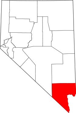 Location in the U.S. state of Nevada | ||
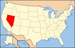 Nevada's location in the U.S. | ||
| Founded | July 1, 1909[1] | |
| Named for | William A. Clark | |
| Seat | Las Vegas | |
| Largest city | Las Vegas | |
| Area | ||
| • Total | 8,061 sq mi (20,878 km2) | |
| • Land | 7,891 sq mi (20,438 km2) | |
| • Water | 169 sq mi (438 km2), 2.1% | |
| Population (est.) | ||
| • (2017) | 2,204,079 | |
| • Density | 279/sq mi (108/km2) | |
| Congressional districts | 1st, 3rd, 4th | |
| Time zone | Pacific: UTC−8/−7 | |
| Website |
www | |
Clark County is located in the U.S. state of Nevada. As of the 2010 U.S. Census, the population was 1,951,269, with an estimated population of 2,204,079 in 2017.[2] It is by far the most populous county in Nevada, accounting for nearly three-quarters of its residents–thus making Nevada one of the most centralized states in the nation.
Las Vegas, the state’s most populous city, has been the county seat since the county’s establishment. The county was formed by the Nevada Legislature by splitting off a portion of Lincoln County on February 5, 1909,[3] and came into existence on July 1, 1909.[4] The Las Vegas Valley, a 600 sq mi (1,600 km2) basin, includes Las Vegas as well as other major cities and communities such as North Las Vegas, Henderson, and the unincorporated community of Paradise.
Much of the county was part of Pah-Ute County, Arizona Territory before Nevada became a state. The county was named for William Andrews Clark, a Montana copper magnate and U.S. Senator. Clark was largely responsible for the construction of the Los Angeles and Salt Lake Railroad through the area, a factor heavily contributing to the region's early development. Clark County is a major tourist destination, with 150,000 hotel rooms. The Las Vegas Strip, home to most of the hotel-casinos known to many around the world, is not within the City of Las Vegas city limits, but in unincorporated Paradise. It is, however, in the Las Vegas Valley.
Clark County is coextensive with the Las Vegas–Paradise, NV Metropolitan Statistical Area, a metropolitan statistical area designated by the Office of Management and Budget and used by the United States Census Bureau and other agencies for statistical purposes.[5]
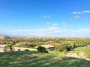
Geography

According to the United States Census Bureau, the county has an area of 8,061 square miles (20,880 km2), of which 7,891 square miles (20,440 km2) is land and 169 square miles (440 km2) (2.1%) is water.[6]
The Colorado River forms the county's southeastern boundary, with Hoover Dam forming Lake Mead along much of its length. The lowest point in the state of Nevada is on the Colorado River just south of Laughlin in Clark County, where it flows out of Nevada into California and Arizona. By definition, Greater Las Vegas is a tectonic valley, surrounded by four mountain ranges, with nearby Mount Charleston being the highest elevation at 11,918 ft (3,633 m), located to the northwest. Other than the forests on Mount Charleston, the geography in Clark County is a desert. Creosote bushes are the main native vegetation, and the mountains are mostly rocky with little vegetation.
Adjacent counties
- Lincoln County – north
- Mohave County, Arizona – east/Mountain Time Border
- San Bernardino County, California – south
- Inyo County, California – southwest
- Nye County – west
National protected areas
- Desert National Wildlife Refuge (part)
- Humboldt-Toiyabe National Forest (part)
- Lake Mead National Recreation Area (part)
- Moapa Valley National Wildlife Refuge
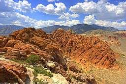
- Red Rock Canyon National Conservation Area
- Sloan Canyon National Conservation Area
- Spring Mountains National Recreation Area (part)
- Toiyabe National Forest (part)
- Tule Springs Fossil Beds National Monument (part)
20 official wilderness areas in Clark County are part of the National Wilderness Preservation System. Many of these are in, or partially in, one of the preceding protected areas, as shown below. Many are separate entities that are managed by the Bureau of Land Management (BLM):
- Arrow Canyon Wilderness (BLM)
- Black Canyon Wilderness (Nevada) (Lake Mead NRA)
- Bridge Canyon Wilderness (Lake Mead NRA)
- Eldorado Wilderness (Lake Mead NRA / BLM)
- Ireteba Peaks Wilderness (Lake Mead NRA / BLM)
- Jimbilnan Wilderness (Lake Mead NRA)
- Jumbo Springs Wilderness (BLM)
- La Madre Mountain Wilderness (BLM / Toiyabe NF)
- Lime Canyon Wilderness (BLM)
- Meadow Valley Range Wilderness (BLM) mostly in Lincoln County, NV
- Mormon Mountains Wilderness (BLM) mostly in Lincoln County, NV
- Mount Charleston Wilderness (Toiyabe NF / BLM)
- Muddy Mountains Wilderness (BLM / Lake Mead NRA)
- Nellis Wash Wilderness (Lake Mead NRA)
- North McCullough Wilderness (part of Sloan Canyon NCA, which is managed by BLM)
- Pinto Valley Wilderness (Lake Mead NRA)
- Rainbow Mountain Wilderness (BLM / Toiyabe NF)
- South McCullough Wilderness (BLM)
- Spirit Mountain Wilderness (Lake Mead NRA / BLM)
- Wee Thump Joshua Tree Wilderness (BLM)
Demographics
| Historical population | |||
|---|---|---|---|
| Census | Pop. | %± | |
| 1910 | 3,321 | — | |
| 1920 | 4,859 | 46.3% | |
| 1930 | 8,532 | 75.6% | |
| 1940 | 16,414 | 92.4% | |
| 1950 | 48,289 | 194.2% | |
| 1960 | 127,016 | 163.0% | |
| 1970 | 273,288 | 115.2% | |
| 1980 | 463,087 | 69.5% | |
| 1990 | 741,459 | 60.1% | |
| 2000 | 1,375,765 | 85.5% | |
| 2010 | 1,951,269 | 41.8% | |
| Est. 2017 | 2,204,079 | [2] | 13.0% |
| U.S. Decennial Census[7] 1790–1960[8] 1900–1990[9] 1990–2000[10] 2010–2016[2] | |||
.png)
2000 census
In 2000 there were 512,253 households out of which 31.70% had children under the age of 18 living with them, 48.70% were married couples living together, 11.80% had a female householder with no husband present, and 33.70% were non-families. 24.50% of all households were made up of individuals and 6.70% had someone living alone who was 65 years of age or older. The average household size was 2.65 and the average family size was 3.17.
In the county, the population was spread out with 25.60% under the age of 18, 9.20% from 18 to 24, 32.20% from 25 to 44, 22.30% from 45 to 64, and 10.70% who were 65 years of age or older. The median age was 34 years. For every 100 females there were 103.50 males. For every 100 females age 18 and over, there were 102.80 males.
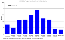
The median income for a household in the county was $53,536, and the median income for a family was $59,485.[13] Males had a median income of $35,243 versus $27,077 for females. The per capita income for the county was $21,785. About 7.90% of families and 10.80% of the population were below the poverty line, including 14.10% of those under age 18 and 7.30% of those age 65 or over.
The United States Census Bureau 2009 estimates place the population for the Las Vegas Metropolitan Statistical Area at 1,902,834 people, and the region is one of the fastest growing in the United States.[14] Large numbers of new residents in the state originate from California.[15]
2010 census
As of the 2010 United States Census, there were 1,951,269 people, 715,365 households, and 467,916 families residing in the county.[16] The population density was 247.3 inhabitants per square mile (95.5/km2). There were 840,343 housing units at an average density of 106.5 per square mile (41.1/km2).[17] The racial makeup of the county was 60.9% white, 10.5% black or African American, 8.7% Asian, 0.7% Pacific islander, 0.7% American Indian, 13.5% from other races, and 5.1% from two or more races. Those of Hispanic or Latino origin made up 29.1% of the population.[16] In terms of ancestry, 11.7% were German, 9.1% were Irish, 7.6% were English, 6.3% were Italian, and 2.7% were American.[18]
Of the 715,365 households, 34.9% had children under the age of 18 living with them, 45.0% were married couples living together, 13.5% had a female householder with no husband present, 34.6% were non-families, and 25.3% of all households were made up of individuals. The average household size was 2.70 and the average family size was 3.26. The median age was 35.5 years.[16]
The median income for a household in the county was $56,258 and the median income for a family was $63,888. Males had a median income of $43,693 versus $35,324 for females. The per capita income for the county was $27,422. About 8.7% of families and 11.7% of the population were below the poverty line, including 16.9% of those under age 18 and 7.6% of those age 65 or over.[19]
Law and government
Clark County Government is run by the Clark County Commission which consists of seven members who are elected to serve staggered four-year terms in biannual partisan elections.
After each election, the members elect a chairman who runs the commission meetings. A county manager hired by the commission handles day-to-day operations. Its unincorporated towns also have appointed boards that provide advice to the commission.
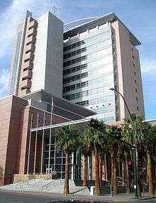
The county operates out of the Clark County Government Center in the City of Las Vegas. The building is unusual in shape, and includes an outdoor amphitheater for concerts and other events.
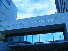
The Las Vegas Metropolitan Police Department provides most law enforcement services in the county, including operation of the county's central jail, the Clark County Detention Center (CCDC). The present department was created in 1973 when the Clark County Sheriff's Department merged with the Las Vegas Police Department.
Other entities with police forces include University of Nevada, Las Vegas, the Clark County School District, and cities such as Henderson, Mesquite, Boulder City and North Las Vegas. The Clark County Park Police is responsible for all of the parks operated by the county and some selected special venues, such as the Clark County Amphitheater, Clark County Archery Range, and the Desert Rose Golf Course.
The Regional Justice Center replaced the Clark County Courthouse in 2005, and is about 3 blocks from downtown Fremont Street, at 200 Lewis Avenue.
Politics
| Year | Republican | Democratic | Third parties |
|---|---|---|---|
| 2016 | 41.7% 320,057 | 52.4% 402,227 | 5.9% 44,872 |
| 2012 | 41.8% 289,053 | 56.4% 389,936 | 1.8% 12,201 |
| 2008 | 39.5% 257,078 | 58.5% 380,765 | 2.1% 13,329 |
| 2004 | 46.8% 255,337 | 51.7% 281,767 | 1.5% 8,293 |
| 2000 | 44.7% 170,932 | 51.3% 196,100 | 4.0% 15,166 |
| 1996 | 39.4% 103,431 | 48.7% 127,963 | 11.9% 31,316 |
| 1992 | 32.2% 97,403 | 41.2% 124,586 | 26.7% 80,793 |
| 1988 | 56.4% 108,110 | 40.9% 78,359 | 2.8% 5,310 |
| 1984 | 62.6% 94,133 | 35.5% 53,386 | 1.9% 2,844 |
| 1980 | 59.8% 76,194 | 30.1% 38,313 | 10.1% 12,917 |
| 1976 | 46.9% 48,236 | 49.8% 51,178 | 3.3% 3,398 |
| 1972 | 59.1% 53,101 | 40.9% 36,807 | |
| 1968 | 42.0% 31,522 | 44.3% 33,225 | 13.8% 10,318 |
| 1964 | 37.0% 23,921 | 63.0% 40,760 | |
| 1960 | 43.2% 18,197 | 56.8% 23,949 | |
| 1956 | 49.3% 18,584 | 50.7% 19,095 | |
| 1952 | 52.9% 13,333 | 47.1% 11,855 | |
| 1948 | 36.6% 6,382 | 61.8% 10,787 | 1.6% 284 |
| 1944 | 38.2% 4,543 | 61.8% 7,350 | |
| 1940 | 29.6% 2,170 | 70.4% 5,154 | |
| 1936 | 18.8% 1,178 | 81.2% 5,091 | |
| 1932 | 18.8% 1,347 | 81.3% 5,837 | |
| 1928 | 56.6% 1,284 | 43.4% 984 | |
| 1924 | 32.6% 533 | 17.6% 288 | 49.8% 815 |
| 1920 | 44.6% 589 | 47.0% 620 | 8.4% 111 |
| 1916 | 28.6% 529 | 60.2% 1,115 | 11.3% 209 |
| 1912 | 13.1% 110 | 42.8% 358 | 44.1% 369[21] |
Regional agencies
The Clark County Regional Flood Control District (CCRFCD) was created in 1985 by the Nevada Legislature allowing Clark County to provide broad solutions to flooding problems.
The Regional Transportation Commission of Southern Nevada operates the RTC Transit system, and does planning for most major roadways.
The Southern Nevada Water Authority is a multi-agency group that manages the water distribution for the Las Vegas Valley.
The Las Vegas Wash Coordination Committee manages and protects the Las Vegas Wash.
Since 1999 the group has added more the 15,000 plants to stabilize the wash's banks and restore and expand the wetlands surrounding the wash. As part of the effort to restore the wash to a more natural state, they have removed more than 500,000 pounds (230,000 kg) of trash.
State government
The Grant Sawyer State Office Building, which houses many branches of state government, is within the City of Las Vegas.[22]
The Nevada Department of Corrections operates three prisons within Clark County. High Desert State Prison, a medium-maximum prison, and the Southern Desert Correctional Center, a medium security prison, are both near Indian Springs, Nevada.[23]
The Florence McClure Women's Correctional Center is in North Las Vegas. The facility, originally the Southern Nevada Women's Correctional Facility opened September 1, 1997. It was built and operated by Corrections Corporation of America. On October 1, 2004, the Department of Corrections took direct control of the facility.[24] It houses the female death row.[25]
Transportation
Major highways
.svg.png)
.svg.png)
.svg.png)
.svg.png)


- Summerlin Parkway
Education
The Clark County School District serves all of Clark County with 228 elementary schools, 59 middle schools, and 54 high schools being the fifth largest in the country. Current enrollment of students as of 2013 was 312,892.
Colleges serving the area are University of Nevada, Las Vegas (UNLV), College of Southern Nevada, and Nevada State College.
Parks and recreation

- Sunset Park, at Sunset Road and Eastern Avenue in Las Vegas
Gaming areas
The State of Nevada divides the state into several gaming districts. The reporting districts affecting Clark County are:[26][27]
- Boulder Strip: This region includes 33 casinos on Boulder Highway. Casinos within the Henderson city limits are included as well, such as Green Valley Ranch, Sunset Station, Fiesta, Eldorado, and Jokers Wild.
- Downtown: There are 19 casinos in this reporting area.
- LV Strip: This region is composed of all the casinos on Las Vegas Boulevard, from The Stratosphere at the north end to Mandalay Bay on the south end. Also included are resorts near this area, such as The Rio, South Point, and the Hard Rock; and McCarran Airport.
- North Las Vegas: This region has 11 casinos and include the Fiesta Rancho, Texas Station, Jerry's Nugget, and the Santa Fe Station.
- Laughlin: The casinos in Laughlin.
- Mesquite: The casinos in Mesquite.
- Balance of County: There are 66 casinos in this category that includes casinos at Lake Las Vegas, Jean, Primm, the Railroad Pass and Hacienda casinos, along with other casinos that don't fit any other category such as Arizona Charlie's Decatur, Gold Coast, The Orleans, The Palms, Suncoast, Rampart, and Red Rock Resort Spa and Casino
Environmental factors
Clark County has a diverse desert flora and fauna, including higher elevation mountain areas, the desert floor and the Colorado River/Lake Mead ecosystems. Variations in diurnal temperature as well as seasonal swings in temperature create demanding adaptation elements on the species of this county. Population expansion, especially since 1970, has placed additional pressure on species in the area.
Correspondingly air quality levels prior to the 1960s were in a favorable range, but the proliferation of automobiles with the human population expansion created circumstances where some Federal Air Quality Standards began to be violated in the 1980s.
To plan for the wave of development forecast by 1980, Clark County embarked on a regional Environmental Impact Assessment funded by a Federal Section 208 program, with Sedway Cooke conducting the planning work and Earth Metrics performing environmental analysis. This endeavor projected population growth, land use changes and environmental impacts.
To prevent the loss of federal funds due to unacceptable dust levels in the Las Vegas valley, in 2003 the Nevada Air Quality Management division (under direction of Clark County officials) created the massive "Don't Be a Dusthole" campaign. The campaign successfully raised awareness of dust pollution in the Las Vegas valley, quantifiably reducing pollutants and preserving ongoing federal funding.[28]
Located in Apex is the Apex Landfill which at 2,200 acres (890 ha) is the largest landfill in the United States.[29] Republic Services owns and operates the landfill.
Earthquake hazards
Nevada is the third most seismically active state in the U.S. (after Alaska and California); it has been estimated by the United States Geological Survey (USGS) that over the next 50 years Clark County has a 10–20% chance of a M6.0 or greater earthquake occurring within 50 km (31 mi) of Las Vegas.[30]
Economy
.jpg)
The county is home to many gaming related companies. Station Casinos is headquartered in unincorporated Clark County, along with[31][32] Golden Entertainment, American Casino & Entertainment Properties, Bally Technologies, Cannery Casino Resorts, The Majestic Star Casino, LLC, Ameristar Casinos, Archon Corporation, Boyd Gaming, Caesars Entertainment, Las Vegas Sands, MGM Resorts International, Wynn Resorts, DBT Online Inc., Gambler's Book Shop / GBC Press, Millennium Management Group, Navegante Group, Pinnacle Entertainment and Tropicana Entertainment
Tourism
The Las Vegas Convention and Visitors Authority post the historical numbers of visitors and hotel rooms in Clark County. The era of massive modern casino resorts began with the opening of the Mirage in November 1989.
Largest employers
According to data collected by the Research and Analysis Bureau of the Nevada Department of Employment, Training and Rehabilitation Clark County's largest employers, both public and private employers, as reported in the fourth quarter of 2012.[33]
30,000 to 39,999 Employees
5,000 to 10,000 Employees
2,500 to 4,999
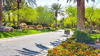
Communities

Bracketed number refers to location on map, right
Cities
- Boulder City (21)
- Henderson (19)
- Las Vegas (10) (county seat)
- North Las Vegas (9)
- Mesquite (4)
Census-designated places
- Blue Diamond (18)
- Bunkerville (5)
- Cal-Nev-Ari (23)
- Enterprise (17)
- Goodsprings (20)
- Indian Springs (6)
- Laughlin (24)
- Moapa Town (1)
- Moapa Valley (3)
- Mount Charleston (7)
- Nelson
- Paradise (15)
- Sandy Valley (16)
- Searchlight (22)
- Spring Valley (13)
- Summerlin South (12)
- Sunrise Manor (11)
- Whitney (formerly East Las Vegas) (26)
- Winchester (14)
Air Force bases
Other unincorporated communities
- Arden
- Cactus Springs
- Cottonwood Cove
- Coyote Springs (planned)
- Crystal
- Fort Mojave Indian Reservation (former CDP) (25)
- Glendale (2)
- Jean
- Logandale
- Las Vegas Indian Colony (8)
- Mountain Springs
- Overton
- Primm
- Roach
- Sloan
- Summerlin
- Sutor
- Vegas Creek (former CDP)
Notable government buildings
- Clark County Government Center
- Regional Justice Center (opened October 3, 2005)
See also
References
- ↑ "A Timeline Of Clark County History" (PDF). Retrieved 2016-01-01.
- 1 2 3 "American Factfinder". United States Census Bureau. Retrieved 2018-04-24.
- ↑ Las Vegas Sun, January 4, 2009; Joseph Nathan Kane, The American Counties (4th Ed.), (The Scarecrow Press, 1983), p479-480
- ↑ Squires, C. P. Sam P. Davis, ed. The History of Nevada. Nevada's Online State News Journal. p. 801. Archived from the original on July 20, 2009. Retrieved July 25, 2009.
- ↑ "Metropolitan Statistical Areas and Components, December 2005, with codes". Archived from the original on February 9, 2006. Retrieved March 23, 2007.
- ↑ "2010 Census Gazetteer Files". United States Census Bureau. August 22, 2012. Retrieved December 20, 2014.
- ↑ "U.S. Decennial Census". United States Census Bureau. Archived from the original on May 12, 2015. Retrieved December 20, 2014.
- ↑ "Historical Census Browser". University of Virginia Library. Retrieved December 20, 2014.
- ↑ "Population of Counties by Decennial Census: 1900 to 1990". United States Census Bureau. Retrieved December 20, 2014.
- ↑ "Census 2000 PHC-T-4. Ranking Tables for Counties: 1990 and 2000" (PDF). United States Census Bureau. Retrieved December 20, 2014.
- ↑ "Household Income Distribution in Las Vegas". American Fact Finder. US Census Breau. Retrieved May 4, 2018.
- ↑ "POVERTY STATUS IN THE PAST 12 MONTHS". American Fact Finder. US Census Breau. Retrieved April 9, 2018.
- ↑ "Clark County, Nevada – Income in the Past 12 Months (In 2006 Inflation-Adjusted Dollars)". Factfinder.census.gov. Archived from the original on February 26, 2009. Retrieved 2013-05-04.
- ↑ "Estimates of Population Change for Metropolitan Statistical Areas and Rankings: July 1, 2008 to July 1, 2009". U.S. Census Bureau. April 2009. Archived from the original on June 15, 2010. Retrieved October 26, 2010.
- ↑ "About.com". Usgovinfo.about.com. June 19, 2010. Retrieved 2011-02-20.
- 1 2 3 "DP-1 Profile of General Population and Housing Characteristics: 2010 Demographic Profile Data". United States Census Bureau. Retrieved 2016-01-21.
- ↑ "Population, Housing Units, Area, and Density: 2010 – County". United States Census Bureau. Retrieved 2016-01-21.
- ↑ "DP02 SELECTED SOCIAL CHARACTERISTICS IN THE UNITED STATES – 2006–2010 American Community Survey 5-Year Estimates". United States Census Bureau. Retrieved 2016-01-21.
- ↑ "DP03 SELECTED ECONOMIC CHARACTERISTICS – 2006–2010 American Community Survey 5-Year Estimates". United States Census Bureau. Retrieved 2016-01-21.
- ↑ Leip, David. "Dave Leip's Atlas of U.S. Presidential Elections". uselectionatlas.org. Retrieved 2018-04-12.
- ↑ The leading "other" candidate, Progressive Theodore Roosevelt, received 261 votes, while Socialist candidate Eugene Debs received 108 votes.
- ↑ "State Agencies and Departments". Nv.gov. Retrieved 2016-01-01.
- ↑ "Facilities | Nevada Department of Corrections". Doc.nv.gov. Retrieved 2016-01-01.
- ↑ "." Nevada Department of Corrections. Retrieved on January 6, 2010.
- ↑ "Lone woman on Nevada's death row dies in prison ." Associated Press at North County Times. January 31, 2005. Retrieved on September 5, 2010.
- ↑ "Abbreviated Revenue Release Index". Nevada Gaming Control Board. Archived from the original on August 20, 2008. Retrieved 2009-05-03.
- ↑ "February 2009 Nevada Gaming Revenues and Collections" (PDF). Nevada Gaming Control Board (Press release). April 7, 2009. Archived from the original (PDF) on February 17, 2012. Retrieved 2009-05-03.
- ↑ "– News – Dusty the Dusthole successful". Reviewjournal.com. Archived from the original on March 24, 2012. Retrieved 2013-05-04.
- ↑ Schoenmann, Joe (December 17, 2008). "Official calls for sort reform". Las Vegas Sun. Retrieved December 20, 2008.
- ↑ "Loss-Estimation Modeling of Earthquake Scenarios for Each County in Nevada Using HAZUS-MH" (PDF). Nevada Bureau of Mines and Geology. Nevada Bureau of Mines and Geology/University of Nevada, Reno. 23 February 2006. Retrieved 27 March 2016.
"Probability of an earthquake of magnitude 6.0 or greater occurring within 50 km in 50 years (from USGS probabilistic seismic hazard analysis) 10–20% chance for Las Vegas area, magnitude 6" (p.65)
- ↑ "Interactive Map Viewer." City of Las Vegas. Retrieved on June 5, 2009.
- ↑ "Map." Station Casinos. Retrieved on June 5, 2009. Archived September 5, 2015, at the Wayback Machine.
- ↑ "Nevada Workforce Informer, Nevada`s Top Employers". Nevadaworkforce.com. Retrieved 2016-01-01.
External links
| Wikimedia Commons has media related to Clark County, Nevada. |
- Official website
- Clark County Television (County of Clark owned television station with Live Internet Feed)
Coordinates: 36°12′N 115°01′W / 36.20°N 115.02°W
Places adjacent to Clark County, Nevada | |
|---|---|
Municipalities and communities of Clark County, Nevada, United States | ||
|---|---|---|
| Cities | | |
| CDPs | ||
| Unincorporated communities | ||
| Township | ||
| Ghost towns | ||
| Indian reservations | ||
| Footnotes | ‡This populated place also has portions in an adjacent county or counties | |
Carson City (capital) | ||
| Topics |
|  |
| Society | ||
| Regions | ||
| Metro areas | ||
| Counties | ||
| Cities and communities |
| |
| Former counties | ||