Kauai County, Hawaii
| Kauai County, Hawaii | ||
|---|---|---|
 | ||
| ||
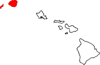 Location in the U.S. state of Hawaii | ||
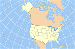 Hawaii's location in the U.S. | ||
| Founded | 1905 | |
| Government • Mayor |
Bernard Carvalho | |
| Seat | Lihue | |
| Largest community | Kapa‘a | |
| Area | ||
| • Total | 1,266 sq mi (3,279 km2) | |
| • Land | 620 sq mi (1,606 km2) | |
| • Water | 646 sq mi (1,673 km2), 51.0% | |
| Population (est.) | ||
| • (2016) | 72,029 | |
| • Density | 108/sq mi (42/km2) | |
| Congressional district | 2nd | |
| Time zone | Hawaii–Aleutian: UTC−10 | |
| Website |
www | |
Kauaʻi County is a county in the U.S. state of Hawaiʻi. It consists of the islands of Kauaʻi, Niʻihau, Lehua, and Kaʻula. As of the 2010 Census the population was 67,091.[1] The county seat is Līhuʻe.[2]
The Kapa'a Micropolitan Statistical Area includes all of Kauai County.
Geography
According to the U.S. Census Bureau, the county has a total area of 1,266 square miles (3,280 km2), of which 620 square miles (1,600 km2) is land and 646 square miles (1,670 km2) (51.0%) is water.[3] The Pacific Ocean surrounds the county.
Adjacent County
- Honolulu County, Hawaii - southeast
National protected areas
Government and Politics
Kauaʻi County has a mayor-council form of municipal government. Executive authority is vested in the Mayor of Kauaʻi, elected by the voters on a nonpartisan basis to a four-year term. Legislative authority is vested in the seven-member County Council. All members of the County Council are elected on a nonpartisan, at-large basis to two-year terms.
United States Congress
Kauai County, like the rest of Hawaii, is represented entirely by Democrats in both the United States Senate and the United States House of Representatives.
| Senators | Name | Party | First Elected | Level | |
|---|---|---|---|---|---|
| Senate Class 1 | Mazie Hirono | Democratic | 2013 | Junior Senator | |
| Senate Class 3 | Brian Schatz | Democratic | 2012 | Senior Senator | |
| Representatives | Name | Party | First Elected | Area(s) of Kauai County Represented | |
| District 2 | Tulsi Gabbard | Democratic | 2013 | entire county | |
Hawaii Legislature
Hawaii Senate
| District | Name | Party | First Elected | Area(s) of Kaua'i County Represented | |
|---|---|---|---|---|---|
| 8 | Ron Kouchi | Democratic | 2010 | entire county | |
Hawaii House of Representatives
| District | Name | Party | First Elected | Area(s) of Kaua'i County Represented | |
|---|---|---|---|---|---|
| 14 | Nadine Nakamura | Democratic | 2016 | Hanalei, Princeville, Kīlauea, Anahola, Kapa'a, Wailua | |
| 15 | James Tokioka | Democratic | 2007 | Wailuā Homesteads, Hanamā'ulu, Līhu'e, Puhi, Kōloa, 'Ōma'o | |
| 16 | Dee Morikawa | Democratic | 2011 | Ni'ihau, Lehua, Kōloa, Waimea | |
Elections
Federal
Kauai County has traditionally been a solid Democratic stronghold. The county has not voted Republican since the 1984 federal election, when it narrowly voted in favor of Ronald Reagan.
| Year | Republican | Democratic | Others |
|---|---|---|---|
| 2016 | 28.8% 7,574 | 62.5% 16,456 | 8.7% 2,305 |
| 2012 | 24.1% 6,121 | 73.5% 18,641 | 2.4% 610 |
| 2008 | 22.9% 6,245 | 75.0% 20,416 | 2.1% 563 |
| 2004 | 39.2% 9,740 | 60.0% 14,916 | 0.9% 220 |
| 2000 | 30.2% 6,583 | 61.9% 13,470 | 7.9% 1,720 |
| 1996 | 25.3% 5,325 | 63.5% 13,357 | 11.1% 2,338 |
| 1992 | 32.8% 6,274 | 56.0% 10,715 | 11.2% 2,138 |
| 1988 | 41.0% 8,298 | 58.1% 11,770 | 1.0% 198 |
| 1984 | 50.5% 9,249 | 48.3% 8,862 | 1.2% 221 |
| 1980 | 35.4% 5,883 | 54.6% 9,081 | 10.0% 1,657 |
| 1976 | 43.2% 6,278 | 55.8% 8,105 | 1.0% 139 |
| 1972 | 58.4% 7,571 | 41.6% 5,401 | |
| 1968 | 36.5% 4,140 | 62.2% 7,051 | 1.4% 155 |
| 1964 | 18.5% 1,971 | 81.6% 8,713 | |
| 1960 | 55.0% 5,655 |
Demographics
| Historical population | |||
|---|---|---|---|
| Census | Pop. | %± | |
| 1900 | 20,734 | — | |
| 1910 | 23,952 | 15.5% | |
| 1920 | 29,438 | 22.9% | |
| 1930 | 35,942 | 22.1% | |
| 1940 | 35,818 | −0.3% | |
| 1950 | 29,905 | −16.5% | |
| 1960 | 28,176 | −5.8% | |
| 1970 | 29,761 | 5.6% | |
| 1980 | 39,082 | 31.3% | |
| 1990 | 51,177 | 30.9% | |
| 2000 | 58,463 | 14.2% | |
| 2010 | 67,091 | 14.8% | |
| Est. 2016 | 72,029 | [5] | 7.4% |
| U.S. Decennial Census[6] 1790-1960[7] 1900-1990[8] 1990-2000[9] 2010-2016[1] | |||
As of the census[10] of 2000, there were 58,463 people, 20,183 households, and 14,572 families residing in the county. The population density was 94 people per square mile (36/km²). There were 25,331 housing units at an average density of 41 per square mile (16/km²). The racial makeup of the county was 29.5% White, 0.3% Black or African American, 0.4% Native American, 36.0% Asian, 9.1% Pacific Islander, 0.9% from other races, and 23.8% from two or more races. 8.2% of the population were Hispanic or Latino of any race.
There were 20,183 households out of which 34.0% had children under the age of 18 living with them, 53.9% were married couples living together, 12.8% had a female householder with no husband present, and 27.8% were non-families. 21.4% of all households were made up of individuals and 7.7% had someone living alone who was 65 years of age or older. The average household size was 2.87 and the average family size was 3.34.
In the county, the population was spread out with 26.4% under the age of 18, 7.1% from 18 to 24, 27.2% from 25 to 44, 25.5% from 45 to 64, and 13.8% who were 65 years of age or older. The median age was 38 years. For every 100 females there were 100.10 males. For every 100 females age 18 and over, there were 97.50 males.
Economy
Top employers
According to the County's 2010 Comprehensive Annual Financial Report,[11] the top non-government employers in the county are:
| # | Employer | # of Employees |
|---|---|---|
| 1 | Grand Hyatt Kauai Resort and Spa | 997 |
| 2 | Kauai Marriott Resort & Beach Club | 564 |
| 3 | Manu Kai (ITT/Ke`aki Technologies joint venture) | 529 |
| 4 | Wilcox Memorial Hospital | 486 |
| 5 | Walmart | 417 |
| 6 | Big Save | 410 |
| 7 | The St. Regis Princeville Resort | 336 |
| 8 | Sheraton Kauai Resort | 309 |
| 9 | Kauai Beach Resort | 250 |
| 10 | Nursefinders | 238 |
Education
Higher education
Kauai Community College is the county's only institution of higher education. One of the ten branches of the University of Hawai'i system, it offers a range of 2-year degrees and is accredited by the Western Association of Schools and Colleges.
Primary and Secondary Education
Public schools in the county are operated by the Hawai'i Department of Education, and the county is represented by Maggie Cox on the state's Board of Education. There are 14 elementary schools, 4 middle schools and 3 high schools in the county.
High Schools
Middle Schools
- Kamakahelei Middle School
- Kapa'a Middle School
- Waimea Canyon Middle School
- Ni'ihau Elementary and Middle School
Elementary Schools
- Eleele Elementary School
- Hanalei Elementary School
- Kalaheo Elementary School
- Kanuikapono PCS
- Kapa'a Elementary
- Kaumualii Elementary School
- Kawaikini NCPS
- Ke Kula Ni'ihau Kekaha PCS
- Kekaha Elementary School
- Kilauea Elementary School
- Kōloa Elementary School
- Kula Aupuni Niʻihau A Kahelelani Aloha
- Wilcox Elementary School
- Ni'ihau Elementary and Middle School
Private Schools
There are two private schools in the county: the Island School, and the Kahili Adventist School.
Transportation
Lihue Airport serves the island of Kauai. Bus service is provided by The Kauai Bus.
Major Highways
Communities
There are no incorporated communities in Kauai County, or in any other county of Hawaii. The county is the only form of local government in the State of Hawaii.
Census-designated places
Other unincorporated place
Sister cities


References
- 1 2 "State & County QuickFacts". United States Census Bureau. Archived from the original on July 13, 2011. Retrieved June 28, 2014.
- ↑ "Find a County". National Association of Counties. Archived from the original on 2011-05-31. Retrieved 2011-06-07.
- ↑ "US Gazetteer files: 2010, 2000, and 1990". United States Census Bureau. 2011-02-12. Retrieved 2011-04-23.
- ↑ Leip, David. "Dave Leip's Atlas of U.S. Presidential Elections". uselectionatlas.org. Retrieved May 26, 2017.
- ↑ "Population and Housing Unit Estimates". Retrieved June 9, 2017.
- ↑ "U.S. Decennial Census". United States Census Bureau. Archived from the original on May 12, 2015. Retrieved June 28, 2014.
- ↑ "Historical Census Browser". University of Virginia Library. Retrieved June 28, 2014.
- ↑ "Population of Counties by Decennial Census: 1900 to 1990". United States Census Bureau. Retrieved June 28, 2014.
- ↑ "Census 2000 PHC-T-4. Ranking Tables for Counties: 1990 and 2000" (PDF). United States Census Bureau. Retrieved June 28, 2014.
- ↑ "American FactFinder". United States Census Bureau. Retrieved 2008-01-31.
- ↑ County of Kauai CAFR Archived 2012-11-06 at the Wayback Machine.
Islands, municipalities, and communities of Kauai County, Hawaii, United States | ||
|---|---|---|
| CDPs | | |
| Unincorporated communities | ||
Honolulu (capital) | ||
| Topics | ||
| Society | ||
| Main islands | ||
| Northwestern Islands | ||
| Communities | ||
| Counties | ||
| Sovereignty Movement | ||