Madera County, California
| Madera County, California | |||
|---|---|---|---|
| County | |||
| County of Madera | |||
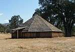 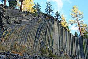 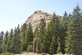  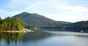 Images, from top down, left to right: Wassama Round House State Historic Park, Devils Postpile National Monument, Fresno Dome, Banner Peak above Thousand Island Lake, Bass Lake | |||
| |||
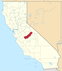 Location in the state of California | |||
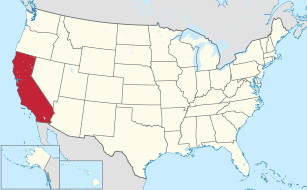 California's location in the United States | |||
| Country |
| ||
| State |
| ||
| Regions | San Joaquin Valley, Sierra Nevada | ||
| Metropolitan area | Metropolitan Fresno | ||
| Incorporated | 1893 | ||
| Named for | Spanish word meaning "wood" | ||
| County seat | Madera | ||
| Area | |||
| • Total | 2,153 sq mi (5,580 km2) | ||
| • Land | 2,137 sq mi (5,530 km2) | ||
| • Water | 16 sq mi (40 km2) | ||
| Population (April 1, 2010)[1] | |||
| • Total | 150,865 | ||
| • Estimate (2016)[2] | 154,697 | ||
| • Density | 70/sq mi (27/km2) | ||
| Time zone | UTC−8 (Pacific Time Zone) | ||
| • Summer (DST) | UTC−7 (Pacific Daylight Time) | ||
| FIPS code | 06-039 | ||
| GNIS feature ID | 277284 | ||
| Website |
www | ||

Madera County, officially the County of Madera, is a county at the geographic center of the U.S. state of California.[3] As of the 2010 census, the population was 150,865.[1] The county seat is Madera.[4]
Madera County comprises the Madera, CA Metropolitan Statistical Area, which is included in the Fresno-Madera, CA Combined Statistical Area. It is located in the eastern San Joaquin Valley and the central Sierra Nevada.
The southeasternmost part of Yosemite National Park is located in the county's northeast.
History
Madera County was formed in 1893 from Fresno County during a special election held in Fresno on May 16, 1893. Citizens residing in the area that was to become Madera County voted 1,179 to 358 for separation from Fresno County and the establishment of Madera County.[5]
Madera is the Spanish term for wood.[6] The county derives its name from the town of Madera, named when the California Lumber Company built a log flume to carry lumber to the Central Pacific Railroad there in 1876.[7]
The Madera County Sheriff's Department employed the first woman in California to die in the line of duty as a sworn law enforcement officer—Tulare native Lucille Helm (1914-1959). For 15 years, the Madera housewife and mother of four worked on call as a "matron" assisting with female transfers.[8]
Geography
According to the U.S. Census Bureau, the county has a total area of 2,153 square miles (5,580 km2), of which 2,137 square miles (5,530 km2) is land and 16 square miles (41 km2) (0.8%) is water.[9]
Madera County is part of the Madera AVA wine region.
National protected areas
Demographics
2011
| Population, race, and income | |||||
|---|---|---|---|---|---|
| Total population[10] | 149,611 | ||||
| White[10] | 121,045 | 80.9% | |||
| Black or African American[10] | 4,962 | 3.3% | |||
| American Indian or Alaska Native[10] | 2,541 | 1.7% | |||
| Asian[10] | 2,980 | 2.0% | |||
| Native Hawaiian or other Pacific Islander[10] | 755 | 0.5% | |||
| Some other race[10] | 12,152 | 8.1% | |||
| Two or more races[10] | 5,176 | 3.5% | |||
| Hispanic or Latino (of any race)[11] | 79,037 | 52.8% | |||
| Per capita income[12] | $18,817 | ||||
| Median household income[13] | $47,724 | ||||
| Median family income[14] | $51,658 | ||||
Places by population, race, and income
| Places by population and race | ||||||||
|---|---|---|---|---|---|---|---|---|
| Place | Type[15] | Population[10] | White[10] | Other[10] [note 1] |
Asian[10] | Black or African American[10] |
Native American[10] [note 2] |
Hispanic or Latino (of any race)[11] |
| Ahwahnee | CDP | 1,685 | 99.9% | 0.0% | 0.1% | 0.0% | 0.0% | 0.1% |
| Bass Lake | CDP | 473 | 96.6% | 0.0% | 0.0% | 0.0% | 3.4% | 3.4% |
| Bonadelle Ranchos-Madera Ranchos | CDP | 8,400 | 83.1% | 8.0% | 3.1% | 5.3% | 0.4% | 26.0% |
| Chowchilla | City | 18,465 | 68.1% | 14.3% | 2.5% | 10.2% | 5.0% | 36.7% |
| Coarsegold | CDP | 1,490 | 98.2% | 1.8% | 0.0% | 0.0% | 0.0% | 4.9% |
| Fairmead | CDP | 1,042 | 77.7% | 17.9% | 0.8% | 3.6% | 0.0% | 53.3% |
| La Vina | CDP | 788 | 100.0% | 0.0% | 0.0% | 0.0% | 0.0% | 100.0% |
| Madera | City | 60,221 | 80.2% | 12.7% | 2.9% | 3.0% | 1.3% | 74.9% |
| Madera Acres | CDP | 9,201 | 80.2% | 14.6% | 0.3% | 2.4% | 2.5% | 63.7% |
| Nipinnawasee | CDP | 644 | 90.1% | 9.9% | 0.0% | 0.0% | 0.0% | 7.1% |
| Oakhurst | CDP | 3,014 | 85.7% | 12.2% | 0.0% | 0.6% | 1.5% | 12.9% |
| Parksdale | CDP | 3,094 | 75.0% | 19.5% | 0.0% | 1.1% | 4.4% | 92.5% |
| Parkwood | CDP | 2,500 | 66.6% | 23.1% | 6.1% | 4.3% | 0.0% | 79.3% |
| Rolling Hills | CDP | 927 | 88.2% | 4.5% | 6.8% | 0.4% | 0.0% | 8.8% |
| Yosemite Lakes | CDP | 4,655 | 94.4% | 2.2% | 1.6% | 0.2% | 1.6% | 12.3% |
| Places by population and income | |||||
|---|---|---|---|---|---|
| Place | Type[15] | Population[16] | Per capita income[12] | Median household income[13] | Median family income[14] |
| Ahwahnee | CDP | 1,685 | $36,369 | $48,289 | $59,063 |
| Bass Lake | CDP | 473 | $53,315 | $77,857 | $78,839 |
| Bonadelle Ranchos-Madera Ranchos | CDP | 8,400 | $29,655 | $74,917 | $83,508 |
| Chowchilla | City | 18,465 | $12,612 | $41,858 | $47,283 |
| Coarsegold | CDP | 1,490 | $31,284 | $40,333 | $63,719 |
| Fairmead | CDP | 1,042 | $16,132 | $42,426 | $41,103 |
| La Vina | CDP | 788 | $7,404 | $27,917 | $28,333 |
| Madera | City | 60,221 | $14,685 | $41,991 | $43,584 |
| Madera Acres | CDP | 9,201 | $20,061 | $63,462 | $66,341 |
| Nipinnawasee | CDP | 644 | $23,104 | $43,083 | $63,447 |
| Oakhurst | CDP | 3,014 | $22,877 | $37,609 | $46,979 |
| Parksdale | CDP | 3,094 | $11,554 | $39,267 | $38,276 |
| Parkwood | CDP | 2,500 | $9,352 | $38,941 | $26,654 |
| Rolling Hills | CDP | 927 | $28,421 | $69,226 | $91,635 |
| Yosemite Lakes | CDP | 4,655 | $34,028 | $77,214 | $79,440 |
2010
| Historical population | |||
|---|---|---|---|
| Census | Pop. | %± | |
| 1900 | 6,364 | — | |
| 1910 | 8,368 | 31.5% | |
| 1920 | 12,203 | 45.8% | |
| 1930 | 17,164 | 40.7% | |
| 1940 | 23,314 | 35.8% | |
| 1950 | 36,964 | 58.5% | |
| 1960 | 40,468 | 9.5% | |
| 1970 | 41,519 | 2.6% | |
| 1980 | 63,116 | 52.0% | |
| 1990 | 88,090 | 39.6% | |
| 2000 | 123,109 | 39.8% | |
| 2010 | 150,865 | 22.5% | |
| Est. 2017 | 156,890 | [2] | 4.0% |
| U.S. Decennial Census[17] 1790–1960[18] 1900–1990[19] 1990–2000[20] 2010–2015[1] | |||
The 2010 United States Census reported that Madera County had a population of 150,865. The racial makeup of Madera County was 94,456 (62.6%) White, 5,629 (3.7%) African American, 4,136 (2.7%) Native American, 2,802 (1.9%) Asian, 162 (0.1%) Pacific Islander, 37,380 (24.8%) from other races, and 6,300 (4.2%) from two or more races. Hispanic or Latino of any race were 80,992 persons (53.7%).[21]
| Population reported at 2010 United States Census | |||||||||
|---|---|---|---|---|---|---|---|---|---|
Population | American | American | Islander | races | more races | or Latino (of any race) | |||
| Madera County | 150,865 | 94,456 | 5,629 | 4,136 | 2,802 | 162 | 37,380 | 6,300 | 80,992 |
city | Population | American | American | Islander | races | more races | or Latino (of any race) | ||
| Chowchilla | 18,720 | 11,533 | 2,358 | 376 | 395 | 37 | 3,313 | 708 | 7,073 |
| Madera | 61,416 | 30,640 | 2,069 | 1,933 | 1,369 | 72 | 22,603 | 2,730 | 47,103 |
place | Population | American | American | Islander | races | more races | or Latino (of any race) | ||
| Ahwahnee | 2,246 | 2,064 | 6 | 30 | 16 | 0 | 38 | 92 | 196 |
| Bass Lake | 527 | 503 | 1 | 10 | 1 | 0 | 2 | 10 | 22 |
| Bonadelle Ranchos-Madera Ranchos | 8,569 | 7,034 | 114 | 120 | 207 | 4 | 811 | 279 | 2,305 |
| Coarsegold | 1,840 | 1,617 | 11 | 50 | 32 | 6 | 47 | 77 | 156 |
| Fairmead | 1,447 | 764 | 88 | 23 | 7 | 0 | 497 | 68 | 984 |
| La Vina | 279 | 117 | 3 | 0 | 0 | 0 | 150 | 9 | 265 |
| Madera Acres | 9,163 | 5,838 | 241 | 161 | 114 | 5 | 2,448 | 356 | 5,985 |
| Nipinnawasee | 475 | 422 | 2 | 9 | 0 | 0 | 3 | 39 | 50 |
| Oakhurst | 2,829 | 2,532 | 22 | 61 | 44 | 3 | 66 | 101 | 473 |
| Parksdale | 2,621 | 1,155 | 56 | 65 | 18 | 3 | 1,231 | 93 | 2,278 |
| Parkwood | 2,268 | 1,138 | 123 | 48 | 22 | 0 | 814 | 123 | 1,784 |
| Rolling Hills | 742 | 642 | 16 | 11 | 25 | 2 | 34 | 12 | 143 |
| Yosemite Lakes | 4,952 | 4,408 | 38 | 91 | 51 | 8 | 131 | 225 | 517 |
communities | Population | American | American | Islander | races | more races | or Latino (of any race) | ||
| All others not CDPs (combined) | 32,771 | 24,049 | 481 | 1,148 | 501 | 22 | 5,192 | 1,378 | 11,658 |
2000

As of the census[22] of 2000, there are 123,109 people in the county, organized into 36,155 households, and 28,598 families. The population density is 58 people per square mile (22/km²). There are 40,387 housing units at an average density of 19 per square mile (7/km²). The racial makeup of the county is 62.2% White, 4.1% Black or African American, 2.6% Native American, 1.3% Asian, 0.2% Pacific Islander, 24.4% from other races, and 5.2% from two or more races. 44.3% of the population are Hispanic or Latino of any race. 8.0% were of German, 5.9% English, 5.4% American and 5.3% Irish ancestry according to Census 2000. 63.6% spoke English and 33.7% Spanish as their first language.
There are 36,155 households out of which 40.2% have children under the age of 18 living with them, 60.9% are married couples living together, 12.2% have a female householder with no husband present, and 20.9% are non-families. 16.5% of all households are made up of individuals and 7.7% have someone living alone who is 65 years of age or older. The average household size is 3.18 and the average family size is 3.52.
In the county, the population is spread out with 29.6% under the age of 18, 9.9% from 18 to 24, 29.1% from 25 to 44, 20.4% from 45 to 64, and 11.0% who are 65 years of age or older. The median age is 33 years. For every 100 females there are 91.8 males. For every 100 females age 18 and over, there are 86.0 males.
The median income for a household in the county is $36,286, and the median income for a family is $39,226. Males have a median income of $33,658 versus $24,415 for females. The per capita income for the county is $14,682. 21.4% of the population and 15.9% of families are below the poverty line. Out of the total population, 28.6% of those under the age of 18 and 9.0% of those 65 and older are living below the poverty line.
Education
Madera County is mostly covered by the State Center Community College District centered on Fresno City College in Fresno. Other districts with terrirtory within Madera County also include the West Hills Community College District and the Merced Community College District.
Government, policing, and politics
Government
The Government of Madera County is mandated by the California Constitution to have a five member Board of Supervisors with elected four year staggered terms. The Board of Supervisors and County Administrator and staff provide for voter registration and elections, law enforcement, jails, vital records, property records, tax collection, public health, roads, and social services for the entire county.. It is the local government for all unincorporated areas. Other elected offices include the Sheriff, District Attorney, Assessor-Recorder, Auditor-Controller/Treasurer-Tax Collector, and Clerk/Registrar of Voters.
Policing
Madera County Sheriff
The sheriff's department and staff provide court protection, jail administration, and coroner service for all of Madera County with its total population of approximately 156,000 residents. The sheriff provides police patrol and detective services to the unincorporated areas of the county which contains approximately 70,000 residents, or 45% of Madera County's total population. The Sheriff's main station and offices are at Madera. There are two sheriff's substations: Oakhurst, population 3,000, and Coarsegold, population 2,000, both on highway 41 to Yosemite National Park in the Sierras.
Municipal police departments
The municipal police departments within Madera County are Madera, the county seat, population 62,000, and Chowchilla, 19,600.
Politics
Voter registration
| Population and registered voters | ||
|---|---|---|
| Total population[10] | 149,611 | |
| Registered voters[23][note 3] | 53,782 | 35.9% |
| Democratic[23] | 18,212 | 33.9% |
| Republican[23] | 23,858 | 44.4% |
| Democratic–Republican spread[23] | -5,646 | -10.5% |
| Independent[23] | 1,615 | 3.0% |
| Green[23] | 208 | 0.4% |
| Libertarian[23] | 264 | 0.5% |
| Peace and Freedom[23] | 131 | 0.2% |
| Americans Elect[23] | 0 | 0.0% |
| Other[23] | 191 | 0.4% |
| No party preference[23] | 9,303 | 17.3% |
Cities by population and voter registration
| Cities by population and voter registration | |||||||
|---|---|---|---|---|---|---|---|
| City | Population[10] | Registered voters[23] [note 3] |
Democratic[23] | Republican[23] | D–R spread[23] | Other[23] | No party preference[23] |
| Chowchilla | 18,465 | 22.5% | 30.8% | 45.1% | -14.3% | 9.0% | 18.8% |
| Madera | 60,221 | 26.8% | 44.9% | 33.1% | +11.8% | 6.2% | 18.4% |
Overview
Madera is a strongly Republican county in Presidential and congressional elections. The last Democrat to win a majority in the county was Jimmy Carter in 1976.
| Year | GOP | DEM | Others |
|---|---|---|---|
| 2016 | 53.69% 23,357 | 39.14% 17,029 | 7.17% 3,121 |
| 2012 | 57.23% 22,852 | 40.11% 16,018 | 2.66% 1,063 |
| 2008 | 55.52% 23,583 | 42.27% 17,952 | 2.21% 939 |
| 2004 | 64.02% 24,871 | 34.70% 13,481 | 1.28% 498 |
| 2000 | 60.74% 20,283 | 34.89% 11,650 | 4.37% 1,462 |
| 1996 | 53.85% 16,510 | 36.70% 11,254 | 9.45% 2,898 |
| 1992 | 43.20% 13,066 | 35.92% 10,863 | 20.88% 6,316 |
| 1988 | 54.59% 13,255 | 43.83% 10,642 | 1.58% 384 |
| 1984 | 60.04% 13,954 | 38.70% 8,994 | 1.26% 293 |
| 1980 | 53.58% 10,599 | 39.35% 7,783 | 7.07% 1,398 |
| 1976 | 45.96% 6,844 | 51.20% 7,625 | 2.84% 423 |
| 1972 | 52.61% 7,835 | 44.18% 6,580 | 3.20% 477 |
| 1968 | 43.55% 6,229 | 48.47% 6,932 | 7.98% 1,142 |
| 1964 | 32.18% 4,461 | 67.75% 9,391 | 0.07% 10 |
| 1960 | 41.75% 5,869 | 57.81% 8,126 | 0.44% 62 |
| 1956 | 42.12% 5,239 | 57.58% 7,162 | 0.31% 38 |
| 1952 | 49.67% 6,278 | 49.40% 6,244 | 0.93% 118 |
| 1948 | 38.03% 3,416 | 58.18% 5,226 | 3.79% 340 |
| 1944 | 39.85% 2,865 | 59.47% 4,276 | 0.68% 49 |
| 1940 | 31.20% 2,653 | 67.61% 5,749 | 1.19% 101 |
| 1936 | 22.61% 1,387 | 75.74% 4,646 | 1.65% 101 |
| 1932 | 25.22% 1,243 | 70.15% 3,457 | 4.63% 228 |
| 1928 | 54.88% 2,354 | 44.21% 1,896 | 0.91% 39 |
| 1924 | 42.66% 1,518 | 12.65% 450 | 44.69% 1,590 |
| 1920 | 55.46% 1,779 | 35.69% 1,145 | 8.85% 284 |
| 1916 | 38.01% 1,323 | 54.01% 1,880 | 7.99% 278 |
| 1912 | 0.04% 1 | 47.71% 1,154 | 52.25% 1,264 |
| 1908 | 44.85% 596 | 43.19% 574 | 11.96% 159 |
| 1904 | 51.85% 784 | 40.34% 610 | 7.80% 118 |
| 1900 | 49.58% 764 | 47.83% 737 | 2.60% 40 |
| 1896 | 37.32% 452 | 61.02% 739 | 1.65% 20 |
Madera is split between the 4th and 16th congressional districts,[25] represented by Tom McClintock (R–Elk Grove) and Jim Costa (D–Fresno), respectively.[26]
With respect to the California State Assembly, the county is in the 5th Assembly District, represented by Republican Frank Bigelow.
In the California State Senate, Madera is split between the 8th Senate District, represented by Republican Tom Berryhill, and the 12th Senate District, represented by Republican Anthony Cannella.[27]
On November 4, 2008, Madera County voted 73.4% for Proposition 8, which amended the California Constitution to define marriage as a union between one man and one woman.
The county is one of three counties in California to establish a separate department to deal with corrections pursuant to California Government Code §23013, the Madera County Department of Corrections, along with Napa County and Santa Clara County. The officers receive their powers under 831 and 831.5 of the California Penal Code.[28]
Crime
The following table includes the number of incidents reported and the rate per 1,000 persons for each type of offense.
| Population and crime rates | ||
|---|---|---|
| Population[10] | 149,611 | |
| Violent crime[29] | 685 | 4.58 |
| Homicide[29] | 3 | 0.02 |
| Forcible rape[29] | 36 | 0.24 |
| Robbery[29] | 162 | 1.08 |
| Aggravated assault[29] | 484 | 3.24 |
| Property crime[29] | 2,144 | 14.33 |
| Burglary[29] | 1,166 | 7.79 |
| Larceny-theft[29][30] | 1,484 | 9.92 |
| Motor vehicle theft[29] | 520 | 3.48 |
| Arson[29] | 18 | 0.12 |
Cities by population and crime rates
| Cities by population and crime rates | ||||||||
|---|---|---|---|---|---|---|---|---|
| City | Population[31] | Violent crimes[31] | Violent crime rate per 1,000 persons |
Property crimes[31] | Property crime rate per 1,000 persons | |||
| Chowchilla | 19,221 | 115 | 5.98 | 446 | 23.20 | |||
| Madera | 62,796 | 466 | 7.42 | 1,621 | 25.81 | |||
Attractions
The Chowchilla/Madera County Fairgrounds hosts the Chowchilla Junior Fair, founded in 1946, and the Chowchilla Western Stampede. It also houses the Chowchilla Speedway, a 1/3 mile dirt track, and the Associated Feed Pavilion, a covered arena. The venue hosts numerous horse events and auctions, a Spring Festival barbecue, and other public and private events.[32]
Transportation
Major highways
Other roads
The eastern side of Madera County, which includes Devil's Postpile National Monument and part of Minaret Summit, is unconnected to the rest of Madera County by road. This only road into this area is Minaret Summit Road which becomes State Route 203 at the Mono County border, connecting this area to Mammoth Lakes. Red's Meadow Road is a further extension of this route.
The gap between Minaret Road (not to be confused with Minaret Summit Road), which runs northeast into the Sierras from North Fork, and the end of the Red's Meadow Road is less than 10 miles, and plans for a highway (or tunnel) connecting the Eastern Sierra and the San Joaquin Valley via Minaret Summit had often been discussed. An area southwest of Minaret Summit was not included in the Wilderness Act of 1964 in order to leave a corridor for this possibility. During his time as Governor of California, Ronald Reagan made a horse packing trip into the area. Afterward he supported conservationists' efforts to prevent this highway. Reagan continued his efforts after being elected President in 1980, and the area was eventually designated wilderness by the California Wilderness Act of 1984.
Public transportation
- Madera County Connection provides service between the cities of Madera and Chowchilla. Routes also run to eastern Madera County. A connection to Fresno can be made at Valley Children's Hospital near the county line.
- The cities of Madera and Chowchilla also have their own local transit services.
- Greyhound buses and Amtrak trains stop in Madera.
Airports
- Madera Municipal Airport and Chowchilla Airport are general aviation airports.
Communities
Cities
- Chowchilla
- Madera (county seat)
Census-designated places
Unincorporated communities
Population ranking
The population ranking of the following table is based on the 2010 census of Madera County.[33]
† county seat
| Rank | City/Town/etc. | Municipal type | Population (2010 Census)
|
|---|---|---|---|
| 1 | † Madera | City | 61,416 |
| 2 | Chowchilla | City | 18,720 |
| 3 | Madera Acres | CDP | 9,163 |
| 4 | Bonadelle Ranchos-Madera Ranchos | CDP | 8,569 |
| 5 | Yosemite Lakes | CDP | 4,952 |
| 6 | Oakhurst | CDP | 2,829 |
| 7 | Parksdale | CDP | 2,621 |
| 8 | Parkwood | CDP | 2,268 |
| 9 | Ahwahnee | CDP | 2,246 |
| 10 | Coarsegold | CDP | 1,840 |
| 11 | Fairmead | CDP | 1,447 |
| 12 | Rolling Hills | CDP | 742 |
| 13 | Bass Lake | CDP | 527 |
| 14 | Nipinnawasee | CDP | 475 |
| 15 | La Vina | CDP | 279 |
| 16 | Picayune Rancheria (Chukchansi Indians)[34] | AIAN | 69 |
| 17 | Northfork Rancheria (Mono Indians)[35] | AIAN | 60 |
See also

- Sierra National Forest
- Nelder Grove
- Fresno Dome
- List of museums in the San Joaquin Valley
- List of school districts in Madera County, California
- Madera Community Hospital
- National Register of Historic Places listings in Madera County, California
- USS Madera County (LST-905)
Notes
References
- 1 2 3 "State & County QuickFacts". United States Census Bureau. Retrieved April 4, 2016.
- 1 2 "Population and Housing Unit Estimates". Retrieved June 9, 2017.
- ↑ "California Geography". NETSTATE. Retrieved March 1, 2010.
- ↑ "Find a County". National Association of Counties. Retrieved 2011-06-07.
- ↑ Madera County GenWeb, Madera County History. Accessed 2017.09.01.
- ↑ Madera County, County History Archived January 30, 2009, at the Wayback Machine.. Accessed 2009.10.09.
- ↑ Durham, David L. (1998). California's Geographic Names: A Gazetteer of Historic and Modern Names of the State. Clovis, Calif.: Word Dancer Press. p. 798. ISBN 1-884995-14-4.
- ↑ "Memorial for law agents," The Madera Tribune, May 13, 2014, Pages A1 and A3
- ↑ "2010 Census Gazetteer Files". United States Census Bureau. August 22, 2012. Retrieved September 28, 2015.
- 1 2 3 4 5 6 7 8 9 10 11 12 13 14 15 16 17 U.S. Census Bureau. American Community Survey, 2011 American Community Survey 5-Year Estimates, Table B02001. American FactFinder. Retrieved 2013-10-26.
- 1 2 U.S. Census Bureau. American Community Survey, 2011 American Community Survey 5-Year Estimates, Table B03003. American FactFinder. Retrieved 2013-10-26.
- 1 2 U.S. Census Bureau. American Community Survey, 2011 American Community Survey 5-Year Estimates, Table B19301. American FactFinder. Retrieved 2013-10-21.
- 1 2 U.S. Census Bureau. American Community Survey, 2011 American Community Survey 5-Year Estimates, Table B19013. American FactFinder. Retrieved 2013-10-21.
- 1 2 U.S. Census Bureau. American Community Survey, 2011 American Community Survey 5-Year Estimates, Table B19113. American FactFinder. Retrieved 2013-10-21.
- 1 2 U.S. Census Bureau. American Community Survey, 2011 American Community Survey 5-Year Estimates. American FactFinder. Retrieved 2013-10-21.
- ↑ U.S. Census Bureau. American Community Survey, 2011 American Community Survey 5-Year Estimates, Table B01003. American FactFinder. Retrieved 2013-10-21.
- ↑ "U.S. Decennial Census". United States Census Bureau. Retrieved September 28, 2015.
- ↑ "Historical Census Browser". University of Virginia Library. Retrieved September 28, 2015.
- ↑ Forstall, Richard L., ed. (March 27, 1995). "Population of Counties by Decennial Census: 1900 to 1990". United States Census Bureau. Retrieved September 28, 2015.
- ↑ "Census 2000 PHC-T-4. Ranking Tables for Counties: 1990 and 2000" (PDF). United States Census Bureau. April 2, 2001. Retrieved September 28, 2015.
- ↑ "2010 Census P.L. 94-171 Summary File Data". United States Census Bureau.
- ↑ "American FactFinder". United States Census Bureau. Retrieved 2011-05-14.
- 1 2 3 4 5 6 7 8 9 10 11 12 13 14 15 16 17 California Secretary of State. February 10, 2013 - Report of Registration Archived July 27, 2013, at the Wayback Machine.. Retrieved 2013-10-31.
- ↑ Leip, David. "Dave Leip's Atlas of U.S. Presidential Elections". uselectionatlas.org. Retrieved 2018-08-31.
- ↑ "Counties by County and by District". California Citizens Redistricting Commission. Retrieved September 24, 2014.
- ↑ "California's 4th Congressional District - Representatives & District Map". Civic Impulse, LLC. Retrieved March 1, 2013.
- ↑ "Communities of Interest — County". California Citizens Redistricting Commission. Retrieved September 28, 2014.
- ↑ "California Penal Code - PEN". FindLaw. FindLaw. Retrieved 26 January 2017.
- 1 2 3 4 5 6 7 8 9 10 Office of the Attorney General, Department of Justice, State of California. Table 11: Crimes – 2009 Archived December 2, 2013, at the Wayback Machine.. Retrieved 2013-11-14.
- ↑ Only larceny-theft cases involving property over $400 in value are reported as property crimes.
- 1 2 3 United States Department of Justice, Federal Bureau of Investigation. Crime in the United States, 2012, Table 8 (California). Retrieved 2013-11-14.
- ↑ "About". Chowchilla/Madera County Fair and Event Center. Retrieved April 28, 2014.
- ↑ 2010 Census
- ↑ 2010 Census Interactive Population Search
- ↑ 2010 Census Interactive Population Search
External links
- Official website

- Madera County GenWeb - Genealogy
- Madera County History—Transcription of 1933 document on the county's history
- Oakhurst Area Chamber of Commerce
- Yosemite Sierra Visitors Bureau
- Madera Tribune, newspaper for the western half of the county founded March 31, 1892
- Superior Court of Madera County
- Madera County Library
- Madera Community Hospital
- Madera Values Quarterly Magazine
Places adjacent to Madera County, California | ||||||||||
|---|---|---|---|---|---|---|---|---|---|---|
| ||||||||||

Coordinates: 37°13′N 119°46′W / 37.22°N 119.77°W
| Authority control |
|---|