Adams County, Washington
| Adams County, Washington | |
|---|---|
| County | |
| Adams County | |
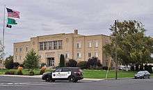 Adams County Courthouse (erected 1941) in 2014 | |
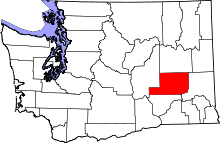 Location in the U.S. state of Washington | |
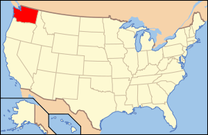 Washington's location in the U.S. | |
| Founded | 28 November, 1883 |
| Named for | John Adams |
| Seat | Ritzville |
| Largest city | Othello |
| Area | |
| • Total | 1,930 sq mi (4,999 km2) |
| • Land | 1,925 sq mi (4,986 km2) |
| • Water | 4.9 sq mi (13 km2), 0.3% |
| Population (est.) | |
| • (2017) | 19,506 |
| • Density | 10/sq mi (4/km2) |
| Congressional district | 4th |
| Time zone | Pacific: UTC−8/−7 |
| Website |
www |
Adams County is a county in the U.S. state of Washington. As of the 2010 census, the population was 18,728.[1] The county seat is at Ritzville, and its largest city is Othello. The county was formed out of Whitman County in November 1883[2] and is named for the second President of the United States, John Adams.
Adams County comprises the Othello, WA Micropolitan Statistical Area, which is also part of the Moses Lake-Othello, WA Combined Statistical Area.
History
The Governor of Washington Territory approved the proposed Adams County Articles of Incorporation on 28 November 1883. At that time Adams County and Franklin County were formed out of territory from Whitman County. The first County meeting (19 December 1883) established Ritzville as the county seat. By 1885 the county offices were established, in a wood-frame house purchased for the purpose in Ritzville.
The 1890 census showed that Adams County boasted 2,098 residents. The growing population justified a purpose-built courthouse, so construction began on 23 February 1892 for a two-story brick building with a tower and a basement.
Wheat farming was a main focus of early residents. In 1909 Adams County proclaimed itself "bread basket of the world," with Ritzville reportedly being the world's largest inland wheat exporter.
1905 - "A number of officials also appeared before the board [of county commissioners] and asked that an addition be built to the court house for the accommodation of the auditor and treasurer who require more room on account of the increase in business." The architectural firm of Preusse and Zittel of Spokane began drawing plans for the proposed addition in March 1905. Adams County Commissioners (Joseph M. Batten, Henry J. Allert and Fred Kembel) approved the new addition in May 1905.
In 1905 the County courthouse was expanded. Work was completed in October 1905.
Wheat producers in Adams County used dryland farming in order to overcome the relative aridity of the county's climate. They let the wheatfields lie fallow in alternate years, holding sufficient moisture to raise profitable crops.
The county's population decreased significantly during the first half of the twentieth century, dropping by nearly five thousand from 1910 to 1940.
In 1940 the courthouse was replaced by a three-story building, with a two-story jail at the rear. Construction was completed in December 1940.
In 1943 the Federal government approved the Columbia Basin Project. It began impacting Adams County in 1946, when construction of the East Low Canal and the Potholes East Canal began. This work, and the ensuing increased agricultural production from irrigated crops, led to continual population increases. The population had increased by 12,500 from 1940 to 2010.[3]
Geography
According to the U.S. Census Bureau, the county has a total area of 1,930 square miles (5,000 km2), of which 1,925 square miles (4,990 km2) is land and 4.9 square miles (13 km2) (0.3%) is water.[4]
Major highways
Adjacent counties
- Lincoln County - north
- Whitman County - east
- Franklin County - south
- Grant County - west
National protected areas
Demographics
| Historical population | |||
|---|---|---|---|
| Census | Pop. | %± | |
| 1890 | 2,098 | — | |
| 1900 | 4,840 | 130.7% | |
| 1910 | 10,920 | 125.6% | |
| 1920 | 9,623 | −11.9% | |
| 1930 | 7,719 | −19.8% | |
| 1940 | 6,209 | −19.6% | |
| 1950 | 6,584 | 6.0% | |
| 1960 | 9,929 | 50.8% | |
| 1970 | 12,014 | 21.0% | |
| 1980 | 13,267 | 10.4% | |
| 1990 | 13,603 | 2.5% | |
| 2000 | 16,428 | 20.8% | |
| 2010 | 18,728 | 14.0% | |
| Est. 2017 | 19,506 | [5] | 4.2% |
| U.S. Decennial Census[6] 1790–1960[7] 1900–1990[8] 1990–2000[9] 2010–2016[1] | |||
Adams County and Franklin County have the highest per capita percentage of Latino residents in the state.[10]
2000 census
As of the census[11] of 2000, there were 16,428 people, 5,229 households, and 4,094 families residing in the county. The population density was 8 people per square mile (3/km²). There were 5,773 housing units at an average density of 3 per square mile (1/km²). The racial makeup of the county was 64.96% White, 0.28% Black or African American, 0.68% Native American, 0.60% Asian, 0.04% Pacific Islander, 30.69% from other races, and 2.75% from two or more races. 16.3% were of German, 6.2% identified as U.S. or American and 5.6% English ancestry. 57.0% spoke English, 41.7% Spanish and 1.2% German as their first language.
There were 5,229 households out of which 44.00% had children under the age of 18 living with them, 63.50% were married couples living together, 10.10% had a female householder with no husband present, and 21.70% were non-families. 18.70% of all households were made up of individuals and 7.70% had someone living alone who was 65 years of age or older. The average household size was 3.09 and the average family size was 3.52.
In the county, the population was spread out with 34.20% under the age of 18, 9.80% from 18 to 24, 26.30% from 25 to 44, 19.40% from 45 to 64, and 10.40% who were 65 years of age or older. The median age was 30 years. For every 100 females there were 104.50 males. For every 100 females age 18 and over, there were 102.10 males.
The median income for a household in the county was $33,888, and the median income for a family was $37,075. Males had a median income of $28,740 versus $21,597 for females. The per capita income for the county was $13,534. About 13.60% of families and 18.20% of the population were below the poverty line, including 24.00% of those under age 18 and 8.90% of those age 65 or over.
2010 census
As of the 2010 United States Census, there were 18,728 people, 5,720 households, and 4,410 families residing in the county.[12] The population density was 9.7 inhabitants per square mile (3.7/km2). There were 6,242 housing units at an average density of 3.2 per square mile (1.2/km2).[13] The racial makeup of the county was 62.5% white, 1.9% American Indian, 0.7% Asian, 0.6% black or African American, 31.5% from other races, and 2.8% from two or more races. Those of Hispanic or Latino origin made up 59.3% of the population.[12] In terms of ancestry, 16.4% were German, 6.8% were Irish, 5.6% were English, and 2.2% were American.[14]
Of the 5,720 households, 47.9% had children under the age of 18 living with them, 58.7% were married couples living together, 11.8% had a female householder with no husband present, 22.9% were non-families, and 18.8% of all households were made up of individuals. The average household size was 3.25 and the average family size was 3.71. The median age was 29.0 years.[12]
The median income for a household in the county was $40,829 and the median income for a family was $43,551. Males had a median income of $35,695 versus $25,160 for females. The per capita income for the county was $16,689. About 19.0% of families and 25.1% of the population were below the poverty line, including 36.6% of those under age 18 and 12.6% of those age 65 or over.[15]
Communities
Cities
Towns
Unincorporated communities
Ghost towns
Politics
Adams County is a historically Republican county. The last Democrat to win the county was Franklin D. Roosevelt in 1936.[18] It was one of only three counties in the state to be won by Barry Goldwater in 1964. Along with neighboring Lincoln County it is the only county in Washington that has never been won by a Democratic candidate in the past thirteen presidential elections.[19] The Republican candidate has won by more than 13% in every Presidential election since 1992 and George W. Bush won the county by over 40% both times he ran.[20]
In state elections the results are similarly Republican. In the last thirteen elections no Democratic candidate for governor has carried Adams County.[21] The last Democratic candidate for US Senate to win the county was Henry M. Jackson in 1982.[22]
In the 2008 elections John McCain received 66.32% of the county's vote. Meanwhile, Republican nominee for governor Dino Rossi received 69.83% of the county's vote. They also gave Republican representative Cathy McMorris Rodgers 82.45% of their vote. In other results Republican Sam Reed received 74.6% of the county's vote in his run for re-election as Washington Secretary of State; Republican Allan Martin received 67.25% of the vote for state treasurer; and Republican Rob McKenna received 76.28% in his re-election run for Attorney general. All county positions, where party are mentioned, also went to the Republican.[23]
| Year | Republican | Democratic | Third parties |
|---|---|---|---|
| 2016 | 64.5% 3,083 | 27.2% 1,299 | 8.4% 400 |
| 2012 | 65.8% 3,171 | 31.9% 1,540 | 2.3% 111 |
| 2008 | 66.3% 3,222 | 32.0% 1,552 | 1.7% 84 |
| 2004 | 73.2% 3,751 | 25.7% 1,315 | 1.2% 61 |
| 2000 | 69.2% 3,440 | 28.3% 1,406 | 2.6% 128 |
| 1996 | 51.1% 2,356 | 37.7% 1,740 | 11.2% 518 |
| 1992 | 45.5% 2,087 | 31.6% 1,449 | 22.9% 1,049 |
| 1988 | 60.9% 2,612 | 37.6% 1,612 | 1.5% 64 |
| 1984 | 71.7% 3,449 | 27.3% 1,311 | 1.0% 49 |
| 1980 | 68.0% 3,248 | 25.6% 1,223 | 6.4% 305 |
| 1976 | 58.6% 2,795 | 37.5% 1,790 | 3.9% 188 |
| 1972 | 68.2% 3,083 | 24.6% 1,110 | 7.2% 326 |
| 1968 | 62.1% 2,572 | 30.7% 1,270 | 7.2% 299 |
| 1964 | 52.5% 2,241 | 47.4% 2,027 | 0.1% 5 |
| 1960 | 58.8% 2,479 | 41.1% 1,732 | 0.1% 5 |
| 1956 | 57.5% 2,267 | 42.4% 1,673 | 0.1% 4 |
| 1952 | 66.3% 2,181 | 33.6% 1,104 | 0.2% 5 |
| 1948 | 52.0% 1,394 | 47.2% 1,267 | 0.8% 22 |
| 1944 | 60.8% 1,666 | 38.8% 1,062 | 0.4% 12 |
| 1940 | 51.7% 1,508 | 47.9% 1,397 | 0.5% 13 |
| 1936 | 24.7% 657 | 73.1% 1,944 | 2.3% 60 |
| 1932 | 35.7% 867 | 61.9% 1,504 | 2.4% 59 |
| 1928 | 64.1% 1,473 | 35.1% 807 | 0.8% 19 |
| 1924 | 37.5% 760 | 11.3% 228 | 51.2% 1,038 |
| 1920 | 67.2% 1,525 | 22.7% 515 | 10.2% 231 |
| 1916 | 46.3% 1,237 | 48.4% 1,294 | 5.3% 142 |
| 1912 | 17.0% 398 | 40.6% 949 | 42.4% 991[lower-alpha 1] |
| 1908 | 55.8% 1,033 | 38.6% 714 | 5.6% 104 |
| 1904 | 64.4% 1,138 | 31.0% 548 | 4.5% 80 |
| 1900 | 45.0% 461 | 51.0% 523 | 4.0% 41 |
| 1896 | 38.8% 243 | 59.4% 372 | 1.8% 11 |
| 1892 | 42.8% 244 | 24.4% 139 | 32.8% 187 |
Courthouses
From Ritzville's designation as county seat in 1884 until 1892, courts were briefly held in rented space before the county purchased a building from N.H. Greene in 1885. In 1891 the commission bonded $20,000 in order to erect a permanent court house. The building was built by the Spokane firm of Burnham and Clapp and completed by August 20, 1891, when it was accepted by the county. It was a two-story brick building with a four-story tower and a stone basement. A two-story addition was added to the front in 1905 with a new four-story tower, giving the courthouse a whole new appearance. This building was replaced by the current art-deco courthouse in 1940.
See also
Notes
- ↑ The leading "other" candidate, Progressive Theodore Roosevelt, received 788 votes, while Socialist candidate Eugene Debs received 155 votes, Prohibition candidate Eugene Chafin received 42 votes, and Socialist Labor candidate Arthur Reimer received 6 votes.
References
- 1 2 "State & County QuickFacts". United States Census Bureau. Archived from the original on 6 July 2011. Retrieved 7 January 2014.
- ↑ "Milestones for Washington State History — Part 2: 1851 to 1900". HistoryLink.org. 6 March 2003.
- ↑ About Adams County
- ↑ "2010 Census Gazetteer Files". United States Census Bureau. 22 August 2012. Retrieved 4 July 2015.
- ↑ "Population and Housing Unit Estimates". Retrieved 4 April 2018.
- ↑ "U.S. Decennial Census". United States Census Bureau. Archived from the original on 12 May 2015. Retrieved 7 January 2014.
- ↑ "Historical Census Browser". University of Virginia Library. Retrieved 7 January 2014.
- ↑ "Population of Counties by Decennial Census: 1900 to 1990". United States Census Bureau. Retrieved 7 January 2014.
- ↑ "Census 2000 PHC-T-4. Ranking Tables for Counties: 1990 and 2000" (PDF). United States Census Bureau. Retrieved 7 January 2014.
- ↑ reddit Map
- ↑ "American FactFinder". United States Census Bureau. Archived from the original on 11 September 2013. Retrieved 14 May 2011.
- 1 2 3 "Profile of General Population and Housing Characteristics: 2010 Demographic Profile Data". United States Census Bureau. Retrieved 1 March 2016.
- ↑ "Population, Housing Units, Area, and Density: 2010 - County". United States Census Bureau. Retrieved 1 March 2016.
- ↑ "Selected Social Characteristics in the United States – 2006-2010 American Community Survey 5-Year Estimates". United States Census Bureau. Retrieved 1 March 2016.
- ↑ "Selected Economic Characteristics – 2006-2010 American Community Survey 5-Year Estimates". United States Census Bureau. Retrieved 1 March 2016.
- ↑ "Griffith (Adams County, Washington): Searching for Information". roadsidethoughts.com. Retrieved 5 April 2018.
- ↑ "The USGenWeb Archives Project - Adams County, Washington: Griffith Cemetery Tombstone Photos". www.usgwarchives.net. Retrieved 5 April 2018.
- ↑ "Presidential election of 1936 - Map by counties". geoelections.free.fr. Retrieved 5 April 2018.
- ↑ David Leip’s Presidential Atlas (Maps for Washington by election)
- ↑ The New York Times Electoral Map (Zoom in on Washington state)
- ↑ David Leip's US Election Atlas (Washington state maps)
- ↑ David Leip's US Election Atlas (Washington state maps)
- ↑ Election results for Adams County at Washington governmental site Archived 8 December 2008 at the Wayback Machine.
- ↑ Leip, David. "Dave Leip's Atlas of U.S. Presidential Elections". uselectionatlas.org. Retrieved 5 April 2018.
Further reading
- An illustrated history of the Big Bend country : embracing Lincoln, Douglas, Adams, and Franklin counties, state of Washington. Western Historical Pub. Co. 1904. Available online through the Washington State Library's Classics in Washington History collection
Amber Waves and Undertow -Peril, Hope, Sweat, and Downright Nonchalance in Dry Wheat Country- a book written by Steve Turner and published by the University of Oklahoma Press 2009 - ISBN 978-0-8061-4005-6
External links
- Adams County, Washington
- Image of 1892 Adams County Courthouse at the Washington State Digital Archives.
- Image of 1905 Adams County Courthouse addition at the Washington State Digital Archives.
- Image of 1941 Adams County Courthouse at the Washington State Digital Archives.
- Top Hat Motel in Ritzville, WA
Places adjacent to Adams County, Washington | ||||||||||
|---|---|---|---|---|---|---|---|---|---|---|
| ||||||||||
Municipalities and communities of Adams County, Washington, United States | ||
|---|---|---|
| Cities | | |
| Towns | ||
| Unincorporated community | ||
| Ghost towns | ||
