Whitney, Nevada
| Whitney, Nevada | |
|---|---|
| Unincorporated town | |
 | |
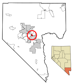 Location of Whitney in Clark County, Nevada | |
| Coordinates: 36°5′47″N 115°2′39″W / 36.09639°N 115.04417°WCoordinates: 36°5′47″N 115°2′39″W / 36.09639°N 115.04417°W | |
| Country | United States |
| State | Nevada |
| County | Clark |
| Area | |
| • Total | 6.8 sq mi (17.5 km2) |
| • Land | 6.8 sq mi (17.5 km2) |
| Elevation | 1,942 ft (592 m) |
| Population (2010) | |
| • Total | 38,585 |
| • Density | 5,700/sq mi (2,200/km2) |
| Time zone | UTC−8 (PST) |
| • Summer (DST) | UTC−7 (PDT) |
| FIPS code | 32-83800 |
| GNIS feature ID | 1877236 |
| Website | Whitney Town Advisory Board |
Whitney (formerly East Las Vegas) is an unincorporated town[1] and census-designated place in Clark County, Nevada, United States. The population was 38,585 at the 2010 census.[2]
Background
Stowell E. Whitney purchased a ranch in the area in the 1910s.[3][4] The town of Whitney was established in 1931, when Whitney subdivided his ranch.[3] A Whitney post office was opened the following year.[3][5] The town was renamed as East Las Vegas in 1958, in response to a petition signed by almost all the residents.[6] The name was changed back to Whitney in 1993.[7]
Prior to the 1970s, Whitney was one of a few small communities between Las Vegas and Henderson along Boulder Highway (which was US 93, US 95 and US 466 at the time). Whitney Elementary School was a converted barracks. It housed grades from first to seventh until the 1960s, then the seventh graders were moved to Henderson Junior High. In the early years, the town's post office was operated by John and Nellie Bunch, owners of much of the Whitney property and surrounding areas. The town consisted of three streets running east and west: Whitney Avenue, Keenan Avenue, and Missouri Avenue. Cross streets running north and south were 1st Street, 2nd Street, and 3rd Street. Older students attended Basic High School in Henderson.
In the early 1990s, the outward growth of development in Las Vegas and Henderson, as well as the construction of the Interstate 515 bypass of Whitney, had a negative impact on businesses in the area. It wasn't until the early 2000s that business began to recover. The area has seen several new housing developments on vacant land.
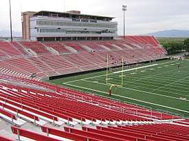
It is home to Sam Boyd Stadium (formerly the Silver Bowl), the home of the UNLV Rebels college football team.
Geography
According to the United States Census Bureau, the census-designated place (CDP) of Whitney (which may not coincide exactly with the town boundaries) has a total area of 6.8 square miles (17.5 km2), all of it land.[8]
Government
As an unincorporated town, Whitney is directly managed by the Clark County Commission. Federally, it is split between the 1st and 3rd Congressional Districts. In state politics, it is part of State Senate District 7, represented by Democrat David Parks and Assembly District 18, which is represented by Democrat Richard Carrillo.[9]
Demographics
| Historical population | |||
|---|---|---|---|
| Census | Pop. | %± | |
| 1970 | 6,501 | — | |
| 1980 | 6,449 | −0.8% | |
| 1990 | 11,087 | 71.9% | |
| 2000 | 18,273 | 64.8% | |
| 2010 | 38,585 | 111.2% | |
| source:[10][11] | |||
As of the census[12] of 2000, there were 18,273 people, 7,090 households, and 4,502 families residing in the CDP. The population density was 2,438.9 people per square mile (942.0/km²). There were 7,849 housing units at an average density of 1,047.6 per square mile (404.6/km²). The racial makeup of the CDP was 72.24% White, 6.82% African American, 1.11% Native American, 3.81% Asian, 0.45% Pacific Islander, 11.04% from other races, and 4.53% from two or more races. Hispanic or Latino of any race were 25.29% of the population.
There were 7,090 households out of which 28.7% had children under the age of 18 living with them, 42.8% were married couples living together, 14.2% had a female householder with no husband present, and 36.5% were non-families. 27.8% of all households were made up of individuals and 6.9% had someone living alone who was 65 years of age or older. The average household size was 2.57 and the average family size was 3.14.
In the CDP, the population was spread out with 25.1% under the age of 18, 9.2% from 18 to 24, 31.3% from 25 to 44, 23.4% from 45 to 64, and 11.0% who were 65 years of age or older. The median age was 35 years. For every 100 females, there were 104.8 males. For every 100 females age 18 and over, there were 103.8 males.
The median income for a household in the CDP was $36,536, and the median income for a family was $41,504. Males had a median income of $30,833 versus $23,988 for females. The per capita income for the CDP was $16,969. About 8.2% of families and 9.7% of the population were below the poverty line, including 13.1% of those under age 18 and 5.6% of those age 65 or over.
References
- ↑
- ↑ "Profile of General Population and Housing Characteristics: 2010 Demographic Profile Data (DP-1): Whitney CDP, Nevada". U.S. Census Bureau, American Factfinder. Retrieved March 13, 2012.
- 1 2 3 Emmily N. Bristol (January 20, 2001). "Back at the ranch: Whitney blazed a trail". Henderson View – via NewsBank.
- ↑ US-95, West Leg Construction from Rancho Drive West to Rainbow Blvd and North to US-95, Clark County: Environmental Impact Statement (Report). Federal Highway Administration. 1976. p. 1999.
- ↑ Helen S. Carlson (1974). Nevada Place Names: A Geographical Dictionary. University of Nevada Press.
- ↑ "Town renamed East Las Vegas". Reno Gazette-Journal. October 9, 1958 – via Newspapers.com.
- ↑ 2011 Whitney Land Use Plan (PDF) (Report). Clark County Planning Commission. May 3, 2011. p. 4. Retrieved 2017-10-28.
- ↑ "Geographic Identifiers: 2010 Demographic Profile Data (DP-1): Whitney CDP, Nevada". U.S. Census Bureau, American Factfinder. Retrieved March 13, 2012.
- ↑ "Who's My Legislator / What's My District". mapserve1.leg.state.nv.us. Retrieved 2016-08-11.
- ↑ "CENSUS OF POPULATION AND HOUSING (1790-2000)". U.S. Census Bureau. Retrieved 2010-07-17.
- ↑ Census area enumerated as East Las Vegas from 1970 to 1990.
- ↑ "American FactFinder". United States Census Bureau. Retrieved 2008-01-31.
Municipalities and communities of Clark County, Nevada, United States | ||
|---|---|---|
| Cities |  | |
| CDPs | ||
| Unincorporated communities | ||
| Township | ||
| Ghost towns | ||
| Indian reservations | ||
| Footnotes | ‡This populated place also has portions in an adjacent county or counties | |
Carson City (capital) | ||
| Topics |
|  |
| Society | ||
| Regions | ||
| Metro areas | ||
| Counties | ||
| Cities and communities |
| |
| Former counties | ||