Esmeralda County, Nevada
| Esmeralda County, Nevada | ||
|---|---|---|
| County | ||
| Esmeralda County | ||
 Esmeralda County Courthouse in Goldfield | ||
| ||
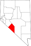 Location in the U.S. state of Nevada | ||
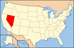 Nevada's location in the U.S. | ||
| Founded | 1861 | |
| Seat | Goldfield | |
| Largest community | Goldfield | |
| Area | ||
| • Total | 3,589 sq mi (9,295 km2) | |
| • Land | 3,582 sq mi (9,277 km2) | |
| • Water | 7.2 sq mi (19 km2), 0.2% | |
| Population | ||
| • (2010) | 783 | |
| • Density | 0.2/sq mi (0.08/km2) | |
| Congressional district | 4th | |
| Time zone | Pacific: UTC−8/−7 | |
| Website |
accessesmeralda | |

Esmeralda County is a county in the west of U.S. state of Nevada. As of the 2010 census, the population was 783,[1] making it the least populous county in Nevada. Esmeralda County does not have any incorporated communities. Its county seat is the town of Goldfield.[2]
Its 2000 census population density of 0.2706 inhabitants per square mile (0.1045/km2) was the second-lowest of any county in the contiguous United States (above Loving County, Texas). Its school district does not have a high school, so students in grades 9-12 go to school in Tonopah, in the Nye County School District. Esmeralda is the only Nevada county in the Los Angeles TV market (or any California market) as defined by A.C. Nielsen.[3]
History
Esmeralda County is one of the original counties in Nevada, established in 1861. When it was organized, it comprised the part of the Nevada Territory south of the 39th parallel and east of Mason Valley.[4] Esmeralda is the Spanish and Portuguese word for "emerald". An early California miner from San Jose Ca, James Manning Cory, named the Esmeralda Mining District after Esmeralda the Gypsy dancer from The Hunchback of Notre Dame.[5]
Just after the organization of Esmeralda County, the vast majority of the land area had yet to be discovered. John C. Frémont was one of the few people who had explored parts of the county. He had crossed Big Smoky Valley in 1845. Also, Aurora and its northern corridor had been discovered. In 1862 and 1863, the area along the Reese River was discovered during the Reese River excitement. The event resulted in the establishment of three mining districts in the Toiyabe Range, namely Marysville, Twin River, and Washington, and the establishment of a number of settlements and ranches in Esmeralda County. Explorers pursued south and explored the Shoshone Mountains. The mining district Union was organized after silver was found in 1863 and the settlement of Ione was founded there.[4]
The total area of Esmeralda County more than halved as Nye County was organized on February 16, 1864. That county was entirely created out of land that used to be part of Esmeralda County.[4] Esmeralda has had three county seats: Aurora until 1883, Hawthorne from 1883 to 1907 and finally Goldfield. At one point, due to the disputed border with California, Aurora was simultaneously the county seat of both Mono County, California and Esmeralda County, Nevada. Samuel Clemens (Mark Twain) wrote about his time as a miner in the Esmeralda District in his book Roughing It.
Esmeralda grew from a gold mining boom in the first years of the 20th century. The mines were largely tapped out by the end of the 1910s and the economy and population declined afterwards.
Geography
According to the U.S. Census Bureau, the county has a total area of 3,589 square miles (9,300 km2), of which 3,582 square miles (9,280 km2) is land and 7.2 square miles (19 km2) (0.2%) is water.[6] It is the fourth-smallest county in Nevada by area. A very small part of Death Valley National Park lies in its southeast corner.
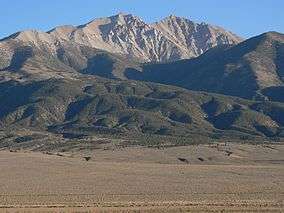
The county is dominated by the Silver Peak and Monte Cristo mountain ranges. Mountains in the county include:
- Boundary Peak, 13,147 feet (4,007 m), the highest natural point in Nevada
- Piper Peak, 9450 feet (2,880 m), the most prominent peak in Esmeralda County
- Magruder Mountain 9044 feet (2,756 m)
- Montezuma Peak, 8373 feet (2,552 m)
- Emigrant Peak, 6790 feet (2,069 m)
Highways
Adjacent counties
- Mineral County - northwest
- Nye County - east
- Inyo County, California - south
- Mono County, California - west
National protected areas
- Death Valley National Park (part)
- Inyo National Forest (part)
Demographics
| Historical population | |||
|---|---|---|---|
| Census | Pop. | %± | |
| 1870 | 1,553 | — | |
| 1880 | 3,220 | 107.3% | |
| 1890 | 2,148 | −33.3% | |
| 1900 | 1,972 | −8.2% | |
| 1910 | 9,369 | 375.1% | |
| 1920 | 2,410 | −74.3% | |
| 1930 | 1,077 | −55.3% | |
| 1940 | 1,554 | 44.3% | |
| 1950 | 614 | −60.5% | |
| 1960 | 619 | 0.8% | |
| 1970 | 629 | 1.6% | |
| 1980 | 777 | 23.5% | |
| 1990 | 1,344 | 73.0% | |
| 2000 | 971 | −27.8% | |
| 2010 | 783 | −19.4% | |
| Est. 2016 | 790 | [7] | 0.9% |
| U.S. Decennial Census[8] 1790-1960[9] 1900-1990[10] 1990-2000[11] 2010-2013[1] | |||
2000 census
As of the census[12] of 2000, there were 971 people, 455 households, and 259 families residing in the county. The population density was 0 people per square mile (0/km²). There were 833 housing units at an average density of 0 per square mile (0/km²). The racial makeup of the county was 81.98% White, 0.10% Black or African American, 5.15% Native American, 0.21% Pacific Islander, 7.62% from other races, and 4.94% from two or more races. 10.20% of the population were Hispanic or Latino of any race.
There were 455 households out of which 21.10% had children under the age of 18 living with them, 46.40% were married couples living together, 6.40% had a female householder with no husband present, and 42.90% were non-families. 36.00% of all households were made up of individuals and 13.20% had someone living alone who was 65 years of age or older. The average household size was 2.12 and the average family size was 2.79.
In the county, the population was spread out with 20.50% under the age of 18, 6.00% from 18 to 24, 23.40% from 25 to 44, 33.00% from 45 to 64, and 17.20% who were 65 years of age or older. The median age was 45 years. For every 100 females there were 123.70 males. For every 100 females age 18 and over, there were 118.70 males.
The median income for a household in the county was $33,203, and the median income for a family was $40,917. Males had a median income of $39,327 versus $25,469 for females. The per capita income for the county was $18,971. 15.30% of the population and 7.50% of families were below the poverty line. Out of the total people living in poverty, 9.70% are under the age of 18 and 11.40% are 65 or older.
2010 census
As of the 2010 United States Census, there were 783 people, 389 households, and 213 families residing in the county.[13] The population density was 0.2 inhabitants per square mile (0.077/km2). There were 850 housing units at an average density of 0.2 per square mile (0.077/km2).[14] The racial makeup of the county was 84.4% white, 4.2% American Indian, 0.4% Asian, 6.6% from other races, and 4.3% from two or more races. Those of Hispanic or Latino origin made up 15.3% of the population.[13] In terms of ancestry, 26.7% were German, 18.6% were English, 14.0% were American, 13.8% were Irish, and 8.7% were Swedish.[15]
Of the 389 households, 18.3% had children under the age of 18 living with them, 43.4% were married couples living together, 5.9% had a female householder with no husband present, 45.2% were non-families, and 40.6% of all households were made up of individuals. The average household size was 2.01 and the average family size was 2.67. The median age was 52.9 years.[13]
The median income for a household in the county was $39,712 and the median income for a family was $57,292. Males had a median income of $41,023 versus $27,019 for females. The per capita income for the county was $34,571. About 6.7% of families and 11.2% of the population were below the poverty line, including 9.8% of those under age 18 and 9.4% of those age 65 or over.[16]
Law and government
The county seat of Esmeralda County is Goldfield. It was moved to Goldfield on May 1, 1907. The courthouse was opened on May 1, 1908 and has been in continuous use since then. Currently, the Offices of the Assessor, Auditor/Recorder, District Attorney, Sheriff/Jail, Justice of the Peace, Treasurer, District Court, and Commissioner are located in the building.
Politics
| Year | Republican | Democratic | Third parties |
|---|---|---|---|
| 2016 | 77.8% 329 | 15.4% 65 | 6.9% 29 |
| 2012 | 72.9% 317 | 21.2% 92 | 6.0% 26 |
| 2008 | 69.0% 303 | 23.7% 104 | 7.3% 32 |
| 2004 | 76.3% 367 | 20.6% 99 | 3.1% 15 |
| 2000 | 67.8% 333 | 23.6% 116 | 8.6% 42 |
| 1996 | 50.7% 277 | 25.6% 140 | 23.6% 129 |
| 1992 | 37.8% 221 | 20.2% 118 | 42.0% 245[lower-alpha 1] |
| 1988 | 68.8% 380 | 25.9% 143 | 5.3% 29 |
| 1984 | 70.0% 453 | 24.4% 158 | 5.6% 36 |
| 1980 | 66.3% 311 | 23.5% 110 | 10.2% 48 |
| 1976 | 43.5% 181 | 51.4% 214 | 5.1% 21 |
| 1972 | 68.3% 273 | 31.8% 127 | |
| 1968 | 39.1% 138 | 33.4% 118 | 27.5% 97 |
| 1964 | 41.2% 131 | 58.8% 187 | |
| 1960 | 42.1% 156 | 58.0% 215 | |
| 1956 | 56.9% 164 | 43.1% 124 | |
| 1952 | 55.6% 174 | 44.4% 139 | |
| 1948 | 44.9% 164 | 50.1% 183 | 4.9% 18 |
| 1944 | 40.2% 150 | 59.8% 223 | |
| 1940 | 31.4% 292 | 68.6% 639 | |
| 1936 | 21.6% 156 | 78.4% 566 | |
| 1932 | 25.7% 147 | 74.4% 426 | |
| 1928 | 47.2% 305 | 52.8% 341 | |
| 1924 | 33.2% 241 | 20.7% 150 | 46.1% 335 |
| 1920 | 49.6% 466 | 36.9% 347 | 13.5% 127 |
| 1916 | 31.1% 709 | 49.8% 1,135 | 19.2% 437 |
| 1912 | 13.8% 252 | 39.1% 713 | 47.1% 860[lower-alpha 2] |
| 1908 | 38.2% 2,208 | 48.2% 2,787 | 13.6% 789 |
| 1904 | 42.2% 490 | 32.7% 380 | 25.1% 291 |
Education
The Esmeralda County School District has three elementary schools that currently serve approximately 90 students.
Communities
Unincorporated communities
Each of these communities is a census-designated place:
- Dyer
- Goldfield (county seat)
- Silver Peak
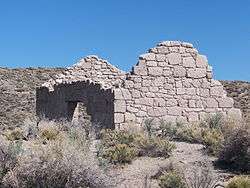
Ghost towns
See also
Notes
- ↑ The leading “other” candidate, Independent Ross Perot, received 220 votes, while Populist candidate James Gritz received 18 votes, Libertarian candidate Andre Marrou received 5 votes, New Alliance candidate Lenora Fulani received one vote, and the option None of these candidates received one vote.
- ↑ The leading "other" candidate, Progressive Theodore Roosevelt, received 481 votes, while Socialist candidate Eugene Debs received 379 votes.
References
- 1 2 "State & County QuickFacts". United States Census Bureau. Archived from the original on July 10, 2011. Retrieved September 23, 2013.
- ↑ "County Explorer". National Association of Counties. Retrieved 2011-06-07.
- ↑ Nielsen DMA-Designated Market Area Regions 2012-2013, The Nielsen Company, 2012.
- 1 2 3 Thompson; West (1881). History of Nevada. Oakland, California. pp. 512 and 513. Retrieved 7 February 2016.
- ↑ Paul F. Starrs, "Esmeralda County, Nevada: Empty Land? Poor Land? Fair Land? Masters thesis, Geography, University of California, Berkeley, 1984
- ↑ "2010 Census Gazetteer Files". United States Census Bureau. August 22, 2012. Retrieved December 20, 2014.
- ↑ "Population and Housing Unit Estimates". Retrieved June 9, 2017.
- ↑ "U.S. Decennial Census". United States Census Bureau. Archived from the original on May 12, 2015. Retrieved December 20, 2014.
- ↑ "Historical Census Browser". University of Virginia Library. Retrieved December 20, 2014.
- ↑ "Population of Counties by Decennial Census: 1900 to 1990". United States Census Bureau. Retrieved December 20, 2014.
- ↑ "Census 2000 PHC-T-4. Ranking Tables for Counties: 1990 and 2000" (PDF). United States Census Bureau. Retrieved December 20, 2014.
- ↑ "American FactFinder". United States Census Bureau. Archived from the original on 2013-09-11. Retrieved 2008-01-31.
- 1 2 3 "DP-1 Profile of General Population and Housing Characteristics: 2010 Demographic Profile Data". United States Census Bureau. Retrieved 2016-01-21.
- ↑ "Population, Housing Units, Area, and Density: 2010 - County". United States Census Bureau. Retrieved 2016-01-21.
- ↑ "DP02 SELECTED SOCIAL CHARACTERISTICS IN THE UNITED STATES – 2006-2010 American Community Survey 5-Year Estimates". United States Census Bureau. Retrieved 2016-01-21.
- ↑ "DP03 SELECTED ECONOMIC CHARACTERISTICS – 2006-2010 American Community Survey 5-Year Estimates". United States Census Bureau. Retrieved 2016-01-21.
- ↑ Leip, David. "Dave Leip's Atlas of U.S. Presidential Elections". uselectionatlas.org. Retrieved 2018-04-12.
External links
| Wikimedia Commons has media related to Esmeralda County, Nevada. |
Places adjacent to Esmeralda County, Nevada | ||||||||||
|---|---|---|---|---|---|---|---|---|---|---|
| ||||||||||
Municipalities and communities of Esmeralda County, Nevada, United States | ||
|---|---|---|
| CDPs | | |
| Ghost towns | ||