Prince of Wales–Hyder Census Area, Alaska
| Prince of Wales-Hyder Census Area, Alaska | |
|---|---|
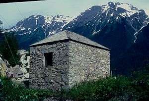 Hyder, Storehouse No. 4, built by David du Bose Gaillard. | |
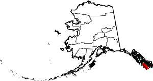 Location in the U.S. state of Alaska | |
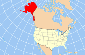 Alaska's location in the U.S. | |
| Established | 2008[1] |
| Largest city | Craig |
| Area | |
| • Total | 7,683 sq mi (19,899 km2) |
| • Land | 3,923 sq mi (10,161 km2) |
| • Water | 3,760 sq mi (9,738 km2), 48.9% |
| Population (est.) | |
| • (2017) | 6,443 |
| • Density | 1.42/sq mi (0.55/km2) |
| Congressional district | At-large |
| Time zone | Alaska: UTC−9/−8 |
Prince of Wales–Hyder Census Area is a census area located in the U.S. state of Alaska. As of the 2010 census, the population was 5,559.[2] It is part of the unorganized borough and therefore has no borough seat. Its largest communities are Craig and Metlakatla. It was formerly part of the Census Bureau's Prince of Wales–Outer Ketchikan Census Area, but the name was changed in 2008 after most of the Outer Ketchikan (except the parts near the community of Hyder, and Annette Island) was lost to annexation by the Ketchikan Gateway Borough.
Geography
According to the U.S. Census Bureau, the census area has a total area of 7,683 square miles (19,900 km2), of which 3,923 square miles (10,160 km2) is land and 3,760 square miles (9,700 km2) (48.9%) is water.[3] The present-day Prince of Wales–Hyder Census Area includes the Hyder area as an exclave, and Annette Island, which is mostly surrounded by territory of Ketchikan Gateway Borough.[4] Before the transfer of territory, Ketchikan Gateway Borough was enclaved within (surrounded by) the census area.
Adjacent boroughs and census areas
- Petersburg Borough – north
- City and Borough of Wrangell, Alaska – northeast
- Ketchikan Gateway Borough – between Prince of Wales and Hyder
- Kitimat-Stikine Regional District, British Columbia – east
- Skeena-Queen Charlotte Regional District, British Columbia – south (water boundary only, across Dixon Entrance to Hecate Strait)
National protected areas
- Alaska Maritime National Wildlife Refuge (part of Gulf of Alaska unit)
- Tongass National Forest (part)
- Karta River Wilderness
- Maurille Islands Wilderness
- South Prince of Wales Wilderness
- Warren Island Wilderness
Demographics
| Historical population | |||
|---|---|---|---|
| Census | Pop. | %± | |
| 1960 | 1,772 | — | |
| 1970 | 2,106 | 18.8% | |
| 1980 | 3,822 | 81.5% | |
| 1990 | 6,278 | 64.3% | |
| 2000 | 6,146 | −2.1% | |
| 2010 | 5,559 | −9.6% | |
| Est. 2017 | 6,443 | [5] | 15.9% |
| U.S. Decennial Census[6] 1790–1960[7] 1900–1990[8] 1990–2000[9] 2010–2017[2] | |||
As of the census[10] of 2000, there were 6,146 people, 2,262 households, and 1,535 families residing in the then-census area. The population density was 1 people per square mile (0/km²). There were 3,055 housing units at an average density of 0 persons/km² (0 persons/sq mi). The racial makeup of the census area was 53.12% White, 0.15% African American, 38.68% Native American, 0.36% Asian, 0.05% Pacific Islander, 0.50% from other races, and 7.14% from two or more races. Hispanic or Latino of any race were 1.74% of any race.
There were 2,262 households out of which 37.60% had children under the age of 18 living with them, 50.80% were married couples living together, 10.00% have a woman whose husband does not live with her, and 32.10% were non-families. 26.00% of all households were made up of individuals and 5.00% had someone living alone who was 65 years of age or older. The average household size was 2.68 and the average family size was 3.25.
In the census area the population was spread out with 31.00% under the age of 18, 7.50% from 18 to 24, 30.10% from 25 to 44, 25.80% from 45 to 64, and 5.70% who were 65 years of age or older. The median age was 35 years. For every 100 females there were 119.80 males. For every 100 females age 18 and over, there were 125.60 males.
Communities
Cities
Census-designated places
Other
See also
References
- ↑ The census area acquired its current name in 2008, after the Outer Ketchikan was annexed by the Ketchikan Gateway Borough.
- 1 2 "State & County QuickFacts". United States Census Bureau. Retrieved May 18, 2014.
- ↑ "US Gazetteer files: 2010, 2000, and 1990". United States Census Bureau. 2011-02-12. Retrieved 2011-04-23.
- ↑ Map: Prince of Wales–Hyder Census Area Archived 2009-08-11 at the Wayback Machine. Alaska Department of Labor
- ↑ "Population and Housing Unit Estimates". Retrieved June 9, 2017.
- ↑ "U.S. Decennial Census". United States Census Bureau. Retrieved May 18, 2014.
- ↑ "Historical Census Browser". University of Virginia Library. Retrieved May 18, 2014.
- ↑ "Population of Counties by Decennial Census: 1900 to 1990". United States Census Bureau. Retrieved May 18, 2014.
- ↑ "Census 2000 PHC-T-4. Ranking Tables for Counties: 1990 and 2000" (PDF). United States Census Bureau. Retrieved May 18, 2014.
- ↑ "American FactFinder". United States Census Bureau. Retrieved 2011-05-14.
External links
- Prince of Wales–Outer Ketchikan Census Area map, 2000 census: Alaska Department of Labor
- Prince of Wales–Hyder Census Area map, 2010 census: Alaska Department of Labor
- Prince of Wales–Hyder Census Area map, January 2014: Alaska Department of Labor
Places adjacent to Prince of Wales–Hyder Census Area, Alaska | ||||||||||
|---|---|---|---|---|---|---|---|---|---|---|
| ||||||||||
Municipalities and communities of Prince of Wales–Hyder Census Area, Alaska, United States | ||
|---|---|---|
| Cities | | |
| CDPs | ||
| Unincorporated community | ||
| Indian reservation | ||
Juneau (capital) | ||
| Topics |  | |
| Society | ||
| Regions | ||
| Largest cities pop. over 25,000 | ||
| Smaller cities pop. over 2,000 | ||
| Boroughs | ||
| Census Areas | ||