Panaca, Nevada
| Panaca, Nevada | |
|---|---|
| Unincorporated town | |
 Main Street in Panaca | |
 Panaca Location within the state of Nevada | |
| Coordinates: 37°47′28″N 114°23′20″W / 37.79111°N 114.38889°WCoordinates: 37°47′28″N 114°23′20″W / 37.79111°N 114.38889°W | |
| Country | United States |
| State | Nevada |
| County | Lincoln |
| Area | |
| • Total | 3.3 sq mi (8.5 km2) |
| • Land | 3.3 sq mi (8.5 km2) |
| • Water | 0 sq mi (0 km2) |
| Population (2010) | |
| • Total | 963 |
| • Density | 290/sq mi (110/km2) |
| Time zone | UTC−8 (Pacific (PST)) |
| • Summer (DST) | UTC−7 (PDT) |
| ZIP code | 89042 |
| Area code(s) | 775 |
| FIPS code | 32-54200 |
| GNIS feature ID | 0847542 |
| Reference no. | 39 |
Panaca is an unincorporated town[1] in eastern Lincoln County, Nevada, United States, on State Route 319, about 1 mile (1.6 kilometers) east of U.S. Route 93, near the border with Utah. Its elevation is 4,729 feet (1,441 meters) above sea level. As of the 2010 census, it had a population of 963.[2] It is one of only two cities in Nevada that prohibits gambling, the other being Boulder City.[3]
History


Panaca was southern Nevada's first permanent settlement, founded as a Mormon colony in 1864.[4] It was originally part of Washington County, Utah, but the congressional redrawing of boundaries in 1866 shifted Panaca into Nevada. It is the only community in Nevada to be "dry" (forbidding the sale of alcoholic beverages),[5] and the only community in Nevada, besides Boulder City, that prohibits gambling.[3]
Coke ovens here once produced charcoal for the smelters in nearby Bullionville (now a ghost town), but the town's economy is predominantly agricultural.
The name "Panaca" comes from the Southern Paiute word Pan-nuk-ker, which means "metal, money, wealth". William Hamblin, a Mormon missionary to the Paiutes, established the Panacker Ledge (Panaca Claim) silver mine there in 1864.[6]
Geography
According to the U.S. Census Bureau, the Panaca census-designated place has an area of 3.3 square miles (8.5 km2), all of it land.[2] Along Nevada State Route 319 it is 19 miles (31 km) east to the Utah state line and from there another 60 miles (97 km) east to Cedar City, Utah. West from Panaca it is 1.0 mile (1.6 km) to U.S. Route 93, at which point it is 11 miles (18 km) north to Pioche and 14 miles (23 km) south to Caliente.
Attractions
Panaca is near Cathedral Gorge State Park.
The following Nevada historical markers have been placed in Panaca:[7]
- Panaca (#39)
- Panaca Mercantile Store (#93)
- Panaca Spring (#160)
- Panaca Ward Chapel (#182)
Panaca celebrates Pioneer Day on the Saturday closest to July 24. Events include a 6 a.m. cannon firing, games and races, a parade, art displays, and a community dinner. This coincides with the Utah holiday commemorating the arrival of the Mormon pioneers in the Salt Lake Valley.[8][9]
See also

References
- ↑ "Lincoln County Code - Section 1-5-3: Panaca". Sterling Codifiers. Retrieved January 27, 2017.
- 1 2 "Geographic Identifiers: 2010 Demographic Profile Data (G001): Panaca CDP, Nevada". U.S. Census Bureau, American Factfinder. Retrieved January 25, 2013.
- 1 2 Jamie., Jensen, (2006-01-01). Road trip USA : cross-country adventures on America's two-lane highways. Avalon Travel. ISBN 9781566917667. OCLC 74323111.
- ↑ Federal Writers' Project (1941). Origin of Place Names: Nevada (PDF). W.P.A. p. 46.
- ↑ "NABCA list of Wet and Dry Counties" (PDF).
- ↑ "The town of Panaca". LincolnCountyNevada.com. Lincoln Communities Action Team. Archived from the original on 2014-07-17. Retrieved 2014-07-23.
- ↑ "Lincoln County, Nevada". Historical Markers. Nevada State Historic Preservation Office (SHPO). Retrieved 2014-07-23.
- ↑ Dave Maxwell (August 5, 2013). "Pioneer Days: Panaca celebrates heritage". Lincoln County Record. Retrieved 2014-07-23.
- ↑ Velotta, Richard N. (July 23, 2014). "Panaca shares sesquicentennial with Nevada". Las Vegas Review-Journal. Retrieved 2014-07-23.
Further reading
- Arrington, Leonard J.; Jensen, Richard L. (Winter 1975). "Panaca: Mormon Outpost among the Mining Camps". Nevada Historical Society Quarterly. 18 (4): 207–216.
- Republished in Arrington, Leonard J. (1979). The Mormons in Nevada (PDF). Las Vegas Sun. Retrieved 2014-07-23.
- Brooks, Juanita (Spring 1971). "A Place of Refuge". Nevada Historical Society Quarterly. 14 (1): 13–24.
- Earl, Phillip I. (1986). "Panaca: Meadow Valley Mormon Outpost". This Was Nevada. Nevada Historical Society. OCLC 144709060.
- Edwards, Elbert B. (Summer 1971). "The Panaca Co-Op — A Way of Life". Nevada Historical Society Quarterly. 14 (2): 58–61.
- Hall, Stephen L. (August 2004). Utah in Nevada: Expected and Aberrant Landscapes in the Mormon Village of Panaca, Nevada (M.S.). University of Nevada, Reno.
- Panaca Centennial Book Committee; Lee, Ruth; Wadsworth, Sylvia, eds. (1966). A Century in Meadow Valley, 1864-1964. Salt Lake City: Deseret News.
- Vanderbeek, Helen Free (1983). George Allen Wadsworth: Pilley to Panaca. Baltimore: Gateway Press. LCCN 83080905.
- Townley, John M. (1973). Conquered Provinces: Nevada Moves Southeast, 1864-1871 (PDF). Charles Redd Monographs in Western History. 2. Provo, UT: BYU Press. ISBN 0842504176.
External links
| Wikimedia Commons has media related to Panaca, Nevada. |
- Official website for Lincoln County
- Panaca's web page from the Nevada Commission on Tourism
- Panaca's page from the Lincoln Communities Action Team
- Panaca news from the Lincoln County Record newspaper
Municipalities and communities of Lincoln County, Nevada, United States | ||
|---|---|---|
| Cities | 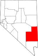 | |
| CDPs | ||
| Other unincorporated communities | ||
| Ghost towns | ||
| Footnotes | ‡This populated place also has portions in an adjacent county or counties | |