Maui County, Hawaii
| Maui County, Hawaii | |||
|---|---|---|---|
 | |||
| |||
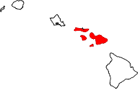 Location in the U.S. state of Hawaii | |||
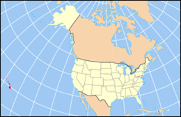 Hawaii's location in the U.S. | |||
| Founded | 1905 | ||
| Government • Mayor |
Alan Arakawa | ||
| Seat | Wailuku | ||
| Largest city | Kahului | ||
| Area | |||
| • Total | 2,398 sq mi (6,211 km2) | ||
| • Land | 1,162 sq mi (3,010 km2) | ||
| • Water | 1,237 sq mi (3,204 km2), 51.6% | ||
| Population (est.) | |||
| • (2016) | 165,386 | ||
| • Density | 133/sq mi (51/km2) | ||
| Congressional district | 2nd | ||
| Time zone | Hawaii–Aleutian: UTC−10 | ||
| Website |
www | ||

Maui County, officially the County of Maui, is a county in the U.S. state of Hawaii. It consists of the islands of Maui, Lanai, Molokai (except for a portion of Molokai that comprises Kalawao County), Kahoolawe, and Molokini. The latter two are uninhabited. As of the 2010 census, the population was 154,834.[1] The county seat is Wailuku.[2]
Maui County is included in the Kahului-Wailuku-Lahaina, HI Metropolitan Statistical Area.
Government
Maui County has a quasi-mayor-council form of municipal government. Unlike traditional municipal governments, the county government is established by the state legislature by statute and is not chartered. Executive authority is vested in the mayor, elected by the voters on a nonpartisan basis to a four-year term (with a limit of two consecutive full terms). Legislative authority is vested in the nine-member county council. All seats in the county council have residency requirements, but all Maui County voters may vote in elections for all nine seats regardless of residence. Members of the county council are elected on a nonpartisan basis to two-year terms (with a limit of five consecutive full terms).
The mayor of Maui County is Alan Arakawa since January 2, 2011. Arakawa also served as mayor from 2002 to 2006.
The county's Department of Liquor Control regulates and enforces state and county laws regarding the manufacture, importation, sale and consumption of intoxicating liquors.
Geography
According to the U.S. Census Bureau, the county has a total area of 2,398 square miles (6,210 km2), of which 1,162 square miles (3,010 km2) is land and 1,237 square miles (3,200 km2) (51.6%) is water.[3] The islands that comprise Maui County correspond to the remnants of the ancient landmass of Maui Nui. The highest point in the county is the peak of Haleakalā at 10,023 feet (3,055 m). Haleakala is a shield volcano located on the eastern side of the island of Maui.
Adjacent counties
- Hawaii County, Hawaii - southeast
- Kalawao County, Hawaiʻi - north
- Honolulu County, Hawaiʻi - northwest
National protected areas
Demographics
| Historical population | |||
|---|---|---|---|
| Census | Pop. | %± | |
| 1900 | 26,743 | — | |
| 1910 | 29,762 | 11.3% | |
| 1920 | 37,385 | 25.6% | |
| 1930 | 55,541 | 48.6% | |
| 1940 | 55,534 | 0.0% | |
| 1950 | 48,179 | −13.2% | |
| 1960 | 42,576 | −11.6% | |
| 1970 | 45,984 | 8.0% | |
| 1980 | 70,847 | 54.1% | |
| 1990 | 100,374 | 41.7% | |
| 2000 | 128,094 | 27.6% | |
| 2010 | 154,834 | 20.9% | |
| Est. 2016 | 165,386 | [4] | 6.8% |
| U.S. Decennial Census[5] 1790-1960[6] 1900-1990[7] 1990-2000[8] 2010-2016[1] | |||
As of the 2000 Census,[9] there were 128,094 people, 43,507 households, and 29,889 families residing in the county. The population density was 110 people per square mile (43/km²). There were 56,377 housing units at an average density of 49 per square mile (19/km²). The racial makeup of the county was 28.90% White, 1.40% Black or African American, 0.37% Native American, 33.01% Asian, 10.72% Pacific Islander, 1.36% from other races, and 22.24% from two or more races. 7.8% of the population were Hispanic or Latino of any race.
There were 43,507 households out of which 33.00% had children under the age of 18 living with them, 50.90% were married couples living together, 12.00% had a female householder with no husband present, and 31.30% were non-families. 21.90% of all households were made up of individuals and 6.30% had someone living alone who was 65 years of age or older. The average household size was 2.91 and the average family size was 3.41.
In the county, the population was spread out with 25.50% under the age of 18, 7.70% from 18 to 24, 30.90% from 25 to 44, 24.40% from 45 to 64, and 11.40% who were 65 years of age or older. The median age was 37 years. For every 100 females there were 100.90 males. For every 100 females age 18 and over, there were 100.20 males.
Economy
Top employers
According to the County's 2011 Comprehensive Annual Financial Report,[10] the top employers in the county are:
| # | Employer | # of Employees |
|---|---|---|
| 1 | State of Hawaii | 5,982 |
| 2 | Maui County | 2,549 |
| 3 | TS Restaurants | 1,750 |
| 4 | Grand Wailea Resort & Spa | 1,400 |
| 5 | Fairmont Hotels and Resorts | 1,220 |
| 6 | United States | 977 |
| 7 | Maui Land & Pineapple Company | 800 |
| 7 | Hyatt Regency Maui Resort & Spa | 800 |
| 8 | Four Seasons Hotels and Resorts | 650 |
| 9 | Hale Makua | 501 |
| 10 | Wailea Beach Marriott Resort & Spa | 403 |
Transportation
Airports
Three airports provide air service to the island of Maui:
- Hana Airport provides regional service to eastern Maui
- Kahului Airport in central Maui is an international airport and the island's busiest
- Kapalua Airport provides regional service to western Maui
There are also airports on Maui's smaller adjacent islands:
- Lanai Airport provides regional service to Lanai
- Molokai Airport provides regional service to Molokai
Major highways
Communities
Census-designated places
Unincorporated communities
Politics
| Year | Republican | Democratic | Others |
|---|---|---|---|
| 2016 | 25.89% 13,446 | 64.45% 33,480 | 9.66% 5,019 |
| 2012 | 23.85% 11,602 | 74.10% 36,052 | 2.05% 999 |
| 2008 | 21.54% 11,154 | 76.71% 39,727 | 1.75% 908 |
| 2004 | 38.34% 18,187 | 60.73% 28,803 | 0.93% 440 |
| 2000 | 32.81% 12,876 | 59.83% 23,484 | 7.36% 2,888 |
| 1996 | 26.74% 9,323 | 59.08% 20,600 | 14.18% 4,944 |
| 1992 | 30.17% 11,151 | 51.31% 18,962 | 18.52% 6,845 |
| 1988 | 41.96% 12,944 | 56.83% 17,532 | 1.21% 374 |
| 1984 | 52.45% 14,720 | 46.20% 12,966 | 1.36% 381 |
| 1980 | 40.23% 10,359 | 49.22% 12,674 | 10.56% 2,718 |
| 1976 | 45.78% 10,318 | 52.89% 11,921 | 1.33% 299 |
| 1972 | 61.09% 11,618 | 38.91% 7,399 | |
| 1968 | 37.76% 6,401 | 60.84% 10,313 | 1.40% 237 |
| 1964 | 21.91% 3,553 | 78.09% 12,666 | |
| 1960 | 54.79% 8,848 | 45.21% 7,302 |
Maui County was the only county in the United States won by Dennis Kucinich during his unsuccessful campaign for the Democratic Party nomination to the presidency in 2004.[12]
Sister cities
Maui County currently has 21 sister cities, including:


See also
References
- 1 2 "State & County QuickFacts". United States Census Bureau. Archived from the original on July 11, 2011. Retrieved June 28, 2014.
- ↑ "Find a County". National Association of Counties. Retrieved 2011-06-07.
- ↑ "US Gazetteer files: 2010, 2000, and 1990". United States Census Bureau. 2011-02-12. Retrieved 2011-04-23.
- ↑ "Population and Housing Unit Estimates". Retrieved June 9, 2017.
- ↑ "U.S. Decennial Census". United States Census Bureau. Retrieved June 28, 2014.
- ↑ "Historical Census Browser". University of Virginia Library. Retrieved June 28, 2014.
- ↑ "Population of Counties by Decennial Census: 1900 to 1990". United States Census Bureau. Retrieved June 28, 2014.
- ↑ "Census 2000 PHC-T-4. Ranking Tables for Counties: 1990 and 2000" (PDF). United States Census Bureau. Retrieved June 28, 2014.
- ↑ "American FactFinder". United States Census Bureau. Retrieved 2008-01-31.
- ↑ County of Maui CAFR Archived 2015-05-13 at the Wayback Machine.
- ↑ Leip, David. "Dave Leip's Atlas of U.S. Presidential Elections". uselectionatlas.org. Retrieved May 26, 2017.
- ↑ "US Election Atlas". Dave Leip. Retrieved 2008-01-11.
External links
| Wikivoyage has a travel guide for Maui. |
Places adjacent to Maui County, Hawaii | ||||||||||
|---|---|---|---|---|---|---|---|---|---|---|
| ||||||||||
Islands, municipalities, and communities of Maui County, Hawaii, United States | ||
|---|---|---|
| CDPs | | |
| Unincorporated communities | ||
| Footnotes | ‡This populated place also has portions in an adjacent county or counties | |
Honolulu (capital) | ||
| Topics | ||
| Society | ||
| Main islands | ||
| Northwestern Islands | ||
| Communities | ||
| Counties | ||
| Sovereignty Movement | ||