Roosevelt County, Montana
| Roosevelt County, Montana | |
|---|---|
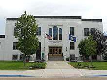 Roosevelt County Courthouse in Wolf Point | |
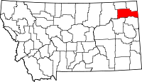 Location in the U.S. state of Montana | |
 Montana's location in the U.S. | |
| Founded | 1919 |
| Named for | Theodore Roosevelt |
| Seat | Wolf Point |
| Largest city | Wolf Point |
| Area | |
| • Total | 2,369 sq mi (6,136 km2) |
| • Land | 2,355 sq mi (6,099 km2) |
| • Water | 15 sq mi (39 km2), 0.6% |
| Population (est.) | |
| • (2015) | 11,476 |
| • Density | 4.4/sq mi (1.7/km2) |
| Congressional district | At-large |
| Time zone | Mountain: UTC−7/−6 |
| Website |
www |
Roosevelt County is a county located in the U.S. state of Montana. As of the 2010 census, the population was 10,425.[1] Its county seat is Wolf Point.[2] Roosevelt County was created by the Montana Legislature in 1919 from Sheridan County. The name honors former president Theodore Roosevelt, who had died shortly before the county was formed.[3]
Geography
According to the U.S. Census Bureau, the county has a total area of 2,369 square miles (6,140 km2), of which 2,355 square miles (6,100 km2) is land and 15 square miles (39 km2) (0.6%) is water.[4] Over 74 percent of the county's land area lies within the Fort Peck Indian Reservation.
Major highways


Adjacent counties
- Sheridan County, Montana - north
- Daniels County, Montana - north
- Valley County, Montana - west
- McCone County, Montana - southwest
- Richland County, Montana - south
- Williams County, North Dakota - east
National protected areas
Demographics
| Historical population | |||
|---|---|---|---|
| Census | Pop. | %± | |
| 1920 | 10,347 | — | |
| 1930 | 10,672 | 3.1% | |
| 1940 | 9,806 | −8.1% | |
| 1950 | 9,580 | −2.3% | |
| 1960 | 11,731 | 22.5% | |
| 1970 | 10,365 | −11.6% | |
| 1980 | 10,467 | 1.0% | |
| 1990 | 10,999 | 5.1% | |
| 2000 | 10,620 | −3.4% | |
| 2010 | 10,425 | −1.8% | |
| Est. 2016 | 11,305 | [5] | 8.4% |
| U.S. Decennial Census[6] 1790-1960[7] 1900-1990[8] 1990-2000[9] 2010-2015[1] | |||
2000 census
As of the census[10] of 2000, there were 10,620 people, 3,581 households, and 2,614 families residing in the county. The population density was 4 people per square mile (2/km²). There were 4,044 housing units at an average density of 2 per square mile (1/km²). The racial makeup of the county was 40.93% White, 0.05% Black or African American, 55.75% Native American, 0.43% Asian, 0.05% Pacific Islander, 0.25% from other races, and 2.53% from two or more races. 1.23% of the population were Hispanic or Latino of any race. 12.6% were of Norwegian and 11.5% German ancestry. 94.8% spoke English and 3.4% Dakota as their first language.
There were 3,581 households out of which 40.50% had children under the age of 18 living with them, 47.20% were married couples living together, 18.90% had a female householder with no husband present, and 27.00% were non-families. 23.60% of all households were made up of individuals and 10.30% had someone living alone who was 65 years of age or older. The average household size was 2.89 and the average family size was 3.40.
In the county, the population was spread out with 34.60% under the age of 18, 7.90% from 18 to 24, 25.80% from 25 to 44, 20.20% from 45 to 64, and 11.60% who were 65 years of age or older. The median age was 32 years. For every 100 females there were 98.30 males. For every 100 females age 18 and over, there were 93.70 males.
The median income for a household in the county was $24,834, and the median income for a family was $27,833. Males had a median income of $25,177 versus $19,728 for females. The per capita income for the county was $11,347. About 27.60% of families and 32.40% of the population were below the poverty line, including 41.60% of those under age 18 and 15.10% of those age 65 or over.
2010 census
As of the 2010 United States Census, there were 10,425 people, 3,553 households, and 2,548 families residing in the county.[11] The population density was 4.4 inhabitants per square mile (1.7/km2). There were 4,063 housing units at an average density of 1.7 per square mile (0.66/km2).[12] The racial makeup of the county was 60.4% American Indian, 35.8% white, 0.4% Asian, 0.1% black or African American, 0.2% from other races, and 3.0% from two or more races. Those of Hispanic or Latino origin made up 1.3% of the population.[11] In terms of ancestry, 20.0% were Norwegian, 16.3% were German, 6.1% were Irish, and 1.3% were American.[13]
Of the 3,553 households, 42.4% had children under the age of 18 living with them, 42.9% were married couples living together, 20.5% had a female householder with no husband present, 28.3% were non-families, and 24.2% of all households were made up of individuals. The average household size was 2.88 and the average family size was 3.41. The median age was 31.6 years.[11]
The median income for a household in the county was $37,451 and the median income for a family was $50,146. Males had a median income of $39,008 versus $34,725 for females. The per capita income for the county was $17,821. About 15.8% of families and 21.5% of the population were below the poverty line, including 28.6% of those under age 18 and 10.9% of those age 65 or over.[14]
Politics
A swing county, Roosevelt broke a nearly 30-year streak of voting Democratic in presidential elections when Donald Trump carried it with a plurality in 2016.
| Year | Republican | Democratic | Third parties |
|---|---|---|---|
| 2016 | 49.2% 1,797 | 42.7% 1,560 | 8.1% 295 |
| 2012 | 41.2% 1,514 | 56.8% 2,086 | 2.0% 72 |
| 2008 | 35.5% 1,473 | 61.7% 2,564 | 2.8% 116 |
| 2004 | 43.7% 1,762 | 54.5% 2,195 | 1.8% 71 |
| 2000 | 42.1% 1,605 | 54.0% 2,059 | 3.9% 149 |
| 1996 | 30.3% 1,209 | 53.0% 2,118 | 16.8% 670 |
| 1992 | 28.9% 1,212 | 43.6% 1,827 | 27.5% 1,154 |
| 1988 | 47.5% 1,957 | 50.6% 2,083 | 1.9% 78 |
| 1984 | 54.5% 2,431 | 44.0% 1,962 | 1.6% 71 |
| 1980 | 55.2% 2,298 | 36.2% 1,504 | 8.6% 358 |
| 1976 | 46.4% 1,822 | 52.5% 2,061 | 1.2% 45 |
| 1972 | 59.0% 2,304 | 37.5% 1,464 | 3.6% 139 |
| 1968 | 50.1% 1,947 | 45.6% 1,771 | 4.3% 167 |
| 1964 | 39.5% 1,612 | 60.4% 2,463 | 0.1% 3 |
| 1960 | 45.4% 1,876 | 53.9% 2,227 | 0.7% 29 |
| 1956 | 47.4% 1,985 | 52.6% 2,205 | 0.0% 0 |
| 1952 | 57.4% 1,998 | 42.1% 1,466 | 0.6% 19 |
| 1948 | 36.5% 1,142 | 58.2% 1,820 | 5.3% 166 |
| 1944 | 40.4% 1,281 | 58.3% 1,848 | 1.2% 39 |
| 1940 | 37.7% 1,503 | 60.7% 2,418 | 1.5% 61 |
| 1936 | 25.6% 1,052 | 71.1% 2,923 | 3.3% 134 |
| 1932 | 27.6% 965 | 64.7% 2,263 | 7.8% 272 |
| 1928 | 55.3% 1,630 | 44.0% 1,296 | 0.8% 23 |
| 1924 | 39.1% 965 | 15.8% 389 | 45.1% 1,114 |
| 1920 | 71.3% 1,624 | 24.4% 555 | 4.4% 100 |
Communities
Cities
- Poplar
- Wolf Point (county seat)
Towns
See also
References
- 1 2 "State & County QuickFacts". United States Census Bureau. Retrieved September 16, 2013.
- ↑ "Find a County". National Association of Counties. Retrieved 2011-06-07.
- ↑ "Montana Place Names Companion". Montana Place Names From Alzada to Zortman. Montana Historical Society Research Center. Retrieved 9 May 2011.
- ↑ "2010 Census Gazetteer Files". United States Census Bureau. August 22, 2012. Archived from the original on December 5, 2014. Retrieved November 29, 2014.
- ↑ "Population and Housing Unit Estimates". Retrieved June 9, 2017.
- ↑ "U.S. Decennial Census". United States Census Bureau. Retrieved November 29, 2014.
- ↑ "Historical Census Browser". University of Virginia Library. Retrieved November 29, 2014.
- ↑ "Population of Counties by Decennial Census: 1900 to 1990". United States Census Bureau. Retrieved November 29, 2014.
- ↑ "Census 2000 PHC-T-4. Ranking Tables for Counties: 1990 and 2000" (PDF). United States Census Bureau. Retrieved November 29, 2014.
- ↑ "American FactFinder". United States Census Bureau. Retrieved 2008-01-31.
- 1 2 3 "DP-1 Profile of General Population and Housing Characteristics: 2010 Demographic Profile Data". United States Census Bureau. Retrieved 2016-01-10.
- ↑ "Population, Housing Units, Area, and Density: 2010 - County". United States Census Bureau. Retrieved 2016-01-10.
- ↑ "DP02 SELECTED SOCIAL CHARACTERISTICS IN THE UNITED STATES – 2006-2010 American Community Survey 5-Year Estimates". United States Census Bureau. Retrieved 2016-01-10.
- ↑ "DP03 SELECTED ECONOMIC CHARACTERISTICS – 2006-2010 American Community Survey 5-Year Estimates". United States Census Bureau. Retrieved 2016-01-10.
- ↑ Leip, David. "Dave Leip's Atlas of U.S. Presidential Elections". uselectionatlas.org. Retrieved 2018-04-03.
Places adjacent to Roosevelt County, Montana | ||||||||||
|---|---|---|---|---|---|---|---|---|---|---|
| ||||||||||
Municipalities and communities of Roosevelt County, Montana, United States | ||
|---|---|---|
| Cities | | |
| Towns | ||
| Indian reservations | ||
| Ghost town | ||
| Footnotes | ‡This populated place also has portions in an adjacent county or counties | |
