Spring Valley, Nevada
| Spring Valley, Nevada | |
|---|---|
| Unincorporated town | |
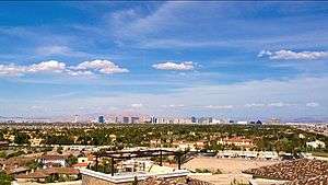 Spring Valley, as seen from the affluent Spanish Hills community, 2016. The Las Vegas Strip is in the background. | |
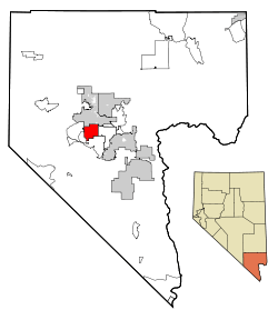 Location of Spring Valley in Clark County, Nevada | |
 Spring Valley, Nevada Location in the United States | |
| Coordinates: 36°6′45″N 115°15′1″W / 36.11250°N 115.25028°W | |
| Country | United States |
| State | Nevada |
| County | Clark |
| Government | |
| • Type | Advisory Board |
| • Commissioner | Steve Sisolak |
| Area | |
| • Total | 33.4 sq mi (86.4 km2) |
| • Land | 33.4 sq mi (86.4 km2) |
| • Water | 0.0 sq mi (0.0 km2) |
| Elevation | 2,365 ft (721 m) |
| Population (2010 Census) | |
| • Total | 178,395 |
| • Density | 5,300/sq mi (2,100/km2) |
| Time zone | UTC-8 (PST) |
| • Summer (DST) | UTC-7 (PDT) |
| FIPS code | 32-68585 |
| GNIS feature ID | 1867350 |
| Website |
sites |
Spring Valley is an unincorporated town[1] and census-designated place and part of Las Vegas Township in Clark County, Nevada, United States, located 2 miles (3 km) west of the Las Vegas Strip. The population was 178,395 at the 2010 census.[2] Spring Valley was formed in May, 1981.[3]
History
The land was previously occupied by Stardust International Raceway.[4] Pardee Homes purchased the land in the mid-1970s and began developing a master-planned housing community called Spring Valley. The community was named by Doug Pardee and sales manager Jack Whiteman, in reference to its views of the Spring Mountains and its location in the Las Vegas Valley.[5] In 1981, residents grouped together to solicit the Clark County Commission to create an unincorporated town, which it did that May. The town originally encompassed 1 square mile (3 km2), but now occupies much of the southwest quarter of the Las Vegas Valley, totaling 33.4 square miles (90 km2).
Geography
According to the United States Census Bureau, the census-designated place (CDP) of Spring Valley (which may not exactly coincide with the town boundaries) has a total area of 33.4 sq mi (87 km2), all of it land.
The predominant boundaries of Spring Valley are Sahara Avenue on the north, Decatur Boulevard on the east, Warm Springs Road on the south, and Hualapai Way on the west.
The area mostly consists of housing subdivisions, with strip malls lining the large boulevards that connect suburban Las Vegas to the Strip. The northern part of Spring Valley includes areas of rural-estate zoning, with large parcels of land on blocks of 1⁄64 square mile (40,000 m2). The southern part of Spring Valley is quickly developing – fifteen years ago, very little south of Tropicana Avenue was developed within Spring Valley.
A large park, Desert Breeze Park, is located in the north-central part of the town. Next to that park is the prestigious Roger M. Bryan Elementary School.
Demographics
| Historical population | |||
|---|---|---|---|
| Census | Pop. | %± | |
| 1990 | 51,726 | — | |
| 2000 | 117,390 | 126.9% | |
| 2010 | 178,395 | 52.0% | |
| source:[6] | |||
At the census of 2010,[7] there were 178,395 people residing in the CDP. The racial makeup was 57.9% White, 9.8% African American, 0.6% Native American, 17.4% Asian, 0.8% Pacific Islander, and 5.0% from two or more races. Hispanic or Latino of any race were 20.6% of the population and 48.1% of the population was non-Hispanic White.
As of the census of 2000, there were 117,390 people, 47,964 households, and 29,929 families residing in the CDP. The population density was 3,519.4/sq mi (1,358.8/km2). There were 52,870 housing units at an average density of 1,585/sq mi (612/km2). The racial makeup of the CDP was 72.60% White, 5.29% African American, 0.60% Native American, 11.21% Asian, 0.48% Pacific Islander, 5.14% from other races, and 4.67% from two or more races. Hispanic or Latino of any race were 13.77% of the population.
There were 47,964 households out of which 27.0% had children under the age of 18 living with them, 46.7% were married couples living together, 10.5% had a female householder with no husband present, and 37.6% were non-families. 25.9% of all households were made up of individuals and 5.9% had someone living alone who was 65 years of age or older. The average household size was 2.44 and the average family size was 2.98.
In the CDP, the population was spread out with 21.2% under the age of 18, 9.4% from 18 to 24, 33.7% from 25 to 44, 25.0% from 45 to 64, and 10.7% who were 65 years of age or older. The median age was 36 years. For every 100 females, there were 99.6 males. For every 100 females age 18 and over, there were 98.4 males.
The median income for a household in the CDP was $48,563, and the median income for a family was $55,021. Males had a median income of $37,068 versus $28,288 for females. The per capita income for the CDP was $26,321. About 4.8% of families and 6.7% of the population were below the poverty line, including 6.9% of those under age 18 and 7.7% of those age 65 or over.
Culture
Residents
Spring Valley is the home of tennis players Andre Agassi and Steffi Graf, as well as former Sacramento Kings owners George J. Maloof, Jr.. The Sultan of Brunei keeps a residence there at 99 Spanish Gate Drive, and Carrot Top has his Las Vegas residence in the area. Blogger and reality TV personality J.Son Dinant resides in Spring Valley. NASCAR drivers Kurt and Kyle Busch attended Durango High School in Spring Valley, as did actress Cerina Vincent and BMX celebrity T. J. Lavin. Kris Bryant lived in Spring Valley and went to the prestigious 5 stars school Clifford J. Lawrence Junior High School.
Chinatown
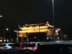
Spring Mountain Road and surrounding streets, from Valley View to Jones Boulevard in Spring Valley and a part of Paradise, is a series of strip malls with ethnic Chinese and other pan-Asian businesses, with the original called Chinatown Plaza. Historically, the strip mall was conceived by Taiwanese American JHK Investment Group, Inc. and opened in 1995. Nevada Governor Kenny Guinn officially designated the area as Chinatown in October 1999 and it continues to grow as the Asian population in Las Vegas expands rapidly. The Chinatown area has gained much popularity, receiving national attention in a 2004 article by The Wall Street Journal (See Further Reading below for the specific citation). Huffington Post classifies Las Vegas Chinatown along with Atlanta-Chamblee, Dallas-Richardson, and North Miami Beach as a "modern" styled Chinatown, that contrasts with the historic core Chinatowns like New York and San Francisco.[8] The Chinatown is pan-Asian in nature instead of being completely Chinese according to the previous source. The official website for the Chinatown Plaza indicates that Spring Mountain Road is the general corridor for the neighborhood.[9]
The history of Chinese population in the Las Vegas Valley shows that the Chinese population remained small throughout most of its history. As a result, a Chinatown could only be created with initiative from entrepreneurs that would in essence fabricate a scenario that came naturally in other large cities that have historically important Chinatowns.[10] According to Tsui in her book, Las Vegas's Chinese population boomed starting from the 1960s and by the 1990s, the Chinese population grew to 15,000 with the majority working in the casino industry. Even as the population grew, the "Chinatown experiment" could not rely on the local Chinese population to create it, but relied on a label on the plaza itself before people knew it was "Chinatown". As a saleswoman visiting the Chinatown answered "How do I know this is Chinatown?" Her answer was "Because it says so right on the arch, in Chinese characters (Zhongguo Cheng)"[11]
According to Tsui's book, Senator Harry Reid "... ordered a sign to be put up for Chinatown [along Interstate 15]..." but was taken down by the order of the governor of Nevada Bob Miller. In 1996, the Clark County, Nevada designated the area as "Chinatown".[11]
To date, Chinatown Vegas has over 150+ restaurants, 50 foot reflexology[12] and massages spas, 6 large Asian Supermarkets and more than one dozen Chinese and Asian churches.
Education
All public schools within Spring Valley are part of the Clark County School District.
Elementary Schools
- Roger M. Bryan Elementary School
- Patricia A. Bendorf Elementary School
- C.H. Decker Elementary School
- Harvey Dondero Elementary School
- Marion Earl Elementary School
- Wayne Tanaka Elementary School
- Pat Diskin Elementary School
Middle Schools
- Wilbur and Theresa Faiss Middle School
- Victoria Fertitta Middle School
- Kenny Guinn Middle School
- Clifford J. Lawrence Middle School
- Grant Sawyer Middle School
- Canarelli Middle School
High Schools
- Durango High School
- Spring Valley High School
- Bonanza High School
- Ed. W Clark High School
- Sierra Vista High School (Nevada)
Government
Spring Valley's municipal government is the Clark County Commission, which has seven members from across Southern Nevada (and none of whom resided in Spring Valley as of 2006). A five-member Town Advisory Board offers advisory opinions on zoning and business matters to the commission, but the commission is not obligated to respond or be held to those suggestions.
Most of Spring Valley falls within Nevada's 1st Congressional District, but portions west of Durango and south of Russell are within the 3rd District.
References
- ↑ "Archived copy". Archived from the original on 2015-09-05. Retrieved 2015-10-07.
- ↑ "Profile of General Population and Housing Characteristics: 2010 Demographic Profile Data (DP-1): Spring Valley CDP, Nevada". U.S. Census Bureau, American Factfinder. Retrieved March 13, 2012.
- ↑ Steve Kanigher (July 18, 2003). "Las Vegas: Bright lights, but not a big city". Las Vegas Sun. Retrieved October 8, 2012.
- ↑ "Stardust memories". Las Vegas Sun. May 22, 2003. Retrieved 7 December 2009.
- ↑ F. Andrew Taylor (August 3, 2010). "Origin of many Clark County township names is a mystery". Anthem View. Las Vegas – via NewsBank.
- ↑ "CENSUS OF POPULATION AND HOUSING (1790-2000)". U.S. Census Bureau. Retrieved 2010-07-17.
- ↑ "Archived copy". Archived from the original on 2015-09-05. Retrieved 2015-07-01.
- ↑ "The Best Chinese Probably Isn't In Chinatown". Huffington Post. December 4, 2012.
- ↑ "Las Vegas Chinatown".
- ↑ Las Vegas: A Pictorial Celebration.
- 1 2 Bonnie Tsui. American Chinatown: A People's History of Five Neighborhoods.
- ↑ "Chinatown Vegas Massage - Chinatown Report". Chinatown Report. Retrieved 2018-08-25.
External links
- Official website

- The Spring Valley land-use plan, which includes information on its boundaries
- Spring Valley Town Advisory Board
Coordinates: 36°6′45″N 115°15′1″W / 36.11250°N 115.25028°W
Places adjacent to Spring Valley, Nevada | ||||||||||
|---|---|---|---|---|---|---|---|---|---|---|
| ||||||||||
Municipalities and communities of Clark County, Nevada, United States | ||
|---|---|---|
| Cities |  | |
| CDPs | ||
| Unincorporated communities | ||
| Township | ||
| Ghost towns | ||
| Indian reservations | ||
| Footnotes | ‡This populated place also has portions in an adjacent county or counties | |
Carson City (capital) | ||
| Topics |
|  |
| Society | ||
| Regions | ||
| Metro areas | ||
| Counties | ||
| Cities and communities |
| |
| Former counties | ||