Las Vegas–Paradise, NV MSA
| Las Vegas–Paradise–Henderson Metropolitan Statistical Area | |
|---|---|
| MSA | |
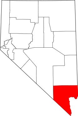 Map of Nevada with the MSA (same area as Clark County) highlighted in red |
The Las Vegas–Paradise, NV MSA, also known as the Las Vegas–Henderson–Paradise, NV Metropolitan Statistical Area (2013), is in the southern part of the U.S. state of Nevada, coextensive since 2003 with Clark County, Nevada.[1] A central part of the metropolitan area is the Las Vegas Valley, a 600 sq mi (1,600 km2) basin that includes the metropolitan area's largest city, Las Vegas as well as the other primary city, Paradise, Nevada. The area contains the largest concentration of people in the state. Cities in the metropolitan area include Las Vegas, Henderson, North Las Vegas, and Boulder City. The metropolitan area is one of the top tourist destinations in the world, drawing over 40 million international and domestic visitors in 2013 with a GMP of US$103.3 billion.[2][3]
History
The metropolitan area was created for the 1970 census when it only included Clark County. In 2000, the metropolitan area was changed to include Nye County, Nevada and Mohave County, Arizona.[4][5][6] This area appears to have existed since at least 1967 when the census bureau defined the SMSAs outside New England as "a county or group of contiguous counties which contains at least one city of 50,000 inhabitants in addition to the county or counties containing such a city or cities, contiguous counties are included in an SMSA if, according to certain criteria, they are socially and economically integrated with the central city."[7]
Demographics
| Historical population | |||
|---|---|---|---|
| Census | Pop. | %± | |
| 1960 | 127,016 | — | |
| 1970 | 273,288 | 115.2% | |
| 1980 | 528,000 | 93.2% | |
| 1990 | 852,737 | 61.5% | |
| 2000 | 1,375,765 | 61.3% | |
| 2010 | 1,951,269 | 41.8% | |
| [8] | |||
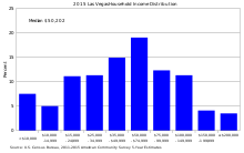
.png)
As of the census[10] of 2000, there were 1,375,765 people, 512,253 households, and 339,693 families residing within the MSA. The racial makeup of the MSA was 71.6% White (60.2% White Non-Hispanic), 9.1% Black, 5.7% Asian, 0.8% American Indian and 12.8% of other or mixed race. 22.0% were Hispanic of any race. In 2009, the population in the metropolitan area had grown up to 1,902,834 people, and by 2017, the metropolitan population is estimated to have grown to 2,248,390 people, being one of the fastest growing MSA's in the United States.
In 1999, the median income for a household in the MSA was $44,616 and the median income for a family was $50,485. The per capita income was $21,785.
The United States Census Bureau 2009 estimates place the population for the Las Vegas Metropolitan Statistical Area at 1,902,834 people, and the region is one of the fastest growing in the United States.[11] Large numbers of new residents in the state originate from California.[12]
Office of Management and Budget definition
The Office of Management and Budget has designated Clark County as the Las Vegas-Henderson-Paradise, NV Metropolitan Statistical Area.[13] The United States Census Bureau ranked the Las Vegas-Henderson-Paradise, NV Metropolitan Statistical Area as the 31st most populous metropolitan statistical area of the United States as of July 1, 2012.[14]
The Office of Management and Budget has further designated the Las Vegas-Henderson-Paradise, NV Metropolitan Statistical Area as a component of the more extensive Las Vegas–Henderson, NV–AZ CSA,[13] the 27th most populous combined statistical area and the 30th most populous primary statistical area of the United States as of July 1, 2012.[14][15]
Tourism
In 2011, the majority of tourists arrived from the western states (55%) with 31% from California alone. Approximately 16% of tourists arrived from outside North America.[16]
References
- ↑ "Metropolitan Statistical Areas and Components, December 2005, with codes". Archived from the original on 2006-02-09. Retrieved 2007-03-23.
- ↑ "Overseas Visitation Estimates for U.S. States, Cities, and Census Regions: 2011" (PDF). International Visitation in the United States. US Office of Travel and Tourism Industries, US Department of Commerce. May 2012. Retrieved November 12, 2012.
- ↑ "Archived copy" (PDF). Archived from the original (PDF) on 2015-03-05. Retrieved 2015-02-01.
- ↑ "County Composition of Metropolitan Areas: 1940-2006". Minnesota Population Center, University of Minnesota. Retrieved June 22, 2012.
- ↑ "2001 Metropolitan Area Occupational Employment and Wage Estimates Las Vegas, NV-AZ MSA". U.S. Bureau of Labor Statistics. December 5, 2002. Retrieved April 23, 2012.
- ↑ "Metropolitan Areas: Concepts, Components, and Population" (PDF). U.S. Census Bureau. 1999. Retrieved June 18, 2012.
- ↑ "Census Tracts" (PDF). U.S. Census Bureau. 1999. Retrieved June 18, 2012.
- ↑ "1990 CPH-S-1-1" (PDF). U.S. Department of Commerce. Retrieved June 22, 2012.
- ↑ "Household Income Distribution in Las Vegas". American Fact Finder. US Census Breau. Retrieved May 4, 2018.
- ↑ "American FactFinder". United States Census Bureau. Archived from the original on 2013-09-11. Retrieved 2008-01-31.
- ↑ "Estimates of Population Change for Metropolitan Statistical Areas and Rankings: July 1, 2008 to July 1, 2009". U.S. Census Bureau. April 2009. Archived from the original on 2010-06-15. Retrieved October 26, 2010.
- ↑ "About.com". Usgovinfo.about.com. 2010-06-19. Retrieved 2011-02-20.
- 1 2 "OMB Bulletin No. 13-01: Revised Delineations of Metropolitan Statistical Areas, Micropolitan Statistical Areas, and Combined Statistical Areas, and Guidance on Uses of the Delineations of These Areas" (PDF). United States Office of Management and Budget. February 28, 2013. Archived from the original (PDF) on March 19, 2013. Retrieved March 20, 2013.
- 1 2 "Table 1. Annual Estimates of the Population of Metropolitan and Micropolitan Statistical Areas: April 1, 2010 to July 1, 2012". 2012 Population Estimates. United States Census Bureau, Population Division. March 2013. Archived from the original (CSV) on April 1, 2013. Retrieved March 20, 2013.
- ↑ "Table 2. Annual Estimates of the Population of Combined Statistical Areas: April 1, 2010 to July 1, 2012". 2012 Population Estimates. United States Census Bureau, Population Division. March 2013. Archived from the original (CSV) on May 17, 2013. Retrieved March 20, 2013.
- ↑ "LAS VEGAS VISITOR PROFILE" (PDF). Las Vegas Convention and Visitors Authority (GLS Research). Retrieved November 19, 2012.
Coordinates: 36°07′54″N 115°11′03″W / 36.131803°N 115.184034°W