Bandera County, Texas
| Bandera County, Texas | |
|---|---|
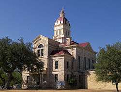 The Bandera County Courthouse in Bandera. The building was added to the National Register of Historic Places on October 31, 1979. | |
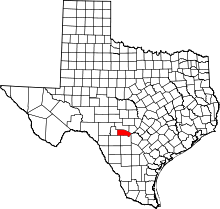 Location in the U.S. state of Texas | |
 Texas's location in the U.S. | |
| Founded | 1856 |
| Named for | Bandera Pass |
| Seat | Bandera |
| Largest community | Lakehills |
| Area | |
| • Total | 798 sq mi (2,067 km2) |
| • Land | 791 sq mi (2,049 km2) |
| • Water | 6.7 sq mi (17 km2), 0.8% |
| Population | |
| • (2010) | 20,485 |
| • Density | 26/sq mi (10/km2) |
| Congressional district | 21st |
| Time zone | Central: UTC−6/−5 |
| Website |
www |
Bandera County is a county located on the Edwards Plateau in the U.S. state of Texas. As of the 2010 census, the population is 20,485.[1] Its county seat is Bandera.[2] The county was formed in 1856 from Bexar and Uvalde counties. The county and its seat are named for Bandera Pass, which in turn uses the Spanish word for flag.
Bandera County is part of the San Antonio-New Braunfels, TX Metropolitan Statistical Area. The county is officially recognized as the "Cowboy Capital of the World" by the Texas Legislature.[3]
History
- 8000 to 4000 BC Earliest human habitation.
- In the 17th century Native Americans settled including Lipan Apache and later, Comanche.[4]
- 1841 or 1843 (exact date uncertain) – Battle of Bandera Pass, John Coffee Hays and a troupe of Texas Rangers defeat a large party of Comanche warriors.[5][6][7]
- 1853 John James and Charles S. DeMontel[8] survey and plan the town of Bandera. A. M. Milstead, Thomas Odem, P.D. Saner, and their families camp along the river and begin making cypress shingles. James, Montel and Company build a horse-powered sawmill and open a store.[4][9]
- 1855 Sixteen Polish families arrive in Bandera to work in James and DeMontel's sawmill. August Klappenbach opens the first store and post office.[4]
- 1856 The legislature marks off Bandera County from portions of Bexar County, and the county is formally organized.[4]
- 1860 Population 399, including 12 slaves.[4]
- 1880 Sheep and Angora goats become more profitable for Bandera than farming.[4]
- 1920 Cora and Ed Buck began taking boarders at their ranch, beginning the tourist trade in Bandera.[10][11]
- 1933 Frontier Times Museum[12] opens to the public.[13]
- 1979 Lost Maples State Natural Area opens to the public.[14]
- 1982 Eighty-two percent of the land in the county is in farms and ranches.[4]
- 1984 Hill Country State Natural Area[15] opens to the public.[16]
- 2000 The Nature Conservancy purchases 1,400 acres (5.7 km2) of Love Creek Ranch[17] from Baxter and Carol Adams, creating the Love Creek Preserve.[18]
Geography
According to the U.S. Census Bureau, the county has a total area of 798 square miles (2,070 km2), of which 791 square miles (2,050 km2) is land and 6.7 square miles (17 km2) (0.8%) is water.[19]
Major highways
Adjacent counties
- Kerr County (north)
- Kendall County (northeast)
- Bexar County (southeast)
- Medina County (south)
- Uvalde County (southwest)
- Real County (west)
Demographics
| Historical population | |||
|---|---|---|---|
| Census | Pop. | %± | |
| 1860 | 399 | — | |
| 1870 | 649 | 62.7% | |
| 1880 | 2,158 | 232.5% | |
| 1890 | 3,795 | 75.9% | |
| 1900 | 5,332 | 40.5% | |
| 1910 | 4,921 | −7.7% | |
| 1920 | 4,001 | −18.7% | |
| 1930 | 3,784 | −5.4% | |
| 1940 | 4,234 | 11.9% | |
| 1950 | 4,410 | 4.2% | |
| 1960 | 3,892 | −11.7% | |
| 1970 | 4,747 | 22.0% | |
| 1980 | 7,084 | 49.2% | |
| 1990 | 10,562 | 49.1% | |
| 2000 | 17,645 | 67.1% | |
| 2010 | 20,485 | 16.1% | |
| Est. 2017 | 22,351 | [20] | 9.1% |
| U.S. Decennial Census[21] 1850–2010[22] 2010–2014[1] | |||
As of the 2010 United States Census, there were 20,485 people residing in the county. 92.8% were White, 0.8% Native American, 0.5% Black or African American, 0.3% Asian, 3.8% of some other race and 1.8% of two or more races. 16.7% were Hispanic or Latino (of any race). 17.6% were of German, 13.7% English, 10.2% Irish and 10.1% American ancestry.[23]
As of the census[24] of 2000, there were 17,645 people, 7,010 households, and 5,061 families residing in the county. The population density was 22 people per square mile (9/km²). There were 9,503 housing units at an average density of 12 per square mile (5/km²). The racial makeup of the county was 94.02% White, 0.33% Black or African American, 0.90% Native American, 0.28% Asian, 0.06% Pacific Islander, 2.55% from other races, and 1.86% from two or more races. 13.51% of the population were Hispanic or Latino of any race.
There were 7,010 households out of which 29.10% had children under the age of 18 living with them, 60.80% were married couples living together, 7.30% had a female householder with no husband present, and 27.80% were non-families. 23.20% of all households were made up of individuals and 9.90% had someone living alone who was 65 years of age or older. The average household size was 2.49 and the average family size was 2.92.
In the county, the population was spread out with 24.70% under the age of 18, 5.80% from 18 to 24, 25.70% from 25 to 44, 27.60% from 45 to 64, and 16.20% who were 65 years of age or older. The median age was 41 years. For every 100 females, there were 99.00 males. For every 100 females age 18 and over, there were 98.30 males.
The median income for a household in the county was $39,013, and the median income for a family was $45,906. Males had a median income of $31,733 versus $24,451 for females. The per capita income for the county was $19,635. About 7.70% of families and 10.80% of the population were below the poverty line, including 12.20% of those under age 18 and 9.40% of those age 65 or over.
Education
The following school districts serve Bandera County:
Communities
City
- Bandera (county seat)
Census-designated places
- Lake Medina Shores (partly in Medina County)
- Lakehills (largest community)
Unincorporated communities
Politics
| Year | Republican | Democratic | Third parties |
|---|---|---|---|
| 2016 | 79.9% 8,163 | 16.9% 1,726 | 3.2% 329 |
| 2012 | 78.6% 7,426 | 19.7% 1,864 | 1.7% 158 |
| 2008 | 74.6% 6,935 | 24.2% 2,250 | 1.2% 112 |
| 2004 | 79.3% 6,933 | 19.9% 1,738 | 0.8% 70 |
| 2000 | 77.2% 5,613 | 19.6% 1,426 | 3.2% 234 |
| 1996 | 65.2% 3,700 | 24.4% 1,383 | 10.4% 590 |
| 1992 | 50.2% 2,674 | 19.9% 1,059 | 29.9% 1,589 |
| 1988 | 72.2% 3,435 | 26.3% 1,251 | 1.6% 75 |
| 1984 | 80.0% 3,152 | 19.6% 771 | 0.4% 15 |
| 1980 | 70.6% 2,373 | 26.6% 894 | 2.8% 93 |
| 1976 | 56.2% 1,554 | 42.8% 1,183 | 1.1% 29 |
| 1972 | 79.5% 1,796 | 19.2% 434 | 1.3% 29 |
| 1968 | 46.8% 842 | 29.7% 535 | 23.5% 423 |
| 1964 | 46.5% 762 | 53.5% 876 | 0.1% 1 |
| 1960 | 63.5% 942 | 36.3% 539 | 0.2% 3 |
| 1956 | 76.1% 1,083 | 23.6% 336 | 0.4% 5 |
| 1952 | 79.0% 1,350 | 20.9% 358 | 0.1% 2 |
| 1948 | 50.4% 570 | 39.3% 445 | 10.3% 117 |
| 1944 | 50.4% 634 | 42.3% 532 | 7.3% 92 |
| 1940 | 32.8% 432 | 66.9% 881 | 0.3% 4 |
| 1936 | 36.8% 431 | 61.5% 720 | 1.7% 20 |
| 1932 | 28.7% 359 | 70.7% 883 | 0.6% 7 |
| 1928 | 74.5% 936 | 25.2% 317 | 0.2% 3 |
| 1924 | 47.8% 442 | 46.0% 425 | 6.2% 57 |
| 1920 | 40.8% 249 | 50.9% 311 | 8.4% 51 |
| 1916 | 22.3% 168 | 71.4% 537 | 6.3% 47 |
| 1912 | 22.3% 158 | 58.0% 412 | 19.7% 140 |
See also
References
- 1 2 "State & County QuickFacts". United States Census Bureau. Retrieved December 8, 2013.
- ↑ "Find a County". National Association of Counties. Archived from the original on 2011-05-31. Retrieved 2011-06-07.
- ↑ Pannebaker, Judith (July 11, 2013). "Bandera now official 'Cowboy Capital of the World'". Bandera County Courier. Retrieved July 16, 2013.
- 1 2 3 4 5 6 7 Long, Christopher. "Bandera County, Texas". Handbook of Texas Online. Texas State Historical Association. Archived from the original on December 21, 2010. Retrieved November 28, 2010.
- ↑ Fisher, O Clark (1966). "Battle of Bandera Pass". Great Western Indian Fights. Bison. p. 41. ISBN 978-0-8032-5186-1.
- ↑ Tobin, Peggy. "Battle of Bandera Pass". Handbook of Texas Online. Texas State Historical Association. Retrieved November 28, 2010.
- ↑ McConnell, Joseph Caroll. "Famous Battle of Bandera Pass". Fort Tours. Fort Tour Systems, Inc. Archived from the original on November 25, 2010. Retrieved November 28, 2010.
- ↑ Schumacher, Dr MJ (5 November 2009). "Granddaughter's memories bring early history to life". Bandera County Courier.
- ↑ Tobin, Peggy. "Bandera, Texas". Handbook of Texas Online. Texas State Historical Association. Archived from the original on November 1, 2010. Retrieved November 28, 2010.
- ↑ Wise, Dan (July 25, 2006). "Celebrate Bandera County honors Bandera County's dude ranches". The Bandera Bulletin.
- ↑ "Old Buck Ranch". Texas State Historical Markers. William Nienke, Sam Morrow. Archived from the original on March 1, 2012. Retrieved November 28, 2010.
- ↑ Pohlen, Jerome (2006). "Frontier Times Museum". Oddball Texas: A Guide to Some Really Strange Places. Chicago Review Press. pp. 140–141. ISBN 978-1-55652-583-4.
- ↑ "Frontier Times Museum". Texas State Historical Markers. William Nienke, Sam Morrow. Archived from the original on March 14, 2012. Retrieved November 28, 2010.
- ↑ "Lost Maples State Park". Texas Parks and Wildlife Department. Retrieved November 28, 2010.
- ↑ Coppedge, Clay. "Bandera-Hill Country State Natural Preserve". Texas Escapes. Texas Escapes - Blueprints For Travel, LLC. Retrieved November 28, 2010.
- ↑ "Hill Country State Natural Area". Texas Parks and Wildlife Department. Archived from the original on October 28, 2010. Retrieved November 28, 2010.
- ↑ Permenter, Paris; Bigley, John (2006). Day Trips from San Antonio. GPP Travel. p. 149. ISBN 978-0-7627-3868-7.
- ↑ "Love Creek Preserve". The Nature Conservancy. Retrieved November 28, 2010.
- ↑ "2010 Census Gazetteer Files". United States Census Bureau. August 22, 2012. Retrieved April 19, 2015.
- ↑ "Population and Housing Unit Estimates". Retrieved June 9, 2017.
- ↑ "U.S. Decennial Census". United States Census Bureau. Archived from the original on May 12, 2015. Retrieved April 19, 2015.
- ↑ "Texas Almanac: Population History of Counties from 1850–2010" (PDF). Texas Almanac. Retrieved April 19, 2015.
- ↑ "American FactFinder"
- ↑ "American FactFinder". United States Census Bureau. Archived from the original on 2013-09-11. Retrieved 2011-05-14.
- ↑ Leip, David. "Dave Leip's Atlas of U.S. Presidential Elections". uselectionatlas.org. Retrieved 2018-07-19.
External links
- Bandera County government
- Bandera County Chamber of Commerce
- Bandera County Convention and Visitor Bureau
- Bandera County, Texas from the Handbook of Texas Online
- Bandera County from the Texas Almanac
- Bandera County from the TXGenWeb Project
- Pioneer history of Bandera County: seventy-five years of intrepid history, published 1922, hosted by The Portal to Texas History
Places adjacent to Bandera County, Texas | ||||||||||
|---|---|---|---|---|---|---|---|---|---|---|
| ||||||||||
Municipalities and communities of Bandera County, Texas, United States | ||
|---|---|---|
| City | | |
| CDPs | ||
| Unincorporated communities | ||
| Footnotes | ‡This city also has portions in an adjacent county or counties | |
