Laoag
Laoag, officially the City of Laoag (Ilocano: Siudad ti Laoag), or simply known as Laoag City is a 3rd class component city and capital of the province of Ilocos Norte, Philippines.
Laoag | |
|---|---|
| City of Laoag | |
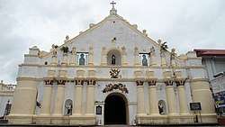  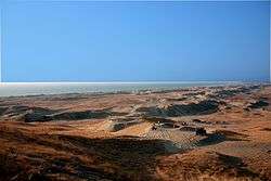 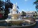  From top, left to right: Façade of Laoag Cathedral, Exterior of Laoag International Airport, La Paz Sand Dunes, Aurora Park, Sinking bell tower of Laoag | |
 Seal | |
| Nickname(s): The Sunshine City | |
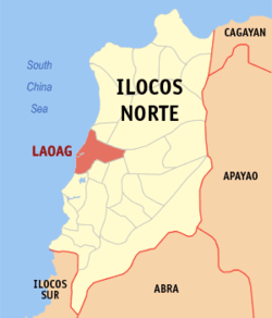 Map of Ilocos Norte with Laoag highlighted | |
OpenStreetMap 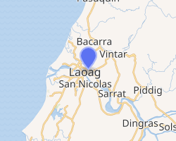
| |
.svg.png) Laoag Location within the Philippines | |
| Coordinates: 18°12′N 120°36′E | |
| Country | |
| Region | Ilocos Region (Region I) |
| Province | Ilocos Norte |
| District | 1st District |
| Founded | 1580 |
| Cityhood | 19 June 1965 |
| Barangays | 80 (see Barangays) |
| Government | |
| • Type | Sangguniang Panlungsod |
| • Mayor | Michael Marcos Keon |
| • Vice Mayor | Vicentito M. Lazo |
| • Congressman | Ria Christina G. Fariñas |
| • Electorate | 78,731 voters (2019) |
| Area | |
| • Total | 116.08 km2 (44.82 sq mi) |
| Elevation | 12.5 m (41.0 ft) |
| Population (2015 census)[3] | |
| • Total | 111,125 |
| • Density | 960/km2 (2,500/sq mi) |
| • Households | 23,229 |
| Economy | |
| • Income class | 3rd city income class |
| • Poverty incidence | 6.61% (2015)[4] |
| • Revenue (₱) | 636,971,584.19 (2016) |
| Time zone | UTC+8 (PST) |
| ZIP code | 2900 |
| PSGC | |
| IDD : area code | +63 (0)77 |
| Climate type | tropical monsoon climate |
| Native languages | Ilocano Tagalog |
| Website | www |
It is the province's political, commercial, and industrial hub and the location of the Ilocos Region's busiest commercial airport.
The municipalities of San Nicolas, Paoay, Sarrat, Vintar, and Bacarra form its boundaries. The foothills of the Cordillera Central mountain range to the east, and the West Philippine Sea to the west are its physical boundaries.
Laoag experiences the prevailing monsoon climate of Northern Luzon, characterized by a dry season from November to April and a wet season from May to October, occasionally visited by powerful typhoons.
History
Long before the coming of the Spaniards, there already existed an extensive region consisting of the present provinces of Ilocos Norte, Ilocos Sur, Abra and La Union renowned for its gold mines. Merchants from Japan and China would often visit the area to trade gold with beads, ceramics and silk. The Austronesian inhabitants of the region called their place samtoy, from sao mi itoy, which literally meant "this is our language."
In 1571, when the Spanish conquistadors had Manila more or less under their control, they began looking for new sites to conquer. Legaspi's grandson, Juan de Salcedo, volunteered to lead one of these expeditions. Together with eight armed boats and 45 men, the 22-year-old voyager headed north.
On June 13, 1572, Salcedo and his men landed in Vigan and then proceeded towards Laoag, Currimao, and Badoc. As they sailed along the coast, they were surprised to see numerous sheltered coves (looc) where the locals lived in harmony. As a result, they named the region "Ylocos" and its people "Ylocanos".
As the Christianization of the region grew, so did the landscape of the area. Vast tracts of land were utilized for churches and bell towers in line with the Spanish mission of bajo de las campanas ('under the bells') – a proclamation by King Philip's 1573 Law of the Indies. In the town plaza, it was not uncommon to see garrisons under the church bells. The colonization process was slowly being carried out.
The Spanish colonization of the region, however, was never completely successful. Owing to the abusive practices of many Augustinian friars, a number of Ilocanos revolted against their colonizers. Noteworthy of these were the Dingras uprising (1589) and Pedro Almasan revolt in San Nicolas (1660). In 1762, Diego Silang led a series of battles aimed at freeing the Ilocanos from the Spanish yoke. When he died from an assassin's bullet, his widow Gabriela continued the cause. Unfortunately, she too was captured and hanged. In 1807, the sugar cane (basi) brewers of Piddig rose up in arms to protest the government's monopoly of the wine industry. In 1898, the church excommunicated Gregorio Aglipay for refusing to cut off ties with the revolutionary forces of Gen. Emilio Aguinaldo. Unperturbed, he established the Iglesia Filipina Independiente. Aglipay's movement and the national sentiment it espoused helped restore the self-respect of many Filipinos.

"The great increase in population from 1715 to 1818 from 18,980 to 282,845 made the administration of the province very difficult. Due to the excessive monopolies and forced labor, there were several uprisings: first by the people of Dingras in 1589; one that was led by Pedro Almazan in 1616; the revolt of Diego Silang in 1762–1763; by Ambaristo in 1788; by Pedro Mateo in 1808 (also known as Basi Revolt) and uprising of Sarrat in 1815. For this reason, the division of the Ilocos into two provinces was recommended by the local authorities. On February 2, 1818, a Spanish Royal Decree was promulgated dividing the Province of Ilocos Norte from Ilocos Sur. Laoag City, which was then the biggest center of population, was made the capital of Ilocos Norte."[5]
On June 19, 1965, Laoag changed from municipality to city status, following a plebiscite and passed into law by the Senate President Ferdinand Edralin Marcos. It remained the capital of Ilocos Norte. Mayor Eulalio F. Siazon and Engineer Trinidad Lucas Aurelio were part of a team that led the drive to convert Laoag into a city. Another membes of the group was Simeon M. Valdez who filed the bill in congress, co-authored by Antonio V. Raquiza. The first city mayor was Eulalio Fariñas Siazon.[6]
Geography
Laoag is located at the west-central part of the Province of Ilocos Norte bordering the West Philippine Sea. It is bounded on the east by the Municipality of Sarrat; in the southeast by the Municipality of San Nicolas; in the southwest by the Municipality of Paoay, in the northeast the Municipality of Vintar; in the northwest by the Municipality of Bacarra; and in the west by the South China Sea. It is one of the largest cities in the Ilocos Region.[7]
Barangays
| Conventional Long Name | Barangay Number | Name | Former Name/Territory |
|---|---|---|---|
| Barangay No. 1, San Lorenzo (Poblacion) | 1 | San Lorenzo | Poblacion |
| Barangay No. 2, Santa Joaquina (Poblacion) | 2 | Santa Joaquina | Poblacion |
| Barangay No. 3, Nuestra Señora del Rosario (Poblacion) | 3 | Nuestra Señora del Rosario | Poblacion |
| Barangay No. 4, San Guillermo (Poblacion) | 4 | San Guillermo | Poblacion |
| Barangay No. 5, San Pedro (Poblacion) | 5 | San Pedro | Poblacion |
| Barangay No. 6, San Agustin (Poblacion) | 6 | San Agustin | Poblacion |
| Barangay No. 7-A, Nuestra Señora del Natividad (Poblacion) | 7-A | Nuestra Señora del Natividad | Poblacion |
| Barangay No. 7-B, Nuestra Señora del Natividad (Poblacion) | 7-B | Nuestra Señora del Natividad | Poblacion |
| Barangay No. 8, San Vicente (Poblacion) | 8 | San Vicente | Poblacion |
| Barangay No. 9, Santa Angela (Poblacion) | 9 | Santa Angela | Poblacion |
| Barangay No. 10, San Jose (Poblacion) | 10 | San Jose | Poblacion |
| Barangay No. 11, Santa Balbina (Poblacion) | 11 | Santa Balbina | Poblacion |
| Barangay No. 12, San Isidro (Poblacion) | 12 | San Isidro | Poblacion |
| Barangay No. 13, Nuestra Señora de Visitacion (Poblacion) | 13 | Nuestra Señora de Visitacion | Poblacion |
| Barangay No. 14, Santo Tomas (Poblacion) | 14 | Santo Tomas | Poblacion |
| Barangay No. 15, San Guillermo (Poblacion) | 15 | San Guillermo | Poblacion |
| Barangay No. 16, San Jacinto (Poblacion) | 16 | San Jacinto | Poblacion |
| Barangay No. 17, San Francisco (Poblacion) | 17 | San Francisco | Poblacion |
| Barangay No. 18, San Quirino (Poblacion) | 18 | San Quirino | Poblacion |
| Barangay No. 19, Santa Marcela (Poblacion) | 19 | Santa Marcela | Poblacion |
| Barangay No. 20, San Miguel (Poblacion) | 20 | San Miguel | Poblacion |
| Barangay No. 21, San Pedro (Poblacion) | 21 | San Pedro | Poblacion |
| Barangay No. 22, San Andres (Poblacion) | 22 | San Andres | Poblacion |
| Barangay No. 23, San Matias (Poblacion) | 23 | San Matias | Poblacion |
| Barangay No. 24, Nuestra Señora de Consolacion (Poblacion) | 24 | Nuestra Señora de Consolacion | Poblacion |
| Barangay No. 25, Santa Cayetana (Poblacion) | 25 | Santa Cayetana | Poblacion |
| Barangay No. 26, San Marcelino (Poblacion) | 26 | San Marcelino | Poblacion |
| Barangay No. 27, Nuestra Señora de Soledad (Poblacion) | 27 | Nuestra Señora de Soledad | Poblacion |
| Barangay No. 28, San Bernardo (Poblacion) | 28 | San Bernardo | Poblacion |
| Barangay No. 29, Santo Tomas (Poblacion) | 29 | Santo Tomas | Poblacion |
| Barangay No. 30-A, Suyo | 30-A | Suyo | – |
| Barangay No. 30-B, Santa Maria | 30-B | Santa Maria | – |
| Barangay No. 31, Talingaan | 31 | Talingaan | – |
| Barangay No. 32-A, La Paz East | 32-A | La Paz East | – |
| Barangay No. 32-B, La Paz West | 32-B | La Paz West | – |
| Barangay No. 32-C, La Paz East | 32-C | La Paz East | – |
| Barangay No. 33-A, La Paz Proper | 33-A | La Paz Proper | – |
| Barangay No. 33-B, La Paz Proper | 33-B | La Paz Proper | – |
| Barangay No. 34-A, Gabu Norte West | 34-A | Gabu Norte West | – |
| Barangay No. 34-B, Gabu Norte East | 34-B | Gabu Norte East | – |
| Barangay No. 35, Gabu Sur | 35 | Gabu Sur | – |
| Barangay No. 36, Araniw | 36 | Araniw | – |
| Barangay No. 37, Calayab | 37 | Calayab | – |
| Barangay No. 38-A, Mangato East | 38-A | Mangato East | – |
| Barangay No. 38-B, Mangato West | 38-B | Mangato West | – |
| Barangay No. 39, Santa Rosa | 39 | Santa Rosa | – |
| Barangay No. 40, Balatong | 40 | Balatong | – |
| Barangay No. 41, Balacad | 41 | Balacad | – |
| Barangay No. 42, Apaya | 42 | Apaya | – |
| Barangay No. 43, Cavit | 43 | Cavit | – |
| Barangay No. 44, Zamboanga | 44 | Zamboanga | – |
| Barangay No. 45, Tangid | 45 | Tangid | – |
| Barangay No. 46, Nalbo | 46 | Nalbo | – |
| Barangay No. 47, Bengcag | 47 | Bengcag | – |
| Barangay No. 48-A, Cabungaan North | 48-A | Cabungaan North | – |
| Barangay No. 48-B, Cabungaan South | 48-B | Cabungaan South | – |
| Barangay No. 49-A, Darayday | 49-A | Darayday | – |
| Barangay No. 49-B, Raraburan | 49-B | Raraburan | – |
| Barangay No. 50, Buttong | 50 | Buttong | – |
| Barangay No. 51-A, Nangalisan East | 51-A | Nangalisan East | – |
| Barangay No. 51-B, Nangalisan West | 51-B | Nangalisan West | – |
| Barangay No. 52-A, San Mateo | 52-A | San Mateo | – |
| Barangay No. 52-B, Lataag | 52-B | Lataag | – |
| Barangay No. 53, Rioeng | 53 | Rioeng | – |
| Barangay No. 54-A, Camangaan | 54-A | Camangaan | – |
| Barangay No. 54-B, Lagui-Sail | 54-B | Lagui-Sail | – |
| Barangay No. 55-A, Barit-Pandan | 55-A | Barit-Pandan | – |
| Barangay No. 55-B, Salet-Bulangon | 55-B | Salet-Bulangon | – |
| Barangay No. 55-C, Vira | 55-C | Vira | – |
| Barangay No. 56-A, Bacsil North | 56-A | Bacsil North | – |
| Barangay No. 56-B, Bacsil South | 56-B | Bacsil South | – |
| Barangay No. 57, Pila | 57 | Pila | – |
| Barangay No. 58, Casili | 58 | Casili | – |
| Barangay No. 59-A, Dibua South | 59-A | Dibua South | – |
| Barangay No. 59-B, Dibua North | 59-B | Dibua North | – |
| Barangay No. 60-A, Caaoacan | 60-A | Caaoacan | – |
| Barangay No. 60-B, Madiladig | 60-B | Madiladig | – |
| Barangay No. 61, Cataban | 61 | Cataban | – |
| Barangay No. 62-A, Navotas North | 62-A | Navotas North | – |
| Barangay No. 62-B, Navotas South | 62-B | Navotas South | – |
| Conventional Long Name | Barangay Number | Name | Former Name/Territory |
| |||
Climate
Laoag has a tropical savanna climate with warm to hot temperatures year round. Temperatures dips sightly during the winter months between December to February. Characterized by two well-pronounced seasons; dry and wet and is classified as mild and pleasant climate. Dry season usually starts in November until April and wet during the rest of the year. The city is shielded from northeast monsoon and trade winds by the mountain ranges of Cordillera and Sierra Madre but it is exposed to the southwest monsoon and cyclone storms.
The rainy seasons, which has an average monthly rainfall of more than 100 millimetres (3.9 in). is from May to September with its peak in June, July and August. Rainfall during the peak month represents 68% of the annual rainfall with an average of 200 millimetres (7.9 in).
In the afternoon of May, temperature reach up to 36.2 °C (97.2 °F) and drops down to 11.4 °C (52.5 °F) in the early mornings of January. The city recorded an average temperature of 27.25 °C (81.05 °F) with a relative humidity of 75.5% in 1996. The city experiences an average of four to five tropical cyclones every year.
| Climate data for Laoag City (1981–2010, extremes 1908–2012) | |||||||||||||
|---|---|---|---|---|---|---|---|---|---|---|---|---|---|
| Month | Jan | Feb | Mar | Apr | May | Jun | Jul | Aug | Sep | Oct | Nov | Dec | Year |
| Record high °C (°F) | 36.0 (96.8) |
36.8 (98.2) |
39.5 (103.1) |
39.6 (103.3) |
41.8 (107.2) |
38.3 (100.9) |
37.8 (100.0) |
36.7 (98.1) |
37.1 (98.8) |
37.1 (98.8) |
37.2 (99.0) |
37.1 (98.8) |
41.8 (107.2) |
| Average high °C (°F) | 30.8 (87.4) |
31.5 (88.7) |
32.7 (90.9) |
34.0 (93.2) |
34.0 (93.2) |
33.2 (91.8) |
32.5 (90.5) |
31.8 (89.2) |
32.0 (89.6) |
32.4 (90.3) |
32.0 (89.6) |
31.1 (88.0) |
32.3 (90.1) |
| Daily mean °C (°F) | 25.1 (77.2) |
25.8 (78.4) |
27.2 (81.0) |
28.8 (83.8) |
29.2 (84.6) |
28.9 (84.0) |
28.4 (83.1) |
28.0 (82.4) |
27.9 (82.2) |
27.9 (82.2) |
27.3 (81.1) |
25.8 (78.4) |
27.5 (81.5) |
| Average low °C (°F) | 19.5 (67.1) |
20.1 (68.2) |
21.6 (70.9) |
23.5 (74.3) |
24.5 (76.1) |
24.6 (76.3) |
24.3 (75.7) |
24.2 (75.6) |
23.8 (74.8) |
23.3 (73.9) |
22.5 (72.5) |
20.6 (69.1) |
22.7 (72.9) |
| Record low °C (°F) | 11.1 (52.0) |
11.9 (53.4) |
13.0 (55.4) |
17.0 (62.6) |
20.4 (68.7) |
18.9 (66.0) |
19.5 (67.1) |
20.9 (69.6) |
20.0 (68.0) |
16.1 (61.0) |
13.3 (55.9) |
12.0 (53.6) |
11.1 (52.0) |
| Average rainfall mm (inches) | 5.3 (0.21) |
2.8 (0.11) |
6.0 (0.24) |
24.8 (0.98) |
246.9 (9.72) |
312.9 (12.32) |
448.2 (17.65) |
583.9 (22.99) |
415.8 (16.37) |
103.3 (4.07) |
30.2 (1.19) |
2.8 (0.11) |
2,182.8 (85.94) |
| Average rainy days (≥ 0.1 mm) | 1 | 1 | 1 | 1 | 9 | 14 | 18 | 19 | 14 | 7 | 4 | 1 | 90 |
| Average relative humidity (%) | 75 | 75 | 74 | 75 | 77 | 82 | 85 | 87 | 87 | 80 | 77 | 75 | 79 |
| Mean monthly sunshine hours | 246.4 | 256.1 | 294.4 | 291.9 | 249.1 | 229.3 | 218.1 | 196.8 | 201.5 | 227.7 | 227.9 | 242.7 | 2,881.9 |
| Source 1: PAGASA[9][10] | |||||||||||||
| Source 2: Deutscher Wetterdienst (sun, 1961–1990)[11][12] | |||||||||||||
Demographics
| Population census of Laoag City | |||||||||||||||||||||||||||||||||||||||||||||||||
|---|---|---|---|---|---|---|---|---|---|---|---|---|---|---|---|---|---|---|---|---|---|---|---|---|---|---|---|---|---|---|---|---|---|---|---|---|---|---|---|---|---|---|---|---|---|---|---|---|---|
|
| ||||||||||||||||||||||||||||||||||||||||||||||||
| Source: Philippine Statistics Authority[3][13][14][15] | |||||||||||||||||||||||||||||||||||||||||||||||||
In the 2015 census, the population of Laoag was 111,125 people,[3] with a density of 960 inhabitants per square kilometre or 2,500 inhabitants per square mile.
Laoag City had a total population of 94,466 for the year 2000 as per NSO official report. In 1995, the total inhabitants of the city was 88,336, an increase of 6,130. Based on the 1995 and 2000 intercensal periods, the Average Annual Growth Rate of the city was 1.35%.
The number of households is 19,751 and the average household size is five (5) persons per household. Male-female ratio is 1:1; Birth rate is 26.44% while Death rate is 4.28%.
In the city of Laoag as of year 2000, Urban barangay San Lorenzo had the largest number of population at 2,883, followed by Rural barangay Buttong at 2,277, and then by Barangay 2 Santa Joaquina at 2,048. With the least inhabitants was Rural Barangay 39 Santa Rosa, 592, and then Barangay 52-A San Mateo, 594. Noticeably, the residents of Barangay 23 San Matias decreased by 740.
Majority of ethnic population is Ilocano, whereas, the Aglipayan Church is the dominant religious affiliation, the rest are Iglesia ni Cristo, and other Protestant groups with some adherents.
Economy
Strategically located at the northern tip of the Northwestern Luzon Growth Quadrangle. It is within two hours of jet travel to any one of East Asia's economic tigers such as Hong Kong, Mainland China, Japan, South Korea, Singapore and Taiwan by way of the Laoag International Airport if direct routes are opened and established.[7] Having critical infrastructure such as the Laoag International Airport at Gabu and the Currimao Port makes Laoag the port of entry of goods and services complemented by an extensive road and highway system that connects it to other cities. A banking system is also found in the city with a number of twenty-five different local, domestic, and foreign banks ready to serve any financial need.
With a 12,747.35m total land area, Laoag City provides a large opportunity for economic expansion. The historic scenic tourist spots, availability of internationally competitive accommodations and facilities, and the presence of supportive national government agencies, makes Laoag an ecotourism center, as classified by the Department of Tourism. The Northwestern Luzon Growth Quadrangle – fondly called the North Quad – also aims to develop rural areas through an integrated countryside agri-industrial development approach with emphasis/focus in attaining sustainable and equitable growth; increase the productivity of agriculture and fisheries; encourage industrial competitiveness in the local and foreign markets like Taiwan, Japan, South Korea and Hong Kong. Plans are also being undertaken for the establishment of an eco-tourism village, which will showcase the rich cultural heritage of the Ilocano people and the local industries.
Laoag and the surrounding municipalities also bolster a strong workforce. At present, most industries in the city are small-scale, consisting of small-scale food-processing factories, rice mills, jewelry-making, hollow blocks factories, and metal crafts.
The city is also in the forefront of green-technology after Danish investors set-up the first wind-driven powerplant in Southeast Asia: the Bangui Wind Farm. The 25-megawatt plant cost $47.6 million US dollars. An $11 million US dollar expansion is concurrently under construction, which is set to quadruple the capacity.[16]
Local government
.jpg)
Laoag City elected officials, term of office June 30, 2019 – June 30, 2022:[17]
| Mayor | Michael Marcos Keon |
|---|---|
| Vice Mayor | Vicentito M. Lazo |
| Councilors |
|
| ABC President | Mary Michelle Louise "Mikee" V. Fariñas |
| SK Federated President | Anzhelyka Faye T. Lao |
Government seal
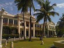
- Building and Garden — the Ermita Garden and Building on top of the Ermita Hill.
- Bridge — formerly the Gilbert Bridge, recently renamed Marcos Bridge.
- Airport — the Gabu Airport, one of the international airports of the country.
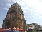
- Tower — the Sinking Tower, one of the oldest and strongest edifices built during the early Spanish Regime.
- Monument — the Tobacco Monopoly Monument, the only one of its kind in the entire country.
- Farmer plowing — symbol of the agricultural industry of the Ilocos Region.
Tourism
Tourism has become a major economic driver of Laoag City, paving the way for new commercial investments and infrastructure development. A recent surge in Chinese and Taiwanese tourists have been flocking to splurge in the city's profitable casino located inside the only 5-star hotel in northern Philippines: Fort Ilocandia Hotel and Resort. Other places of interest include a tour of heritage sites featuring Spanish colonial buildings, baroque churches, La Paz Sand Dunes, white-sand beach resorts of Pagudpud, and Marcos-era mansions.
The Laoag Cathedral was built in 1612 by Augustinian friars to replace a wooden chapel. It also serves as the seat or central church of the Roman Catholic Diocese of Laoag. Built with an Italian Renaissance, the church has an unusual two-storey façade, supported by two pairs of columns on each side of the arched entrance architecture design and at the top of the facade holds a recessed niche that showcases the image of the city's patron saint, William of Maleval.
The dramatic increase in tourist arrivals also prompted the establishment of a Chinese consulate to oversee the security of Chinese citizens living or visiting the city. A new immigration policy set to simplify entry of Chinese tourists into the country by issuing visitor visas in the airport after arrival is expected to entice more guests to come. To supplement the anticipated growth in tourist-related business activity, the government of Ilocos Norte has started construction on a multimillion-dollar convention center and hotel to supply the demand and diversify services. Laoag City has been named as one of the top tourist destinations in Region I and in the country.
Transportation

Laoag International Airport services flights to and from Guangzhou and Macau, as well as, domestic flights by Philippine Airlines. Foreign airlines offer direct charter flights to Laoag as part of travel packages with optional excursions to tourist sites outside of the city. Tourists can find travel agencies all over including ticket offices of several airlines in the airport terminal.
Several large bus companies serve Laoag City making connections to major and minor Philippines destinations. These transportation services are provided by GV Florida Transport, Maria de Leon Bus Lines, RCJ Lines, Partas, Farinas Transit Company. Laoag is 487 kilometres (303 mi) from Manila.
Education
As the provincial capital, Laoag is the center of social and economic activity with almost all major commercial and institutional establishments gravitating towards it. The importance of education in socializing its population is shared by both the local government and the private sector, which has invested heavily in the development of the academic infrastructure. The city is home to public and private schools offering elementary, secondary, and tertiary education programs. Current Philippine law requires free compulsory education to the general population from elementary to high school, as well as, subsidized tertiary education in state-ran institutions. Alternative private schools offering parallel programs to government schools are also found with additional programs to cater to students with various needs. These schools are an important component of the educational system and reflect the city's diversity as they include Chinese schools, Catholic schools, single-gender boarding schools, and military schools.
Most of the lower-level schools are government-owned and are divided into three districts, comprising a total of thirty-three primary and elementary schools. Seven private elementary schools are also present, however, most are sectarian and run by religious organizations. In addition, there are eight private and three public high schools, although the latter has significantly higher number of attendees. The Department of Education, Division of Laoag City is currently supervised by Ms. Aracelli C. Pastor.
In order to provide continuing education to sustain the economic momentum of the region, the government has established tertiary public learning institutions in the city: the College of Teacher Education (CTE) and the College of Industrial Technology (CIT) of the Mariano Marcos State University.
In addition, private colleges and universities are also found in the city, each with their own specialization. Private higher education institutions in the city include Northwestern University, Northern Christian College, and the Divine Word College of Laoag.
Also found in Laoag are four private vocational schools: STI Laoag, the Overseas Technical Institute (electronics and car maintenance), the Lazo Fashion School (cosmetology), and the Bel Arte School of Fine Arts.
Media
TV stations
- TV5 Laoag Channel 2
- GMA Laoag Channel 5
- ABS-CBN Laoag Channel 7
- ABS-CBN Sports and Action Laoag Channel 23
- GMA News TV Laoag Channel 27
Radio
AM stations:
- DZVR 711 kHz (Bombo Radyo Philippines)
- DZJC 747 kHz (Pacific Broadcasting Systems)
- DWAR 819 kHz (Sonshine Media Network International)
- DZEA 909 kHz (Catholic Media Network)
- DWFB 954 kHz (Philippine Broadcasting Service)
- DZMT 990 kHz (Philippine Broadcasting Corporation)
- DWRC 1269 kHz (Radio GMA)
FM stations:
- DWIL 90.7 Love Radio (Philippine Broadcasting Corporation)
- DWNA 93.1 Hot FM (Manila Broadcasting Company)
- DWEL MOR 95.5 For Life! (ABS-CBN Corporation)
- DWSN 97.9 Mom's Radio (Southern Broadcasting Network)
- DWHP 99.5 iFM (Radio Mindanao Network)
News Programs
- TV Patrol North Luzon (ABS-CBN Baguio)
- Balitang Amianan (GMA Dagupan)
Sister city
References
- "City". Quezon City, Philippines: Department of the Interior and Local Government. Retrieved 30 May 2013.
- "Province: Ilocos Norte". PSGC Interactive. Quezon City, Philippines: Philippine Statistics Authority. Retrieved 12 November 2016.
- Census of Population (2015). "Region I (Ilocos Region)". Total Population by Province, City, Municipality and Barangay. PSA. Retrieved 20 June 2016.
- "PSA releases the 2015 Municipal and City Level Poverty Estimates". Quezon City, Philippines. Retrieved 1 January 2020.
- http://inorte.org/?page_id=2948
- "History". City Government of Laoag. Archived from the original on 23 July 2016. Retrieved 31 August 2016.
- "Geographical Location". City Government of Laoag. Archived from the original on 11 October 2016. Retrieved 31 August 2016.
- "2010 Census of Population and Housing: Total Population by Province, City, Municipality and Barangay:as of May 1, 2010" (PDF). Philippine Statistics Authority. Archived from the original (PDF) on 23 October 2014. Retrieved 18 October 2014.
- "Laoag, Ilocos Norte Climatological Normal Values". Philippine Atmospheric, Geophysical and Astronomical Services Administration. Archived from the original on 13 October 2018. Retrieved 13 October 2018.
- "Laoag, Ilocos Norte Climatological Extremes". Philippine Atmospheric, Geophysical and Astronomical Services Administration. Archived from the original on 13 October 2018. Retrieved 13 October 2018.
- "Station 98223 Laoag". Global station data 1961–1990—Sunshine Duration. Deutscher Wetterdienst. Archived from the original on 17 October 2017. Retrieved 13 October 2018.
- "Station ID for Laoag is 98223. Use this station ID to locate the sunshine duration". Archived from the original on 2017-10-17. Retrieved 2018-10-13.
- Census of Population and Housing (2010). "Region I (Ilocos Region)". Total Population by Province, City, Municipality and Barangay. NSO. Retrieved 29 June 2016.
- Censuses of Population (1903–2007). "Region I (Ilocos Region)". Table 1. Population Enumerated in Various Censuses by Province/Highly Urbanized City: 1903 to 2007. NSO.
- "Province of Ilocos Norte". Municipality Population Data. Local Water Utilities Administration Research Division. Retrieved 17 December 2016.
- "Bangui windmills".
- "Official City/Municipal 2013 Election Results". Intramuros, Manila, Philippines: Commission on Elections (COMELEC). 11 September 2013. Retrieved 26 September 2013.
Bibliography
- Dela Torre, Visitacion (2006). The Ilocos Heritage. Makati City: Tower Book House. ISBN 978-971-91030-9-7.CS1 maint: ref=harv (link)
- Historical Markers: Regions I-IV and CAR (in Filipino). Manila: National Historical Institute (Philippines). 1993. p. 88. ISBN 9715380611.
External links
| Wikimedia Commons has media related to Laoag City. |
| Wikivoyage has a travel guide for Laoag. |
- Laoag Profile at PhilAtlas.com
- Official Site
- Philippine Standard Geographic Code
- Philippine Census Information
- Local Governance Performance Management System
Places adjacent to Laoag | ||||||||||
|---|---|---|---|---|---|---|---|---|---|---|
| ||||||||||
Laoag (capital) | |
| Municipalities | |
| Component cities | |
| Barangays | |

| Authority control |
|
|---|