Pagudpud
Pagudpud, officially the Municipality of Pagudpud, is a 4th class municipality in the province of Ilocos Norte, Philippines. According to the 2015 census, it has a population of 23,770 people.[3]
Pagudpud | |
|---|---|
| Municipality of Pagudpud | |
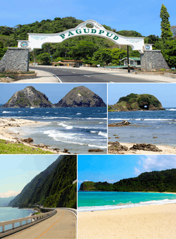 From top to bottom right: Welcome arch passing through Pan-Philippine Highway, Dos Hermanos islands, Bantay Abot cave, Patapat Viaduct overlooking Pasaleng Bay, and Blue Lagoon | |
 Seal | |
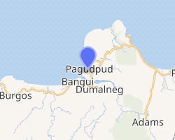
 Map of Ilocos Norte with Pagudpud highlighted | |
| |
.svg.png) Pagudpud Location within the Philippines | |
| Coordinates: 18°33′30″N 120°47′05″E | |
| Country | |
| Region | Ilocos Region (Region I) |
| Province | Ilocos Norte |
| District | 1st District |
| Founded | July 5, 1954 |
| Barangays | 16 (see Barangays) |
| Government | |
| • Type | Sangguniang Bayan |
| • Mayor | Rafael Ralph L. Benemerito II |
| • Vice Mayor | Matilde H. Sales |
| • Congressman | Ria Christina G. Fariñas |
| • Electorate | 16,668 voters (2019) |
| Area | |
| • Total | 194.90 km2 (75.25 sq mi) |
| Elevation | 10.8 m (35.4 ft) |
| Population (2015 census)[3] | |
| • Total | 23,770 |
| • Density | 120/km2 (320/sq mi) |
| • Households | 5,427 |
| Economy | |
| • Income class | 4th municipal income class |
| • Poverty incidence | 9.48% (2015)[4] |
| • Revenue (₱) | 135,416,657.97 (2016) |
| Time zone | UTC+8 (PST) |
| ZIP code | 2919 |
| PSGC | |
| IDD : area code | +63 (0)77 |
| Climate type | tropical monsoon climate |
| Native languages | Ilocano Tagalog |
| Website | www |
It is the northernmost settlement on Luzon Island and a popular tourist destination because of its resorts and beaches. In addition to tourism, people also make their living through farming, fishing and subsistence retailing. Recently, many windmills erected in Barangay Caparispisan.
Pagudpud was made a municipality on 5 July 1954 through the leadership of Constante Benemerito. It was Rafael "Totoy" Benemerito, son of Constante, who spearheaded the establishment of the first municipal hall, municipal health center, public plaza, and public market. It had previously been a part of the neighboring town of Bangui.
Geography
Pagudpud lies 74 kilometres (46 mi) north of Laoag City, the provincial capital, and 561 kilometres (349 mi) north of Manila. Maira-ira Beach is the northernmost tip of Luzon Island, located at 18°39′4.44″N 120°50′46.68″E on the Luzon Strait.
The town's topography includes mountains, hills, valleys and flat coastal land.
Barangays
Pagudpud is politically divided in 16 barangays:
Urban
| Names of Barangay | BarangayNo. |
|---|---|
| Uno 1 | 1 |
| Poblacion 2 | 2 |
Rural
| Names of Barangay | BarangayNo. |
|---|---|
| Saud | 12 |
| Caparispisan | 16 |
| Subec | 6 |
| Aggasi | |
| Saguigui | |
| Baduang | 7 |
| Burayoc | 3 |
| Dampig | |
| Tarrag | |
| Ligaya | 14 |
| Caunayan | 5 |
| Balaoi | |
| Pancian | |
| Pasaleng | 4 |
Climate
| Climate data for Pagudpud, Ilocos Norte | |||||||||||||
|---|---|---|---|---|---|---|---|---|---|---|---|---|---|
| Month | Jan | Feb | Mar | Apr | May | Jun | Jul | Aug | Sep | Oct | Nov | Dec | Year |
| Average high °C (°F) | 31 (88) |
32 (90) |
33 (91) |
34 (93) |
34 (93) |
34 (93) |
33 (91) |
32 (90) |
32 (90) |
33 (91) |
32 (90) |
31 (88) |
33 (91) |
| Average low °C (°F) | 19 (66) |
20 (68) |
21 (70) |
23 (73) |
24 (75) |
24 (75) |
24 (75) |
24 (75) |
24 (75) |
23 (73) |
22 (72) |
21 (70) |
22 (72) |
| Average rainfall mm (inches) | 6.2 (0.24) |
11.7 (0.46) |
10.1 (0.40) |
14 (0.6) |
192.7 (7.59) |
258.9 (10.19) |
470.9 (18.54) |
475.9 (18.74) |
405.7 (15.97) |
92.5 (3.64) |
44.8 (1.76) |
2 (0.1) |
1,985.4 (78.23) |
| Average rainy days | 3 | 2 | 2 | 2 | 12 | 15 | 20 | 20 | 17 | 10 | 6 | 3 | 112 |
| Source: World Weather Online[5] | |||||||||||||
Demographics
| Population census of Pagudpud | |||||||||||||||||||||||||||||||||||||
|---|---|---|---|---|---|---|---|---|---|---|---|---|---|---|---|---|---|---|---|---|---|---|---|---|---|---|---|---|---|---|---|---|---|---|---|---|---|
|
| ||||||||||||||||||||||||||||||||||||
| Source: Philippine Statistics Authority[3][6][7][8] | |||||||||||||||||||||||||||||||||||||
In the 2015 census, the population of Pagudpud was 23,770 people,[3] with a density of 120 inhabitants per square kilometre or 310 inhabitants per square mile.
Religion
Roman Catholicism is the major religion in Pagudpud. Yet, there's also increasing numbers of members of other Christian Denominations such as Jehovah's Witnesses (with two congregations) and Iglesia ni Cristo. Islam, brought by Muslim immigrants, is also practiced in Pagudpud.
Local government
These are the current officials of Pagudpud:[9]
- Mayor: Rafael Ralph Benemerito II
- Vice Mayor: Matilde Sales
- Councilors:
- Ferdinand R. Garvida
- Efren B. Cimatu
- Emilen G. Sales
- Rajan L. Benemerito
- Reynald Garvida
- Joseph Caliw Caliw
- Dane Sales
- Wilfredo Ubasa
Government seal
Blue, Red, Yellow, and White, reflection of the colors of the Philippines 1954, the year Pagudpud was founded
Coconut Tree and Ricefield, represents as farming as one of the economic resources of the town, with coconut, palay and vegetables as its major products
Waterfall, represents Mabogobog falls, which is the source of a Mini Hydro Power Plant.
Mountain, Tree and Logs, represents the forestry resources of the town
Fish and Shrimps, represents its marine resoureces
Shell with Pearl, symbolizes the tourism potential of the town which is famous for its white beaches
North Star, stands for the location of the town of Pagudpud, which is in the northern tip of the Province.
Transportation
By land, Pagudpud is approximately a 90-minute bus ride from Laoag City. Several bus lines serve the Manila-Laoag route, namely Partas, Florida, Farinas, and Maria de Leon among others. Some bus lines serve also the Pan-Philippine highway, the Asian Highway ends here for Taiwan the 27th Nation, dropping by in Pagudpud, namely Chona Patrick, GMW, St. Joseph, Gabriel, and the Pan-Philippine highway route buses of Maria de Leon and Florida.
Gallery
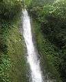 Kabigan Falls in Pagudpud
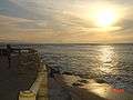 Sunset at Burayoc Point at the juncture of Saud Beach near Pagudpud Rinnovati.
 Saud Beach near Polaris Beach House
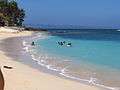 Saud Beach near Apo Idon resort. The Northwind Power windmills in neighboring Bangui can be seen in the distance.
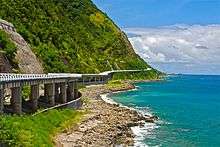 The Patapat Viaduct
 Saud Beach
See also
References
- "Municipality". Quezon City, Philippines: Department of the Interior and Local Government. Retrieved 31 May 2013.
- "Province: Ilocos Norte". PSGC Interactive. Quezon City, Philippines: Philippine Statistics Authority. Retrieved 12 November 2016.
- Census of Population (2015). "Region I (Ilocos Region)". Total Population by Province, City, Municipality and Barangay. PSA. Retrieved 20 June 2016.
- "PSA releases the 2015 Municipal and City Level Poverty Estimates". Quezon City, Philippines. Retrieved 1 January 2020.
- "Pagudpud, Philippines: Average Temperatures and Rainfall". World Weather Online. Retrieved 15 September 2014.
- Census of Population and Housing (2010). "Region I (Ilocos Region)". Total Population by Province, City, Municipality and Barangay. NSO. Retrieved 29 June 2016.
- Censuses of Population (1903–2007). "Region I (Ilocos Region)". Table 1. Population Enumerated in Various Censuses by Province/Highly Urbanized City: 1903 to 2007. NSO.
- "Province of Ilocos Norte". Municipality Population Data. Local Water Utilities Administration Research Division. Retrieved 17 December 2016.
- "Official City/Municipal 2013 Election Results". Intramuros, Manila, Philippines: Commission on Elections (COMELEC). 11 September 2013. Retrieved 3 October 2013.
External links
| Wikimedia Commons has media related to Pagudpud, Ilocos Norte. |
| Wikivoyage has a travel guide for Pagudpud. |
- Pagudpud Profile at PhilAtlas.com
- Municipality of Pagudpud
- Article about Pagudpud and Saud Beach with plenty of Photographs
- Philippine Standard Geographic Code
- Philippine Census Information
- Local Governance Performance Management System
Places adjacent to Pagudpud | ||||||||||
|---|---|---|---|---|---|---|---|---|---|---|
| ||||||||||