Carasi
Carasi, officially the Municipality of Carasi, is a 5th class municipality in the province of Ilocos Norte, Philippines. According to the 2015 census, it has a population of 1,567 people.[3]
Carasi | |
|---|---|
| Municipality of Carasi | |
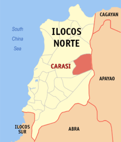 Map of Ilocos Norte with Carasi highlighted | |
OpenStreetMap 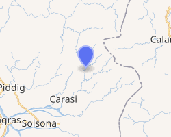
| |
.svg.png) Carasi Location within the Philippines | |
| Coordinates: 18°12′N 120°52′E | |
| Country | |
| Region | Ilocos Region (Region I) |
| Province | Ilocos Norte |
| District | 1st District |
| Barangays | 3 (see Barangays) |
| Government | |
| • Type | Sangguniang Bayan |
| • Mayor | Rene V. Gaspar |
| • Vice Mayor | Wilson T. Bulil-lit |
| • Congressman | Ria Christina G. Fariñas |
| • Electorate | 1,406 voters (2019) |
| Area | |
| • Total | 82.97 km2 (32.03 sq mi) |
| Elevation | 128.2 m (420.6 ft) |
| Population (2015 census)[3] | |
| • Total | 1,567 |
| • Density | 19/km2 (49/sq mi) |
| • Households | 304 |
| Economy | |
| • Income class | 5th municipal income class |
| • Poverty incidence | 20.34% (2015)[4] |
| • Revenue (₱) | 49,570,744.26 (2016) |
| Time zone | UTC+8 (PST) |
| ZIP code | 2911 |
| PSGC | |
| IDD : area code | +63 (0)77 |
| Climate type | tropical monsoon climate |
| Native languages | Ilocano Tagalog |
| Website | www |
Geography
Carasi is a land-locked town situated in the eastern border of Ilocos Norte. It has an area of 157.48 km2. Vintar is situated in the north of Carasi, Calanasan in the east, Nueva Era in the south and Piddig in the west. It is in the foot of the Cordillera Mountains.
Barangays
Carasi is politically subdivided into 3 barangays. [2]
- Angset
- Barbaqueso (Poblacion)
- Virbira
Climate
| Climate data for Carasi, Ilocos Norte | |||||||||||||
|---|---|---|---|---|---|---|---|---|---|---|---|---|---|
| Month | Jan | Feb | Mar | Apr | May | Jun | Jul | Aug | Sep | Oct | Nov | Dec | Year |
| Average high °C (°F) | 24 (75) |
25 (77) |
27 (81) |
29 (84) |
29 (84) |
28 (82) |
27 (81) |
27 (81) |
27 (81) |
26 (79) |
25 (77) |
24 (75) |
27 (80) |
| Average low °C (°F) | 17 (63) |
17 (63) |
19 (66) |
20 (68) |
22 (72) |
23 (73) |
22 (72) |
22 (72) |
22 (72) |
21 (70) |
20 (68) |
18 (64) |
20 (69) |
| Average precipitation mm (inches) | 55 (2.2) |
41 (1.6) |
37 (1.5) |
41 (1.6) |
184 (7.2) |
215 (8.5) |
261 (10.3) |
256 (10.1) |
245 (9.6) |
216 (8.5) |
142 (5.6) |
129 (5.1) |
1,822 (71.8) |
| Average rainy days | 14.1 | 11.1 | 11.8 | 12.5 | 21.8 | 25.2 | 25.5 | 24.9 | 23.8 | 18.2 | 16.4 | 17.0 | 222.3 |
| Source: Meteoblue (Use with caution: this is modeled/calculated data, not measured locally.) [5] | |||||||||||||
Demographics
| Population census of Carasi | ||
|---|---|---|
| Year | Pop. | ±% p.a. |
| 1939 | 261 | — |
| 1948 | 231 | −1.35% |
| 1960 | 222 | −0.33% |
| 1970 | 340 | +4.35% |
| 1975 | 374 | +1.93% |
| 1980 | 421 | +2.39% |
| 1990 | 632 | +4.15% |
| 1995 | 750 | +3.26% |
| 2000 | 1,154 | +9.68% |
| 2007 | 1,435 | +3.05% |
| 2010 | 1,473 | +0.96% |
| 2015 | 1,567 | +1.18% |
| Source: Philippine Statistics Authority[3][6][7][8] | ||
In the 2015 census, the population of Carasi was 1,567 people,[3] with a density of 19 inhabitants per square kilometre or 49 inhabitants per square mile.
Local government
As of the term 2013–2016, these are the elected officials of Carasi:[9]
- Mayor: Rene V. Gaspar
- Vice Mayor: Villamor G. Julian
- Councilors:
- Nestor S. Julian
- Eric P. Advincula
- Domingo R. Pumaras
- Joepat P. Aguibay
- Edgar S. Sueb
- Rhelly S. Rivac
- Clemente P. Abal
- Rey Transfiguracion
Government seal
Shield, denotes that Carasi is within the Province of Ilocos Norte
Deer, represents hunting as means of livelihood of the townspeople
Pine Tree, stands for the forest products that abound in the town
Center Design, signifies defense and protection (shield); hardwork (bolo); and patriotism and bravery (spear).
References
- "Municipality". Quezon City, Philippines: Department of the Interior and Local Government. Retrieved 31 May 2013.
- "Province: Ilocos Norte". PSGC Interactive. Quezon City, Philippines: Philippine Statistics Authority. Retrieved 12 November 2016.
- Census of Population (2015). "Region I (Ilocos Region)". Total Population by Province, City, Municipality and Barangay. PSA. Retrieved 20 June 2016.
- "PSA releases the 2015 Municipal and City Level Poverty Estimates". Quezon City, Philippines. Retrieved 1 January 2020.
- "Carasi: Average Temperatures and Rainfall". Meteoblue. Retrieved 4 March 2020.
- Census of Population and Housing (2010). "Region I (Ilocos Region)". Total Population by Province, City, Municipality and Barangay. NSO. Retrieved 29 June 2016.
- Censuses of Population (1903–2007). "Region I (Ilocos Region)". Table 1. Population Enumerated in Various Censuses by Province/Highly Urbanized City: 1903 to 2007. NSO.
- "Province of Ilocos Norte". Municipality Population Data. Local Water Utilities Administration Research Division. Retrieved 17 December 2016.
- "Official City/Municipal 2013 Election Results". Intramuros, Manila, Philippines: Commission on Elections (COMELEC). 11 September 2013. Retrieved 3 October 2013.
External links
- Carasi Profile at PhilAtlas.com
- Pasyalan Ilocos Norte
- Philippine Standard Geographic Code
- Philippine Census Information
- Local Governance Performance Management System
Places adjacent to Carasi | ||||||||||
|---|---|---|---|---|---|---|---|---|---|---|
| ||||||||||
Laoag (capital) | |
| Municipalities | |
| Component cities | |
| Barangays | |