Dapitan
Dapitan, officially the City of Dapitan (Cebuano: Dakbayan sa Dapitan; Subanon: Gembagel G'benwa Dapitan/Bagbenwa Dapitan), is a 3rd class city in the province of Zamboanga del Norte, Philippines. According to the 2015 census, it has a population of 82,418 people.[3]
Dapitan | |
|---|---|
| City of Dapitan | |
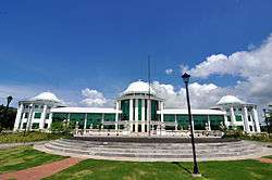 City Hall | |
 Seal | |
Nicknames:
| |
| Motto(s): Abante Kaayo Dapitanon (Forward More Dapitanon) | |
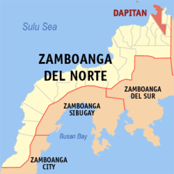 Map of Zamboanga del Norte with Dapitan highlighted | |
OpenStreetMap 
| |
.svg.png) Dapitan Location within the Philippines | |
| Coordinates: 8°39′18″N 123°25′27″E | |
| Country | |
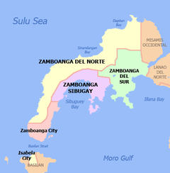
| Region | Zamboanga Peninsula (Region IX) |
| Province | Zamboanga del Norte |
| District | 1st District |
| Founded | 1629 |
| Cityhood | June 22, 1963 |
| Barangays | 50 (see Barangays) |
| Government | |
| • Type | Sangguniang Panlungsod |
| • Mayor | Rosalina G. Jalosjos |
| • Vice Mayor | Jimmy Patrick Israel B. Chan |
| • Congressman | Romeo M. Jalosjos Jr. |
| • Electorate | 57,434 voters (2019) |
| Area | |
| • Total | 390.53 km2 (150.78 sq mi) |
| Elevation | 7.3 m (24.0 ft) |
| Population (2015 census)[3] | |
| • Total | 82,418 |
| • Density | 210/km2 (550/sq mi) |
| • Households | 17,953 |
| Demonym(s) | Dapitanon |
| Economy | |
| • Income class | 3rd city income class |
| • Poverty incidence | 36.14% (2015)[4] |
| • Revenue (₱) | 540,006,232.83 (2016) |
| Time zone | UTC+8 (PST) |
| ZIP code | 7101 |
| PSGC | |
| IDD : area code | +63 (0)65 |
| Climate type | tropical climate |
| Native languages | Subanon language Cebuano Chavacano Tagalog |
| Website | www |
It is historically significant as the place where José Rizal was exiled by the Spaniards for his revolutionary activities. He is considered a national hero, and this is known as the "Shrine City in the Philippines." It is also often considered the capital of Mindanao Island. The city is also home to Gloria's Fantasyland, the first amusement park in Mindanao.
History
Cityhood
On June 22, 1963, President Diosdado Macapagal signed R.A. 3811 which converted Dapitan into a chartered city. It is officially renowned as the “Shrine City of the Philippines.”
The earliest settlers of Dapitan were the Subanens, a nomadic tribe of Indonesian stock known to have settled and lived along the banks of the river or “suba” out of which their present-day tribal identity originated.
Climate
| Climate data for Dapitan City, Zamboanga del Norte | |||||||||||||
|---|---|---|---|---|---|---|---|---|---|---|---|---|---|
| Month | Jan | Feb | Mar | Apr | May | Jun | Jul | Aug | Sep | Oct | Nov | Dec | Year |
| Average high °C (°F) | 29 (84) |
29 (84) |
30 (86) |
31 (88) |
30 (86) |
30 (86) |
29 (84) |
30 (86) |
30 (86) |
29 (84) |
29 (84) |
29 (84) |
30 (85) |
| Average low °C (°F) | 23 (73) |
23 (73) |
23 (73) |
24 (75) |
25 (77) |
25 (77) |
24 (75) |
24 (75) |
24 (75) |
24 (75) |
24 (75) |
24 (75) |
24 (75) |
| Average precipitation mm (inches) | 104 (4.1) |
76 (3.0) |
92 (3.6) |
97 (3.8) |
199 (7.8) |
238 (9.4) |
195 (7.7) |
193 (7.6) |
178 (7.0) |
212 (8.3) |
171 (6.7) |
110 (4.3) |
1,865 (73.3) |
| Average rainy days | 14.7 | 12.5 | 15.8 | 17.5 | 27.6 | 28.5 | 29.0 | 27.5 | 26.9 | 27.9 | 23.5 | 18.2 | 269.6 |
| Source: Meteoblue (modeled/calculated data, not measured locally) [5] | |||||||||||||
Barangays
Dapitan City is politically subdivided into 50 barangays, of which 8 barangays are urban, 27 are interior, 13 are coastal, and 2 are island barangays.[6] In 1955, the sitios of Sipalok, Barcelona, and Potungan were converted into barrios.[7]
- Aliguay (island barangay)
- Antipolo (interior)
- Aseniero (interior)
- Ba-ao (interior)
- Bagting (urban)
- Banbanan (coastal)
- Banonong (urban)
- Barcelona (interior)
- Baylimango (coastal)
- Burgos (interior)
- Canlucani (coastal)
- Carang (coastal)
- Cawa-cawa (urban)
- Dampalan (interior)
- Daro (interior)
- Dawo (urban)
- Diwa-an (interior)
- Guimputlan (coastal)
- Hilltop (interior)
- Ilaya (interior)
- Kauswagan (interior)
- Larayan (interior)
- Linabo (urban)
- Liyang (interior)
- Maria Cristina (interior)
- Maria Uray (interior)
- Masidlakon (interior)
- Napo (coastal)
- Opao (interior)
- Oro (coastal)
- Owaon (interior)
- Oyan (interior)
- Polo (coastal)
- Potol (urban)
- Potungan (interior)
- San Francisco (interior)
- San Nicolas (interior)
- San Pedro (coastal)
- San Vicente (coastal)
- Santa Cruz (urban)
- Santo Niño (interior)
- Sicayab Bocana (coastal)
- Sigayan (interior)
- Silinog (island barangay)
- Sinonoc (interior)
- Sulangon (interior)
- Tag-olo (coastal)
- Taguilon (coastal)
- Talisay (Urban)
- Tamion (interior)
Taguilon

Taguilon is home to the Dakak Park and Beach Resort. It is a producer of coconut and agar (based on sea weed) as well as a fishing port. The pier in Taguilon is a secondary/alternate port to the main passenger/cargo port in Dapitan City. Additionally, during severe storms at sea, ferries and other ships find shelter in the Taguilon cove. One can find the mount Lalab overlooking the islets of Silinog and part of Balyangaw.
Talisay
Talisay is a seaside barangay where José Rizal spent four years in exile. A park and shrine honoring the Philippine national hero can be found in the José Rizal Memorial Protected Landscape, a protected area declared in 2000, located in the old Rizal farm site in the barangay.
Demographics
| Population census of Dapitan | |||||||||||||||||||||||||||||||||||||||||||||||||
|---|---|---|---|---|---|---|---|---|---|---|---|---|---|---|---|---|---|---|---|---|---|---|---|---|---|---|---|---|---|---|---|---|---|---|---|---|---|---|---|---|---|---|---|---|---|---|---|---|---|
|
| ||||||||||||||||||||||||||||||||||||||||||||||||
| Source: Philippine Statistics Authority[3][8][9][10] | |||||||||||||||||||||||||||||||||||||||||||||||||
Places of interest
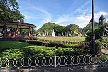
- Liwasan ng Dapitan (Dapitan City Plaza)
- Dapitan City Plaza ("Liwasan ng Dapitan"), also known as the City Square, was beautified and developed by Dr. José Rizal during his exile. With the assistance of the Spanish Politico-Military Governor of Dapitan, Gov. Ricardo Carnicero, Rizal made the City Square comparable to those he saw in Europe.[11] It has an area of one hectare, more or less.

- Punto del Desembarco de Rizal
- Rizal disembarked in Punto del Desembarco de Rizal (Rizal's Point of Disembarking). A 20-foot cross also stands in the place to symbolize the propagation of Christianity in the locality of Dapitan.
_12.JPG)
- Rizal Park and Shrine
- Rizal Park and Shrine is a major historical landmark in Dapitan. In August 1892, Rizal, together with Governor Carnicero and Francisco Equilor, a Spaniard living in Dipolog, won a lottery bet which financially enabled Dr. Rizal to buy a 10-hectare piece of land from Lucia Pagbangon. Rizal moved to the area in which the shrine currently stands in March 1893. Later on, his mother, Doña Teodora Alonso Realonda, his sisters, and some relatives from Calamba, Laguna, came and lived with him in Barangay Talisay (which is where the shrine is located) until 1896. Rizal Shrine was declared a national shrine through Presidential Decree No. 105 issued by then-President Ferdinand Marcos on January 24, 1973.
- Casa Real
- Rizal stayed in Casa Real with Governor Carnicero from his arrival until he moved to the present-day location of Rizal Shrine in Barangay Talisay in March 1893. The appearance of Casa Real is similar to that of the old city hall, with bamboo on each side and the upper portion made up of wood. A replica of Casa Real will soon rise near its marker.
- St. James the Greater Church
- This church was built in 1871 in honor of St. James the Greater, Dapitan's patron saint. The design of the interior walls is more or less one meter thick and still original except for the furnishing. The altar and the interior hane undergone several renovations. Inside is a historical spot where Rizal stood while hearing Mass every Sunday. At the mezzanine is the priceless heritage organ that bears the year wherein it was made – 1827 – at the choir loft. It was brought to Dapitan by the Agustinian Recollect fathers. A German-made instrument with European pipes, it is a manual pipe organ.
- Cotta de Dapitan
- Established in 1761, the fort was made to monitor the waters of northern Zamboanga. The fort was made on top of the sacred Ilihan Hill. Currently, the fort is in dire need of conservation.
Festivals
Dapitan City has launched a diversified fiesta celebration of its Patron St. James or Señor Santiago for the locals through a three-in-one affair, combining religious, cultural and sports events in its Kinabayo Festival 2009.
The Kinabayo Festival kicks off July 16 and culminates on July 31 with various events taking place within the Shrine City of the Philippines.
Transportation
Sea

Dapitan is served by the Port of Pulauan in barangay San Vicente (albeit ferry schedules often list the destination as Port of Dipolog, a neighboring city). There are daily ferries from/to Dumaguete and from/to Cebu City.
Air
Dapitan is catered by Dipolog City Airport through Phil. Air, Cebu Pacific and 2Go Airline. From Dipolog take a shuttle bus to Dapitan which is 20–30 minutes ride, that's 12 kilometers from the airport to the City proper of Dapitan.
Notable people
- José Rizal (b. 1861 - d. 1896) - national hero
- Martha Cecilia (b. 1953 - d. 2014) - Filipino writer of Tagalog romance pocketbook novels
- Very Rev. Joel S. Montederamos (b. 1972) - Vicar General of the Roman Catholic Diocese of Dipolog (since 2014)
- Gazini Ganados (b. 1995) - Filipino fashion model and beauty pageant titleholder who became Binibining Pilipinas 2019 Universe and part of Top 20 of Miss Universe 2019.
- Theodore Boborol (b. 1979) - A renowned film and television director in the Philippines.
International relations
Twin towns — Sister cities
Dapitan is twinned with:


References
- "City". Quezon City, Philippines: Department of the Interior and Local Government. Retrieved 30 May 2013.
- "Province: Zamboanga del Norte". PSGC Interactive. Quezon City, Philippines: Philippine Statistics Authority. Retrieved 12 November 2016.
- Census of Population (2015). "Region IX (Zamboanga Peninsula)". Total Population by Province, City, Municipality and Barangay. PSA. Retrieved 20 June 2016.
- "PSA releases the 2015 Municipal and City Level Poverty Estimates". Quezon City, Philippines. Retrieved 12 October 2019.
- "Dapitan: Average Temperatures and Rainfall". Meteoblue. Retrieved 30 April 2020.
- "Barangays". Dapitan City Official Website. Retrieved 7 October 2019.
- "An Act Converting into Barrios Certain Sitios in the Province of Zamboanga Del Norte". LawPH.com. Archived from the original on 2012-07-14. Retrieved 2011-04-11.
- Census of Population and Housing (2010). "Region IX (Zamboanga Peninsula)". Total Population by Province, City, Municipality and Barangay. NSO. Retrieved 29 June 2016.
- Censuses of Population (1903–2007). "Region IX (Zamboanga Peninsula)". Table 1. Population Enumerated in Various Censuses by Province/Highly Urbanized City: 1903 to 2007. NSO.
- "Province of Zamboanga del Norte". Municipality Population Data. Local Water Utilities Administration Research Division. Retrieved 17 December 2016.
- "Liwasan ng Dapitan: Dapitan City Plaza". June 18, 2010. Retrieved September 4, 2014.
External links
| Wikivoyage has a travel guide for Dapitan. |
| Wikimedia Commons has media related to Dapitan. |
Places adjacent to Dapitan | |
|---|---|