Lapu-Lapu, Philippines
Lapu-Lapu, officially the City of Lapu-Lapu (Cebuano: Dakbayan sa Lapu-Lapu; Tagalog: Lungsod ng Lapu-Lapu), is a 1st class highly urbanized city in the region of Central Visayas, Philippines. According to the 2015 census, it has a population of 408,112 people.[3]
Lapu-Lapu | |
|---|---|
| City of Lapu-Lapu | |
 Aerial view over MEPZ–II | |
 Seal | |
| Nickname(s): Historic Resort City | |
 Map of Central Visayas with Lapu-Lapu highlighted | |

| |
.svg.png) Lapu-Lapu Location within the Philippines | |
| Coordinates: 10°18′54″N 123°58′34″E | |
| Country | |
| Region | Central Visayas (Region VII) |
| Province | Cebu (geographically only) |
| District | Lone district of Lapu‑Lapu |
| 1730 17 June 1961 22 October 2009 |
| Named for | Lapu-Lapu |
| Barangays | 30 (see Barangays) |
| Government | |
| • Type | Sangguniang Panlungsod |
| • Mayor | Junard Q. Chan |
| • Vice Mayor | Celedonio B. Sitoy |
| • Congresswoman | Paz C. Radaza |
| • Electorate | 214,117 voters (2019) |
| Area | |
| • Total | 58.10 km2 (22.43 sq mi) |
| Elevation | 5.4 m (17.7 ft) |
| Population (2015 census)[3] | |
| • Total | 408,112 |
| • Density | 7,000/km2 (18,000/sq mi) |
| • Households | 92,557 |
| Demonym(s) | Oponganon[4] |
| Economy | |
| • Income class | 1st city income class |
| • Poverty incidence | 16.68% (2015)[5] |
| • Revenue (₱) | 1,709,494,781.42 (2016) |
| Time zone | UTC+8 (Philippine Standard Time (PST)) |
| ZIP code | 6015 |
| PSGC | |
| IDD : area code | +63 (0)32 |
| Climate type | tropical climate |
| Native languages | Cebuano Tagalog |
| Website | www |
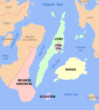
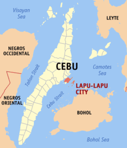
Formerly known as Opon, the city was renamed to its present name in 1961. It is one of the cities that make up Metro Cebu in the Philippines. It is geographically located in the province of Cebu, administratively independent from the province, but grouped under Cebu by the Philippine Statistics Authority (PSA).
Lapu-Lapu is bounded on the north by the main island of Cebu, to the west by Cebu City and Mactan Channel, on the east by the Camotes Sea, and on the south by the town of Cordova.
The city occupies Mactan Island, a few kilometers off the main island of Cebu. It also has some of the barangays under its jurisdiction on the Olango Island Group. The city is linked to Mandaue on mainland Cebu by the Mactan-Mandaue Bridge and Marcelo Fernan Bridges. Mactan-Cebu International Airport, the second busiest airport in the Philippines, is located in Lapu-Lapu.
History
In the 16th century, Mactan Island was colonized by Spain. Augustinian friars founded the town of Opon in 1730, and it became a city in 1961. It was renamed after Datu Lapu-Lapu, the island's chieftain, who led the defeat against the Portuguese explorer Ferdinand Magellan in 1521 in the Battle of Mactan, commemorated at the Lapu-Lapu shrine in Punta Engaño, where Magellan led a landing party of 40 men to resupply who were set upon by 1,500 locals and slew their captain and a few other men.
The municipality of Opon was founded by the Augustinian missionaries in 1730. It was ceded to the Jesuits in 1737, and later restored to the Augustinians. When the Philippine Revolution spread to the Visayas in 1896, the people organized themselves into local revolutionary units.
During the Filipino-American War, a military government was established. The continued resistance of the people of Cebu prompted the American government to restore military control over the province on July 17, 1901. In 1905, Opon held its first municipal election, and Pascual dela Serna was elected town president.
Following the outbreak of World War II, the presence of bulk oil storage tanks in Opon made the town an object of Japanese raids a week after the outbreak of WWII in December 1941. The enemy aircraft succeeded in blowing up two of about fourteen oil storage tanks in Opon. A unit of the Kawaguchi Detachment of the Japanese Imperial Forces landed on the east coast of Cebu on April 10, 1942. Later, the resistance movement was organized by Colonel James M. Cushing, leader of the southern and central units, and Harry Fenton of the northern unit of the Cebu Resistance Movement.
During the Battle of the Visayas, Victor II operations of the American Division led by Major General William Arnold landed in Cebu on March 26, 1945, and subsequently liberated the province.
Congressman Manuel A. Zosa, the representative of the Sixth District of Cebu, sponsored the Bill converting the former municipality of Opon into the present day city of Lapu-Lapu. This was the Republic Act 3134,[6] known as the City Charter of Lapu-Lapu, which was signed on June 17, 1961 by Philippine President Carlos P. Garcia. Lapu-Lapu was inaugurated on December 31, 1961, with Mariano Dimataga, the last municipal mayor, as the first city mayor.[7]
As a fast-growing commercial city, some of its commercial and industrial firms are the General Milling Company, one of the largest in the country; the Cebu Shipyard and Engineering Works, pioneered by Dad Cleland; and the oil companies which resumed their operations after the war. Air transportation for the city is served by the Mactan International Airport.
Historically, the city includes the site of the Battle of Mactan. On August 1, 1973, by virtue of Presidential Decree No. 2060, President Ferdinand E. Marcos declared the site of the battle a national shrine; the preservation, restoration and/or reconstruction of which shall be under the supervision and control of the National Historical Commission in collaboration with the Department of Tourism. Mactan is also the birthplace of Leonila Dimataga-Garcia, wife of Carlos P. Garcia, the fourth President of the Republic. Leonila Dimataga-Garcia was a relative of three-term consecutive Lapu-Lapu Citys' late Mayor, Ernest Weigel Jr. wife, who was the richest mayor in Metro Cebu, with a net worth of P57.7 million in the early 2000s.
Barangays
Lapu-Lapu comprises 30 barangays:

| PSGC | Barangay | Population | ±% p.a. | Area | PD 2015 | |||||
|---|---|---|---|---|---|---|---|---|---|---|
| 2015[3] | 2010[8] | ha | acre | /km2 | /sq mi | |||||
| 072226001 | Agus | 3.9% | 15,767 | 8,185 | 13.30% | 211 | 521 | 7,500 | 19,000 | |
| 072226002 | Babag | 5.6% | 22,756 | 17,721 | 4.88% | 307 | 759 | 7,400 | 19,000 | |
| 072226003 | Bankal | 5.1% | 20,872 | 13,802 | 8.19% | 201 | 497 | 10,000 | 27,000 | |
| 072226004 | Baring | 0.8% | 3,353 | 3,014 | 2.05% | 91 | 225 | 3,700 | 9,500 | |
| 072226005 | Basak | 14.7% | 59,873 | 45,927 | 5.18% | 603 | 1,490 | 9,900 | 26,000 | |
| 072226006 | Buaya | 3.9% | 16,072 | 12,123 | 5.52% | 271 | 670 | 5,900 | 15,000 | |
| 072226007 | Calawisan | 2.8% | 11,454 | 8,433 | 6.00% | 957 | 2,365 | 1,200 | 3,100 | |
| 072226008 | Canjulao | 3.2% | 13,245 | 11,471 | 2.78% | 156 | 385 | 8,500 | 22,000 | |
| 072226011 | Caubian | 0.6% | 2,272 | 2,028 | 2.19% | |||||
| 072226009 | Caw‑oy | 0.5% | 1,837 | 1,629 | 2.31% | 42 | 104 | 4,400 | 11,000 | |
| 072226010 | Cawhagan | 0.2% | 638 | 559 | 2.55% | |||||
| 072226012 | Gun‑ob | 7.6% | 31,219 | 34,662 | −1.97% | |||||
| 072226013 | Ibo | 2.0% | 8,126 | 7,055 | 2.73% | |||||
| 072226014 | Looc | 3.9% | 16,016 | 14,073 | 2.49% | |||||
| 072226015 | Mactan | 8.2% | 33,465 | 29,262 | 2.59% | |||||
| 072226016 | Maribago | 4.1% | 16,591 | 12,064 | 6.25% | |||||
| 072226017 | Marigondon | 4.8% | 19,713 | 17,542 | 2.25% | |||||
| 072226018 | Pajac | 4.3% | 17,402 | 16,084 | 1.51% | |||||
| 072226019 | Pajo | 5.1% | 20,999 | 23,107 | −1.80% | |||||
| 072226020 | Pangan‑an | 0.5% | 2,070 | 1,767 | 3.06% | |||||
| 072226021 | Poblacion[lower-alpha 1] | 1.4% | 5,581 | 8,243 | −7.16% | |||||
| 072226022 | Punta Engaño | 2.1% | 8,753 | 7,106 | 4.05% | |||||
| 072226024 | Pusok | 7.1% | 28,810 | 26,568 | 1.55% | |||||
| 072226025 | Sabang | 1.5% | 6,091 | 5,603 | 1.60% | |||||
| 072226031 | San Vicente | 0.9% | 3,854 | 3,413 | 2.34% | |||||
| 072226026 | Santa Rosa | 1.1% | 4,302 | 3,934 | 1.72% | |||||
| 072226027 | Subabasbas | 1.5% | 6,288 | 5,457 | 2.74% | |||||
| 072226028 | Talima | 1.4% | 5,734 | 4,855 | 3.22% | |||||
| 072226029 | Tingo | 0.8% | 3,088 | 2,830 | 1.68% | |||||
| 072226030 | Tungasan | 0.5% | 1,871 | 1,950 | −0.78% | |||||
| Total | 408,112 | 350,467 | 2.94% | 5,810 | 14,357 | 7,000 | 18,000 | |||
Climate
| Climate data for Lapu-Lapu City, Cebu | |||||||||||||
|---|---|---|---|---|---|---|---|---|---|---|---|---|---|
| Month | Jan | Feb | Mar | Apr | May | Jun | Jul | Aug | Sep | Oct | Nov | Dec | Year |
| Average high °C (°F) | 28 (82) |
29 (84) |
30 (86) |
31 (88) |
31 (88) |
30 (86) |
30 (86) |
30 (86) |
30 (86) |
29 (84) |
29 (84) |
28 (82) |
30 (85) |
| Average low °C (°F) | 23 (73) |
23 (73) |
23 (73) |
24 (75) |
25 (77) |
25 (77) |
25 (77) |
25 (77) |
25 (77) |
25 (77) |
24 (75) |
23 (73) |
24 (75) |
| Average precipitation mm (inches) | 70 (2.8) |
49 (1.9) |
62 (2.4) |
78 (3.1) |
138 (5.4) |
201 (7.9) |
192 (7.6) |
185 (7.3) |
192 (7.6) |
205 (8.1) |
156 (6.1) |
111 (4.4) |
1,639 (64.6) |
| Average rainy days | 13.4 | 10.6 | 13.1 | 14.5 | 24.2 | 27.9 | 28.4 | 27.7 | 27.1 | 27.4 | 22.5 | 15.9 | 252.7 |
| Source: Meteoblue[9] | |||||||||||||
Demographics
| Population census of Lapu-Lapu | ||||||||||||||||||||||||||||||||||
|---|---|---|---|---|---|---|---|---|---|---|---|---|---|---|---|---|---|---|---|---|---|---|---|---|---|---|---|---|---|---|---|---|---|---|
|
| |||||||||||||||||||||||||||||||||
| Source: Philippine Statistics Authority (PSA)[3][8][10][11] | ||||||||||||||||||||||||||||||||||
Lapu-Lapu's residents mainly speak Cebuano, the local language. English is also widely spoken and understood, due to the influx of foreign nationals in the city. Due to the large number of resorts and retirement homes in the city, as well as the growing number of ESL schools, the city also hosts a number of Japanese, Korean, and Chinese speakers.
Local government
| year | mayor |
|---|---|
| 1938-1967 | Mariano Dimataga † * |
| 1968-1991 | Dr. Maximo V. Patalinjug, Jr. † |
| 1986-1988 | Silvestre T. Dignos |
| 1988-1991 | Dr. Maximo V. Patalinjug, Jr. † |
| 1992-2001 | Ernest H. Weigel, Jr. † |
| 2001-2010 | Arturo O. Radaza |
| 2010-2019 | Paz C. Radaza |
| 2019- | Junard Q. Chan |
- Mariano Dimataga's term was interrupted during the years 1941-1945. Teodulo Tomakin and later, Eugenio Araneta were appointed as town mayors. They later escaped from the Japanese, Jorge Tampus took over. During the Allied liberation by the combined Filipino-American forces, year 1945 Mariano Dimataga resumed his interrupted term. Mariano Dimataga retired on December 30, 1967, the last day of his term after thirty years of being mayor of Opon, and Lapu-Lapu City.
- Mayor Maximo Patalinjug died. Asphalting of Major & Barangay Roads, MEMO of Agreement - Additional - for MEPZ.
Transportation
Mactan-Cebu International Airport (MCIA) is located in this city, which is connected to mainland Cebu via the Marcelo Fernan Bridge and Mactan-Mandaue Bridges, as well as the Cebu–Cordova Link Expressway (located in the nearby town of Cordova), over the sea separating the Mactan island from the island of Cebu. The airport is the main gateway to Cebu and Central Visayas, serving international flights to various destinations, especially to Singapore, Macau, Hong Kong, South Korea, Japan, and Taiwan. MCIA is also the second busiest airport in the Philippines, after Ninoy Aquino International Airport in Manila.
Gallery
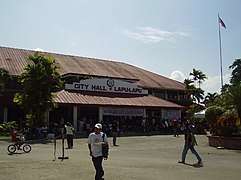 City Hall
 Poblacion (Opon)
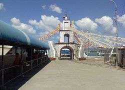 Muelle Osmeña
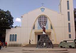 Virgen de la Regla Church
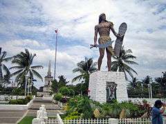 Magellan and Lapu-Lapu shrines
See also
- List of renamed cities and municipalities in the Philippines
Notes
- Part of the Poblacion barangay is still called Opon.
References
- "Province: Cebu". PSGC Interactive. Quezon City, Philippines: Philippine Statistics Authority. Retrieved November 12, 2016.
- Census of Population (2015). "Region VII (Central Visayas)". Total Population by Province, City, Municipality and Barangay. PSA. Retrieved June 20, 2016.
- Inso, Futch Anthony (June 28, 2019). "Lapu-Lapu Mayor Chan's non-Oponganon choices for dep't heads slammed". Cebu Daily News. Philippine Daily Inquirer. Archived from the original on June 29, 2019. Retrieved April 26, 2020.
- "PSA releases the 2015 Municipal and City Level Poverty Estimates". Quezon City, Philippines. Retrieved October 12, 2019.
- Republic Act No. 3134, June 17, 1961, "An Act Creating the City Of Lapu-Lapu" elibrary.judiciary.gov.ph
- About Lapu Lapu City
- Census of Population and Housing (2010). "Region VII (Central Visayas)". Total Population by Province, City, Municipality and Barangay. NSO. Retrieved June 29, 2016.
- "Lapu-Lapu: Average Temperatures and Rainfall". Meteoblue. Retrieved May 10, 2020.
- Censuses of Population (1903–2007). "Region VII (Central Visayas)". Table 1. Population Enumerated in Various Censuses by Province/Highly Urbanized City: 1903 to 2007. NSO.
- "Province of Cebu". Municipality Population Data. Local Water Utilities Administration Research Division. Retrieved December 17, 2016.
Sources
- Gonzales, Glenda R. (December 2004). "Metro Cebu: A Metropolitan Area in Need of Coordinative Body" (PDF). Discussion Paper. 2004-49. Retrieved February 16, 2016.|publisher=Philippine Institute for Development Studies (PIDS) / Surian sa mga Pag-aaral Pangkaunlaran ng Pilipinas|ref=harv}}
External links
| Wikimedia Commons has media related to Lapu-Lapu (Philippines). |
| Wikivoyage has a travel guide for Lapu–Lapu. |
Places adjacent to Lapu-Lapu, Philippines | ||||||||||
|---|---|---|---|---|---|---|---|---|---|---|
| ||||||||||