Prosperidad
Prosperidad, officially the Municipality of Prosperidad (Cebuano: Lungsod sa Prosperidad; Tagalog: Bayan ng Prosperidad), is a 1st class municipality and capital of the province of Agusan del Sur, Philippines. According to the 2015 census, it has a population of 82,631 people.[4]
Prosperidad | |
|---|---|
| Municipality of Prosperidad | |
 Municipal Hall | |
 Seal | |
 Map of Agusan del Sur with Prosperidad highlighted | |
OpenStreetMap 
| |
.svg.png) Prosperidad Location within the Philippines | |
| Coordinates: 8°37′N 125°55′E | |
| Country | |
| Region | Caraga (Region XIII) |
| Province | Agusan del Sur |
| District | 1st District |
| Founded | January 1, 1970 |
| Barangays | 32 (see Barangays) |
| Government | |
| • Type | Sangguniang Bayan |
| • Mayor | Frederick Mark P. Mellana |
| • Vice Mayor | Jesusimo L. Ronquillo |
| • Congressman | Alfelito M. Bascug |
| • Electorate | 47,650 voters (2019) |
| Area | |
| • Total | 505.15 km2 (195.04 sq mi) |
| Elevation | 42.9 m (140.7 ft) |
| Population (2015 census)[4] | |
| • Total | 82,631 |
| • Density | 160/km2 (420/sq mi) |
| • Households | 18,290 |
| Economy | |
| • Income class | 1st municipal income class |
| • Poverty incidence | 40.26% (2015)[5] |
| • Revenue (₱) | 224,696,449.45 (2016) |
| Time zone | UTC+8 (PST) |
| ZIP code | 8500 |
| PSGC | |
| IDD : area code | +63 (0)85 |
| Climate type | tropical rainforest climate |
| Native languages | Agusan language Butuanon Cebuano Higaonon Tagalog |
| Website | www |
Prosperidad was created on June 18, 1960 through Republic Act No. 2650.[6]
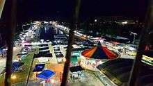
Prosperidad is the venue of the Naliyagan Festival, an annual event celebrated by the entire province of Agusan del Sur. It also hosts its own festival called the Angot Festival celebrated every 28 September in honor of St. Michael the Archangel.
History and etymology
Prior to the Spanish Colonial Period, a Manobo settlement thrived at the junction of the Sianib and Gibong River. This settlement was known to the natives as Culilay.
During the Spanish Colonial Period, the missionaries discovered the settlement and soon began the Christianization of the Manobos. The natives were given Christian names and the settlement was renamed from Culilay to San Juan.
.jpg)
At the start of the American Period, San Juan was again renamed Las Navas but the name was short-lived as the place underwent another change in name – from Las Navas to Prosperidad derived from the word Prospero or "progressive" as the place experienced growth and prosperity during the time of American Governor Zapanta.
Geography

According to the Philippine Statistics Authority, the municipality has a land area of 505.15 square kilometres (195.04 sq mi) [2] constituting 5.06% of the 9,989.52-square-kilometre (3,856.98 sq mi) total area of Agusan del Sur.
Climate
| Climate data for Prosperidad, Agusan del Sur | |||||||||||||
|---|---|---|---|---|---|---|---|---|---|---|---|---|---|
| Month | Jan | Feb | Mar | Apr | May | Jun | Jul | Aug | Sep | Oct | Nov | Dec | Year |
| Average high °C (°F) | 27 (81) |
27 (81) |
28 (82) |
29 (84) |
29 (84) |
29 (84) |
29 (84) |
30 (86) |
30 (86) |
29 (84) |
28 (82) |
28 (82) |
29 (83) |
| Average low °C (°F) | 22 (72) |
22 (72) |
22 (72) |
23 (73) |
23 (73) |
23 (73) |
23 (73) |
23 (73) |
23 (73) |
23 (73) |
23 (73) |
23 (73) |
23 (73) |
| Average precipitation mm (inches) | 152 (6.0) |
116 (4.6) |
90 (3.5) |
68 (2.7) |
88 (3.5) |
96 (3.8) |
78 (3.1) |
73 (2.9) |
70 (2.8) |
96 (3.8) |
125 (4.9) |
132 (5.2) |
1,184 (46.8) |
| Average rainy days | 20.8 | 17.7 | 18.5 | 17.2 | 20.8 | 22.5 | 22.5 | 22.7 | 22.0 | 23.7 | 22.5 | 19.9 | 250.8 |
| Source: Meteoblue [7] | |||||||||||||
Barangays
Prosperidad is politically subdivided into 32 barangays.[8]
| PSGC | Barangay | Population | ±% p.a. | |||
|---|---|---|---|---|---|---|
| 2015[4] | 2010[9] | |||||
| 160306001 | Aurora | 3.9% | 3,251 | 2,999 | 1.55% | |
| 160306002 | Awa | 2.3% | 1,888 | 1,802 | 0.89% | |
| 160306003 | Azpetia | 2.2% | 1,850 | 1,708 | 1.53% | |
| 160306006 | La Caridad | 2.1% | 1,769 | 1,591 | 2.04% | |
| 160306033 | La Perian | 1.0% | 835 | 762 | 1.76% | |
| 160306034 | La Purisima | 2.8% | 2,276 | 2,224 | 0.44% | |
| 160306007 | La Suerte | 2.1% | 1,772 | 1,490 | 3.36% | |
| 160306008 | La Union | 2.2% | 1,853 | 1,509 | 3.99% | |
| 160306009 | Las Navas | 2.2% | 1,785 | 1,535 | 2.91% | |
| 160306010 | Libertad | 1.2% | 985 | 816 | 3.65% | |
| 160306011 | Los Arcos | 3.2% | 2,606 | 2,324 | 2.20% | |
| 160306012 | Lucena | 4.2% | 3,511 | 3,400 | 0.61% | |
| 160306013 | Mabuhay | 2.4% | 2,013 | 1,938 | 0.73% | |
| 160306014 | Magsaysay | 2.8% | 2,339 | 1,944 | 3.58% | |
| 160306015 | Mapaga | 1.9% | 1,558 | 1,394 | 2.14% | |
| 160306017 | Napo | 1.2% | 953 | 984 | −0.61% | |
| 160306016 | New Maug | 1.8% | 1,480 | 1,460 | 0.26% | |
| 160306018 | Patin-ay | 10.3% | 8,505 | 7,562 | 2.26% | |
| 160306004 | Poblacion (Bahbah) | 15.4% | 12,731 | 12,180 | 0.85% | |
| 160306020 | Salimbogaon | 1.0% | 790 | 790 | 0.00% | |
| 160306021 | Salvacion | 3.2% | 2,659 | 2,315 | 2.67% | |
| 160306022 | San Joaquin | 2.1% | 1,720 | 1,484 | 2.85% | |
| 160306023 | San Jose | 3.1% | 2,579 | 2,436 | 1.09% | |
| 160306024 | San Lorenzo | 1.6% | 1,310 | 1,483 | −2.33% | |
| 160306025 | San Martin | 2.9% | 2,379 | 1,929 | 4.07% | |
| 160306026 | San Pedro | 1.0% | 851 | 1,395 | −8.98% | |
| 160306027 | San Rafael | 2.4% | 1,973 | 1,918 | 0.54% | |
| 160306035 | San Roque | 1.3% | 1,093 | 719 | 8.30% | |
| 160306029 | San Salvador | 1.9% | 1,567 | 1,522 | 0.56% | |
| 160306030 | San Vicente | 4.5% | 3,728 | 3,444 | 1.52% | |
| 160306031 | Santa Irene | 7.4% | 6,148 | 5,899 | 0.79% | |
| 160306032 | Santa Maria | 2.3% | 1,874 | 1,672 | 2.20% | |
| Total | 82,631 | 76,628 | 1.45% | |||
Demographics
| Population census of Prosperidad | ||||||||||||||||||||||||||||||||||||||||||||||
|---|---|---|---|---|---|---|---|---|---|---|---|---|---|---|---|---|---|---|---|---|---|---|---|---|---|---|---|---|---|---|---|---|---|---|---|---|---|---|---|---|---|---|---|---|---|---|
|
| |||||||||||||||||||||||||||||||||||||||||||||
| Source: Philippine Statistics Authority[4][9][10][11] | ||||||||||||||||||||||||||||||||||||||||||||||
In the 2015 census, Prosperidad had a population of 82,631.[4] The population density was 160 inhabitants per square kilometre (410/sq mi).
Education
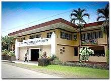
A satellite campus of the Philippine Normal University is located in Poblacion (popularly known as Bahbah) which was established in 1968.
References
- "Municipality". Quezon City, Philippines: Department of the Interior and Local Government. Retrieved 31 May 2013.
- "Province: Agusan del Sur". PSGC Interactive. Quezon City, Philippines: Philippine Statistics Authority. Retrieved 12 November 2016.
- "Prosperidad, Agusan del Sur Profile". PhilAtlas.com. Retrieved 15 June 2020.
- Census of Population (2015). "Caraga". Total Population by Province, City, Municipality and Barangay. PSA. Retrieved 20 June 2016.
- "PSA releases the 2015 Municipal and City Level Poverty Estimates". Quezon City, Philippines. Retrieved 12 October 2019.
- "Republic Act No. 2650; An Act Creating the Municipality of Prosperidad in the Province of Agusan". The Corpus Juris. 18 June 1960. Archived from the original on 18 October 2016. Retrieved 18 October 2016.
- "Prosperidad: Average Temperatures and Rainfall". Meteoblue. Retrieved 29 April 2020.
- "Municipal: Prosperidad". PSGC Interactive. Quezon City, Philippines: Philippine Statistics Authority. Retrieved 8 January 2016.
- Census of Population and Housing (2010). "Caraga". Total Population by Province, City, Municipality and Barangay. NSO. Retrieved 29 June 2016.
- Censuses of Population (1903–2007). "Caraga". Table 1. Population Enumerated in Various Censuses by Province/Highly Urbanized City: 1903 to 2007. NSO.
- "Province of Agusan del Sur". Municipality Population Data. Local Water Utilities Administration Research Division. Retrieved 17 December 2016.
External links
![]()
Places adjacent to Prosperidad | ||||||||||
|---|---|---|---|---|---|---|---|---|---|---|
| ||||||||||
Prosperidad (capital) | |
| Component city | |
| Municipalities | |
| Regional Center | 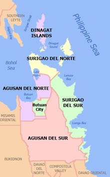 | |
|---|---|---|
| Provinces | ||
| Highly Urbanized City | ||
| Component Cities | ||
| Provincial Capitals |
| |
| Municipalities |
| |
Mindanao, Republic of the Philippines | ||