Batac
Batac (Ilocano: Siudad ti Batac), officially the City of Batac, is a component city in the province of Ilocos Norte, Philippines. According to the 2015 census, it has a population of 55,201 people.[3]
Batac | |
|---|---|
| City of Batac | |
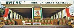 Batac Government Building South Wing | |
 Seal | |
 Map of Ilocos Norte with Batac highlighted | |
OpenStreetMap 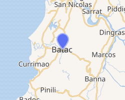
| |
.svg.png) Batac Location within the Philippines | |
| Coordinates: 18°03′19″N 120°33′54″E | |
| Country | |
| Region | Ilocos Region (Region I) |
| Province | Ilocos Norte |
| District | 2nd District |
| Founded | 1577 |
| Cityhood | June 23, 2007 |
| Barangays | 43 (see Barangays) |
| Government | |
| • Type | Sangguniang Panlungsod |
| • Mayor | Albert D. Chua |
| • Vice Mayor | Windell D. Chua |
| • Congressman | Eugenio Angelo M. Barba |
| • Electorate | 37,694 voters (2019) |
| Area | |
| • Total | 161.06 km2 (62.19 sq mi) |
| Elevation | 27.0 m (88.6 ft) |
| Population (2015 census)[3] | |
| • Total | 55,201 |
| • Density | 340/km2 (890/sq mi) |
| • Households | 12,348 |
| Economy | |
| • Income class | 5th city income class |
| • Poverty incidence | 7.75% (2015)[4] |
| • Revenue (₱) | 578,725,718.13 (2016) |
| Time zone | UTC+8 (PST) |
| ZIP code | 2906 |
| PSGC | |
| IDD : area code | +63 (0)77 |
| Climate type | tropical monsoon climate |
| Native languages | Ilocano Tagalog |
| Website | batac |
Etymology
The word Batac translates as "pull" in the Ilocano language. More loosely, it refers to "the people's pulling their efforts together."
Batac has an interesting colloquial origin of its name. According to a legend, set in pre-settlement Batac, a man fell into a deep hole while he was digging for the root crop "camangeg". He struggled to get out but could not despite his best efforts. He cried for help but nobody was around. He waited for hours and had given up hope of being saved. Two men from the neighboring town of Paoay happened to pass by. They heard the man shouting and traced it to where he was trapped. Upon seeing him, they heard the man said "Batakennak! Batakennak!" The two men did not understand until the man explained that he was saying, "Pull me up! Pull me up!" They did just that. When the two men reached their hometown, they told their story to their friends. Since then, the town has been called "Batac," which is derived from the word "batakennak."
History
Batac was founded by the Augustinians in 1587 under the patronage of the Immaculate Conception. It is the second oldest town established by the Augustinians in the province of Ilocos Norte. Hence, in 1987, Batac reached its 4th centennial.
Batac was officially organized into a ministry on January 5, 1586. The first priest assigned to cathecize the natives of tile community was Esteban Marin, an Augustinian who probably arrived in Batac in 1585. Paoay and Dinglas (Dingras) were then the visitas of Batac.
Folk history states that there were two villages in Batac during the early part of tile foundation of the town, one was an Itneg community which occupied sitio Nangalisan and a Christian community occupying San José.
The first site of tile poblacion was in San José, which is now called Barangay Palpalicong. It is said that the ethnic minority groups of Bangui and Nueva Era are the pre-Spanish descendants of early inhabitants of Batac.
The Augustinians considered the people of Batac more civilized than tile other tribes, because they were better than the other "Indios" in personal cleanliness.
Cityhood
Republic Act 9407, the law that converted the Municipality of Batac into a component city in the Province of Ilocos Norte, to be known as Batac City, was overwhelmingly ratified by the people in a plebiscite conducted on June 23, 2007.
Geography
Batac is located in the northwest of Luzon island, about 11 kilometres (6.8 mi) from the eastern shores of the South China Sea, and 470 kilometres (290 mi) from Metro Manila and 17 kilometres (11 mi) from Laoag, the provincial capital. The municipalities of Banna, Currimao, Paoay, Pinili, Sarrat, Marcos and San Nicolas form its boundaries.
Barangays
Batac is politically subdivided into 43 barangays, 14 of which constitute the poblacion. [2]
- Barangay1-S Valdez (Caoayan) (Poblacion)
- Barangay1-N Ricarte (Nalasin) (Poblacion)
- Barangay2 Ablan (Labucao) (Poblacion)
- Barangay3, Cangrunaan (Poblacion)
- Barangay4, Nalupta (Suabit) (Poblacion)
- Barangay5, Callaguip (Poblacion)
- Barangay6, San Julian (Poblacion)
- Barangay7, Caunayan (Poblacion)
- Barangay8, Acosta (Iloilo) (Poblacion)
- Barangay9, Aglipay (Poblacion)
- Barangay10-S, Barani (Poblacion)
- Barangay10-N, Lacub (Poblacion)
- Barangay11 Ben-Agan (Poblacion)
- Barangay12, Palpalicong (Poblacion)
- Barangay13, Baay
- Barangay14, Bungon
- Barangay15, Baligat
- Barangay16-S, Quiling Sur
- Barangay16-N, Quiling Norte
- Barangay17, Tabug
- Barangay18, Magnuang
- Barangay19, Pimentel (Cubol)
- Barangay20-S, Mabaleng
- Barangay20-N, Colo
- Barangay21, Quiom
- Barangay22, Maipalig
- Barangay23, Bininggan
- Barangay24, Sumader
- Barangay25-N, Camguidan
- Barangay25-S, Payao
- Barangay26, Parangopong
- Barangay27-E, Capacuan
- Barangay27-W, Naguirangan
- Barangay28, San Mateo
- Barangay29, San Pedro
- Barangay30-E, Baoa East
- Barangay30-W, Baoa West
- Barangay31, Camandingan
- Barangay32, Palongpong
- Barangay33-S, Rayuray
- Barangay33-N, Nagbacalan
- Barangay34, Dariwdiw
- Barangay35, Bil-loca
Climate
| Climate data for Batac City | |||||||||||||
|---|---|---|---|---|---|---|---|---|---|---|---|---|---|
| Month | Jan | Feb | Mar | Apr | May | Jun | Jul | Aug | Sep | Oct | Nov | Dec | Year |
| Average high °C (°F) | 27 (81) |
28 (82) |
30 (86) |
32 (90) |
31 (88) |
31 (88) |
30 (86) |
30 (86) |
30 (86) |
29 (84) |
28 (82) |
27 (81) |
29 (85) |
| Average low °C (°F) | 20 (68) |
20 (68) |
21 (70) |
23 (73) |
25 (77) |
25 (77) |
25 (77) |
25 (77) |
24 (75) |
23 (73) |
22 (72) |
21 (70) |
23 (73) |
| Average precipitation mm (inches) | 38 (1.5) |
37 (1.5) |
37 (1.5) |
49 (1.9) |
181 (7.1) |
214 (8.4) |
264 (10.4) |
251 (9.9) |
243 (9.6) |
229 (9.0) |
129 (5.1) |
96 (3.8) |
1,768 (69.7) |
| Average rainy days | 11.6 | 10.7 | 12.4 | 15.2 | 22.6 | 25.0 | 26.1 | 24.9 | 24.3 | 19.2 | 16.4 | 15.4 | 223.8 |
| Source: Meteoblue [5] | |||||||||||||
Demographics
| Population census of Batac | |||||||||||||||||||||||||||||||||||||||||||||||||
|---|---|---|---|---|---|---|---|---|---|---|---|---|---|---|---|---|---|---|---|---|---|---|---|---|---|---|---|---|---|---|---|---|---|---|---|---|---|---|---|---|---|---|---|---|---|---|---|---|---|
|
| ||||||||||||||||||||||||||||||||||||||||||||||||
| Source: Philippine Statistics Authority[3][6][7][8] | |||||||||||||||||||||||||||||||||||||||||||||||||
In the 2015 census, the population of Batac was 55,201 people,[3] with a density of 340 inhabitants per square kilometre or 880 inhabitants per square mile.
Economy
The Batac City Public Market touted as one of the biggest in the region offers a wide array of goods – freshly picked local vegetables and fruits, handicrafts, tincrafts, pottery, native delicacies, chicharon, longganisa, wet market treats and many others. The Delicia Center, located adjacent to the City Public Market, contains RTW shops, banks, appliance stores, farm supplies, pharmacies, groceries, a lottery outlet and many more. The Delicia Center and the City Public Market form part of the commercial district of Batac City.
With the presence of the Central Bank of the Philippines Cash Unit in the Batac City Government Center, financial institutions continue to spawn – Philippine National Bank, RCBC, Metrobank, Land Bank, BPI, Bank of Commerce, BDO and other local banks. Proof that Batac is offering a good business climate to investors.
The Plaza Maestro Complex, one of the most modern shopping centers in the province caters to the needs of the new generation, offering two of the country's top fast food chains (Jollibee and Chowking), several boutique shops, a drugstore and a photo shop, among others. A stone's throw away from the commercial complex are bakeshops and a local pizza house.
Tourism

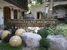
The Marcos Museum and Mausoleum is situated in the city center. The Mausoleum is where the glass-entombed, preserved corpse of Former President Ferdinand E. Marcos is found. The Museum holds the memorabilia of then President, from his stint in the Armed Forces down to his presidency. Other notable figures who hails from Batac include Gen. Artemio Ricarte, the Father of the Philippine Army and Msgr. Gregorio Aglipay, the founder of the Philippine Independent Church. Monuments and shrines of these personalities had been erected and named after them.
The Batac Riverside Empanadaan is a retail and dining center catering to tourist selling food products including the city's primary commodity of Batac, the empanada, and other souvenirs and products.
The city has two festivals, The Farmers Festival and The Empanada Festival. The Farmers' Festival, conducted in the first week of May each year is a celebration of bountiful harvest and a tribute to the farmers of the city. It is participated by the rural barangays of the city. The Empanada Festival is a festivity held on the 23rd of June in celebration of the City's Charter Day. The main feature of the festival is the street dancing which chronicles the process of preparing the empanada.
The Batac City Fiesta, a month-long festivity commencing on the 8th of December, is the longest fiesta in the Province of Ilocos Norte. The fiesta is celebrated in honor of the city's patroness, Our Lady of the Immaculate Conception. The Electric and Lights Parade marks the beginning of the City Fiesta every December 8.
Local government
Term of Office: June 30, 2019 – June 30, 2022
| City Mayor | Engr. Albert D. Chua |
|---|---|
| City Vice Mayor | Atty. Windell D. Chua |
| City Councilors |
|
| ABC President | Joseph P. Ulit |
| SK Federated President | John Gabrielle Dominique M. Daguio |
List of mayors
- 1900: Sereno Franco
- 1904: Claudio Asuncion
- 1906: Sereno Franco
- 1910: Santiago Espiritu
- 1912: Galo Luzod
- 1916: Higidio Layaoen
- 1917: Mauricio Sabas
- 1919: Higidio Layaoen
- 1922: Isidro Morales
- 1925: Eugenio Mendoza
- 1928: Urbano Arcangel
- 1931: Eugenio Mendoza, Sr.
- 1934: Leon Verano
- 1941: Catalino Acosta
- 1942: Sereno Franco (Japanese Occupation)
- 1942: Catalino Acosta (Liberation)
- 1945: Vicente Castro (Military Government)
- 1946-1952: Mariano Nalupta, Sr.
- 1956-1977: Feliciano Q. Asuncion
- 1977-1987: Fe P. Acosta - Aguinaldo
- 1986-1987: Bonifacio G. Agdigos (OIC)
- 1987-1988: Pastor N. Nalupta
- 1988–1998: Jesus R. Nalupta, Sr.
- 1998-2001: Elena M. Nalupta
- 2001-2007: Jesus R. Nalupta, Sr.
- 2007–2016: Jeffrey Jubal C. Nalupta
- 2016–Present: Albert D. Chua
Education
Batac National High School (BNHS) is the most popular high school in the city. It has three campuses: Poblacion, Bungon and Payao.
The Mariano Marcos State University (MMSU) is a comprehensive institution of higher learning in the Ilocos Region. MMSU's root anchored deep, its foundation is strong, and its beginnings all proven historical turning points as far back as the early 1900s.
The city has one Catholic School, The Immaculate Conception Academy. It was named after Immaculate Conception, the patron saint of the city. It is under the Missionary Sisters Servants of the Holy Spirit (SSpS). It was founded in 1963. It is located beside the Immaculate Conception Parish.
Notable people
 Ferdinand Marcos – The 10th President of the Philippines from 1965 to 1986.
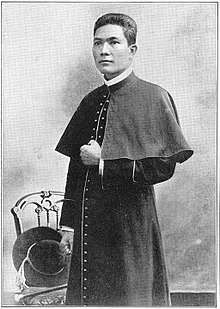 Gregorio Aglipay - Founder and the First Supreme Bishop of the Philippine Independent Church.
 Artemio Ricarte – A Filipino general during the Philippine Revolution and the Philippine–American War. Considered the "Father of the Philippine Army".
 Rodolfo Biazon – Senator of the Philippines from June 30, 1992 up to June 30, 1995, and from June 30, 1998 up to June 30, 2010.
References
- "City". Quezon City, Philippines: Department of the Interior and Local Government. Retrieved 30 May 2013.
- "Province: Ilocos Norte". PSGC Interactive. Quezon City, Philippines: Philippine Statistics Authority. Retrieved 12 November 2016.
- Census of Population (2015). "Region I (Ilocos Region)". Total Population by Province, City, Municipality and Barangay. PSA. Retrieved 20 June 2016.
- "PSA releases the 2015 Municipal and City Level Poverty Estimates". Quezon City, Philippines. Retrieved 1 January 2020.
- "Batac: Average Temperatures and Rainfall". Meteoblue. Retrieved 4 March 2020.
- Census of Population and Housing (2010). "Region I (Ilocos Region)". Total Population by Province, City, Municipality and Barangay. NSO. Retrieved 29 June 2016.
- Censuses of Population (1903–2007). "Region I (Ilocos Region)". Table 1. Population Enumerated in Various Censuses by Province/Highly Urbanized City: 1903 to 2007. NSO.
- "Province of Ilocos Norte". Municipality Population Data. Local Water Utilities Administration Research Division. Retrieved 17 December 2016.
External links
| Wikimedia Commons has media related to Batac, Ilocos Norte. |
- Official Website of Batac
- Batac Profile at PhilAtlas.com
- Philippine Standard Geographic Code
- Philippine Census Information
- Local Governance Performance Management System
Places adjacent to Batac | ||||||||||
|---|---|---|---|---|---|---|---|---|---|---|
| ||||||||||
