Mapandan, Pangasinan
Mapandan, officially the Municipality of Mapandan, (Pangasinan: Baley na Mapandan; Ilocano: Ili ti Mapandan; Tagalog: Bayan ng Mapandan), is a 3rd class municipality in the province of Pangasinan, Philippines. According to the 2015 census, it has a population of 37,059 people.[3]
Mapandan | |
|---|---|
| Municipality of Mapandan | |
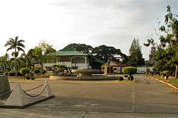 Poblacion and Municipal Hall | |
 Seal | |
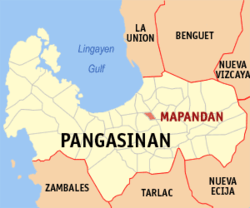 Map of Pangasinan with Mapandan highlighted | |

| |
.svg.png) Mapandan Location within the Philippines | |
| Coordinates: 16°01′00″N 120°27′00″E | |
| Country | |
| Region | Ilocos Region (Region I) |
| Province | Pangasinan |
| District | 3rd district |
| Barangays | 15 (see Barangays) |
| Government | |
| • Type | Sangguniang Bayan |
| • Mayor | Anthony C. Penuliar |
| • Vice Mayor | Asuncion D. Calimlim |
| • Congressman | Rose Marie J. Arenas |
| • Electorate | 24,092 voters (2019) |
| Area | |
| • Total | 30.00 km2 (11.58 sq mi) |
| Elevation | 15.0 m (49.2 ft) |
| Population (2015 census)[3] | |
| • Total | 37,059 |
| • Density | 1,200/km2 (3,200/sq mi) |
| • Households | 7,596 |
| Economy | |
| • Income class | 3rd municipal income class |
| • Poverty incidence | 11.38% (2015)[4] |
| • Revenue (₱) | 86,483,211.72 (2016) |
| Time zone | UTC+8 (PST) |
| ZIP code | 2429 |
| PSGC | |
| IDD : area code | +63 (0)75 |
| Climate type | tropical monsoon climate |
| Native languages | Pangasinan Ilocano Tagalog |

Mapandan is a Hall of Famer for having the Pangasinan's cleanest, safest and greenest municipality (Category B). Mapandan was also awarded the Pangasinan's Healthiest Municipality for having the fewest malnourished children.
Mapandan is known for its yearly Pandan Festival.
Etymology
The municipality was formerly a barrio of Mangaldan. It was conceived into a municipality in 1909. Mapandan (meaning plenty of pandan) got its name from “pandan”, a native palm which grew in abundance in the place at that time. The leaves of the pandan add aroma to the cooked rice if cooked with it. The leaves are also stripped and woven into mats.
Geography
Mapandan is located in Eastern-Central part of Pangasinan. Bordered by Mangaldan to the north, Manaoag to the east, and Santa Barbara to the west and southern part.
Mapandan is landlocked, however, it is not too far from nearby coastal areas of Dagupan City, Binmaley and Mangaldan.
Mapandan is located in central hilly area, having several mountains nearby.
It has a little part of Bued river in northern part and an irrigation project also known as Payas irrigation project, which aims for a standard irrigation for farming areas in the municipality.
History
Mapandan was a former mere Barrio. That was former part of Municipality of Mangaldan.
It is composed of farming areas and cattle ranch farms.
Mapandan is practically rural in terms of its area.
Barangays
Mapandan is politically subdivided into 15 barangays:
- Amanoaoac
- Apaya
- Aserda
- Baloling
- Coral
- Golden
- Jimenez
- Lambayan
- Luyan
- Nilombot
- Pias
- Poblacion
- Primicias
- Santa Maria
- Torres
Demographics
| Population census of Mapandan | ||
|---|---|---|
| Year | Pop. | ±% p.a. |
| 1903 | 4,198 | — |
| 1918 | 6,049 | +2.47% |
| 1939 | 7,286 | +0.89% |
| 1948 | 9,836 | +3.39% |
| 1960 | 13,065 | +2.39% |
| 1970 | 16,653 | +2.45% |
| 1975 | 18,143 | +1.73% |
| 1980 | 20,094 | +2.06% |
| 1990 | 25,622 | +2.46% |
| 1995 | 27,439 | +1.29% |
| 2000 | 30,775 | +2.49% |
| 2007 | 32,905 | +0.93% |
| 2010 | 34,439 | +1.67% |
| 2015 | 37,059 | +1.41% |
| Source: Philippine Statistics Authority[3][5][6][7] | ||
Dialects
Pangasinan and Ilocano are the main dialects in the town, second is the Kapampangan dialect. Filipino-Tagalog based is also spoken in the town.
Religions
Major religions are in the town, with different branches of churches within.
- Seventh-day Adventist Church (Poblacion and Kolos-Pias)
- Iglesia ni Cristo (Nilombot and Luyan)
- The Grand Mosque (Luyan)
- The Church of Jesus Christ of Latter Day Saints (Nilombot)
- Kingdom hall of Jehovas Witnesses (Coral)
- Roman Catholicism (Poblacion and Luyan)
- Good news to the Nations Outreach (Poblacion)
- Born Again Christianity (Poblacion)
Roman Catholicism is the major Religion in Mapandan, annexed by different religions around.
Climate
| Climate data for Mapandan, Pangasinan | |||||||||||||
|---|---|---|---|---|---|---|---|---|---|---|---|---|---|
| Month | Jan | Feb | Mar | Apr | May | Jun | Jul | Aug | Sep | Oct | Nov | Dec | Year |
| Average high °C (°F) | 29 (84) |
29 (84) |
30 (86) |
32 (90) |
33 (91) |
33 (91) |
33 (91) |
33 (91) |
33 (91) |
32 (90) |
31 (88) |
29 (84) |
31 (88) |
| Average low °C (°F) | 21 (70) |
21 (70) |
22 (72) |
23 (73) |
24 (75) |
24 (75) |
23 (73) |
24 (75) |
23 (73) |
23 (73) |
22 (72) |
21 (70) |
23 (73) |
| Average precipitation mm (inches) | 127.5 (5.02) |
115.8 (4.56) |
129.7 (5.11) |
141.1 (5.56) |
248.2 (9.77) |
165 (6.5) |
185.3 (7.30) |
161.9 (6.37) |
221.4 (8.72) |
299.5 (11.79) |
199 (7.8) |
188.7 (7.43) |
2,183.1 (85.93) |
| Average rainy days | 17 | 17 | 17 | 15 | 20 | 19 | 19 | 20 | 21 | 20 | 17 | 19 | 221 |
| Source: World Weather Online[8] | |||||||||||||
References
- "Municipality". Quezon City, Philippines: Department of the Interior and Local Government. Retrieved 31 May 2013.
- "Province: Pangasinan". PSGC Interactive. Quezon City, Philippines: Philippine Statistics Authority. Retrieved 12 November 2016.
- Census of Population (2015). "Region I (Ilocos Region)". Total Population by Province, City, Municipality and Barangay. PSA. Retrieved 20 June 2016.
- "PSA releases the 2015 Municipal and City Level Poverty Estimates". Quezon City, Philippines. Retrieved 1 January 2020.
- Census of Population and Housing (2010). "Region I (Ilocos Region)". Total Population by Province, City, Municipality and Barangay. NSO. Retrieved 29 June 2016.
- Censuses of Population (1903–2007). "Region I (Ilocos Region)". Table 1. Population Enumerated in Various Censuses by Province/Highly Urbanized City: 1903 to 2007. NSO.
- "Province of Pangasinan". Municipality Population Data. Local Water Utilities Administration Research Division. Retrieved 17 December 2016.
- "Mapandan, Pangasinan: Average Temperatures and Rainfall". World Weather Online. Retrieved 12 October 2015.
External links
| Wikimedia Commons has media related to Mapandan, Pangasinan. |
- Mapandan Profile at PhilAtlas.com
- Municipal Profile at the National Competitiveness Council of the Philippines
- Mapandan at the Pangasinan Government Website
- Local Governance Performance Management System
- Philippine Standard Geographic Code
- Philippine Census Information
- Pangasinan.org : Mapandan Family and School Reunion Archives
Places adjacent to Mapandan, Pangasinan | ||||||||||
|---|---|---|---|---|---|---|---|---|---|---|
| ||||||||||
Lingayen (capital) | |
| Municipalities |
|
| Component cities | |
| Independent component city |
|
| Barangays | |