Mangaldan, Pangasinan
Mangaldan, officially the Municipality of Mangaldan, (Pangasinan: Baley na Mangaldan; Ilocano: Ili ti Mangaldan; Tagalog: Bayan ng Mangaldan), is a 1st class municipality in the province of Pangasinan, Philippines. According to the 2015 census, it has a population of 106,331 people.[3]
Mangaldan | |
|---|---|
| Municipality of Mangaldan | |
 | |
 Seal | |
| Anthem: Abante Mangaldan | |
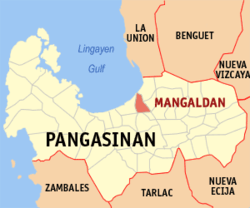 Map of Pangasinan with Mangaldan highlighted | |

| |
.svg.png) Mangaldan Location within the Philippines | |
| Coordinates: 16°04′12″N 120°24′09″E | |
| Country | |
| Region | Ilocos Region (Region I) |
| Province | Pangasinan |
| District | 4th district |
| Founded | June 2, 1600 |
| Barangays | 30 (see Barangays) |
| Government | |
| • Type | Sangguniang Bayan |
| • Mayor | Mary Marilyn D. Lambino |
| • Vice Mayor | Pedro A. Surdilla, Jr. |
| • Congressman | Christopher George Martin P. De Venecia |
| • Electorate | 65,115 voters (2019) |
| Area | |
| • Total | 48.47 km2 (18.71 sq mi) |
| Elevation | 7.7 m (25.3 ft) |
| Population (2015 census)[3] | |
| • Total | 106,331 |
| • Density | 2,200/km2 (5,700/sq mi) |
| • Households | 22,611 |
| Economy | |
| • Income class | 1st municipal income class |
| • Poverty incidence | 11.48% (2015)[4] |
| • Revenue (₱) | 220,495,451.74 (2016) |
| Time zone | UTC+8 (PST) |
| ZIP code | 2432 |
| PSGC | |
| IDD : area code | 2432 |
| Climate type | tropical monsoon climate |
| Native languages | Pangasinan Ilocano Tagalog |
| Website | www |
Background
Mangaldan was founded by Dominican order missionaries from Spain (the third such city in Pangasinan). It is known to have already been a Spanish encomienda by 1591. During World War II, Mangaldan had an airstrip that was used by the American military.
Mangaldan celebrates its annual Pindang Festival along with its town fiesta during first week of March. The popular carabeef tapa (Filipino-style dried meat), locally known as pindang is the One Town One Product (OTOP) of this municipality.[5] It is also home of the original makers of the famous delicacy – the Romana Peanut Brittle. The town bagged the grand slam award when its inland body of water, the Angalacan River, was adjudged as the cleanest river in the entire province for the third time which was awarded in 2012.[6]
One of the major sources of revenues here are the thriving market place and the laboratories of renowned pharmaceutical companies that buttressed the coffer of this town.[7]The municipal government operates its slaughterhouse with a rated "double A" by the National Meat Inspection Service (NMIS) that guarantees the butchered meat as safe and clean.
In 2015, the annual budget of Mangaldan involving a total appropriation of Php 208, 527, 497.39 which would be the biggest for a first class town in Pangasinan.[8]
Municipal Councilors
- Councilor Atty. Joseph Emmanuel Cera
- Councilor Ma. Teresa "Baby" Abalos, Pro Tempore
- Councilor Dr. Joselito "Jojo" Quinto
- Councilor Aldrin Soriano
- Councilor Christopher Romero
- Councilor Joel Meneses
- Councilor Atty. Fernando Juan "Johnny" Cabrera
- Councilor Juvy Frialde
Barangays
Mangaldan is politically subdivided into 30 barangays.
- Alitaya
- Amansabina
- Anolid
- Banaoang
- Bantayan
- Bari
- Bateng
- Buenlag
- David
- Embarcadero
- Gueguesangen
- Guesang
- Guiguilonen
- Guilig
- Inlambo
- Lanas
- Landas
- Maasin
- Macayug
- Malabago
- Navaluan
- Nibaliw
- Osiem
- Palua
- Poblacion
- Pogo
- Salaan
- Salay
- Talogtog
- Tebag
History
Mangaldan owns the distinction as the third town in Pangasinan to be founded by the Dominican missionaries. As early as 1591, Mangaldan already existed as a Spanish encomienda. Its foundation as a town is attributed to Blessed Juan Martinez de Santo Domingo, a former missionary of Pangasinan who died a martyr's death in Japan on 19 March 1618.
Mangaldan started as a "visita" of Calasiao and it remained as such until the Dominicans created it as an independent vicariate under the patronage of St. Thomas Aquinas on 2 June 1600.
It is said that of all the people of Pangasinan, the Mangaldanian were the most difficult to convert. The greatest enemy of the missionaries in the town was a certain man named Casipit who tried to force them out of the town and even attempted to kill some of them. Yet, when he was converted by the first apostle, Fr. Pedro Soto, he became the principal propagator of the Faith. He contributed a great sum of money for the construction of the first church.
In the second half of the 19th century, Mangaldan was the richest town in the province. This was due to the famous irrigation system which the missionaries built within the confines of the town[10] causing its fertile fields to yield bountiful harvest of palay. Most outstanding in this gigantic task was Fr. Jose Torres who gave his life to bring it to completion in 1892.
The third church to be built in Mangaldan was completed in 1812 by Fr. Lorenzo Martin. It collapsed during the great earthquake of 16 March 1892, together with the big chapel in the cemetery. The construction of the convent dates back in 1747. The construction of the sixth and present church of Mangaldan was begun in 1942 by Fr. Juan Sison, and was completed 20 years later by Fr. Leon Bitanga.
Geography
Mangaldan is located in the central part of Pangasinan. The municipality is bordered by San Fabian on the north, Dagupan on the west, San Jacinto on the east and on the south, the municipalities of Mapandan and Santa Barbara.
It is 210 km away from the country's Capital, Manila, 68 km away from the country's Summer Capital Baguio and 24.1 km away from the province's Capital, Lingayen.
Rivers
There are four rivers in Mangaldan: the Old Mangaldan River, the Manguiragday River, the Angalacan River and the Paldakit River.
Demographics
| Population census of Mangaldan | ||
|---|---|---|
| Year | Pop. | ±% p.a. |
| 1903 | 15,841 | — |
| 1918 | 16,761 | +0.38% |
| 1939 | 18,997 | +0.60% |
| 1948 | 26,102 | +3.59% |
| 1960 | 33,422 | +2.08% |
| 1970 | 41,867 | +2.28% |
| 1975 | 46,230 | +2.01% |
| 1980 | 50,434 | +1.76% |
| 1990 | 65,947 | +2.72% |
| 1995 | 73,351 | +2.01% |
| 2000 | 82,142 | +2.46% |
| 2007 | 90,391 | +1.33% |
| 2010 | 98,905 | +3.33% |
| 2015 | 106,331 | +1.39% |
| Source: Philippine Statistics Authority[3][11][12][13] | ||
Climate
| Climate data for Mangaldan, Pangasinan | |||||||||||||
|---|---|---|---|---|---|---|---|---|---|---|---|---|---|
| Month | Jan | Feb | Mar | Apr | May | Jun | Jul | Aug | Sep | Oct | Nov | Dec | Year |
| Average high °C (°F) | 31 (88) |
31 (88) |
33 (91) |
34 (93) |
34 (93) |
33 (91) |
32 (90) |
31 (88) |
31 (88) |
32 (90) |
31 (88) |
31 (88) |
32 (90) |
| Average low °C (°F) | 21 (70) |
21 (70) |
23 (73) |
25 (77) |
25 (77) |
25 (77) |
25 (77) |
24 (75) |
24 (75) |
24 (75) |
23 (73) |
22 (72) |
24 (74) |
| Average precipitation mm (inches) | 4.3 (0.17) |
19.1 (0.75) |
27.3 (1.07) |
45.2 (1.78) |
153.3 (6.04) |
271.3 (10.68) |
411.1 (16.19) |
532 (20.9) |
364.4 (14.35) |
182.5 (7.19) |
56.3 (2.22) |
24.4 (0.96) |
2,091.2 (82.3) |
| Average rainy days | 3 | 2 | 3 | 5 | 14 | 17 | 22 | 23 | 21 | 13 | 7 | 4 | 134 |
| Source: World Weather Online[14] | |||||||||||||
Schools & Institutions
Private Schools
- Cherished Moments School
- Santo Tomas Catholic School
- Aura Vista Montessori and High School
- Clarice Angels School
- Golden Angels Educational Institute
- The Right Formation School
- Mangaldan Achievers Academy
- Metro-Dagupan Colleges
- United Methodist Church Cinderella School
Public Schools
- Mangaldan Central School
- Bantayan Integrated School
- David National High School
- Mangaldan National High School
- Gueguesangen Integrated School
- Embarcadero Mangaldan School
Images
 Welcome sign
 Centro and the Municipal Building
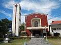 Vicariate of Santo Tomas de Aquino, Parish of St. Thomas Aquinas
 Police Station
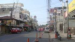
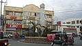 Junction, crossing

References
- "Municipality". Quezon City, Philippines: Department of the Interior and Local Government. Retrieved 31 May 2013.
- "Province: Pangasinan". PSGC Interactive. Quezon City, Philippines: Philippine Statistics Authority. Retrieved 12 November 2016.
- Census of Population (2015). "Region I (Ilocos Region)". Total Population by Province, City, Municipality and Barangay. PSA. Retrieved 20 June 2016.
- "PSA releases the 2015 Municipal and City Level Poverty Estimates". Quezon City, Philippines. Retrieved 1 January 2020.
- Viray, Marla (27 June 2011). "Family stamps own brand on 'tapa'". newsinfo.inquirer.net. Retrieved 1 June 2017.
- http://www.ptvnews.ph/bottom-news-life2/16-16-environment/274-mangaldan-river-adjudged-pangasinans-cleanest
- http://wwwmortzcortigoza.blogspot.com/2011/12/mangaldan-is-richer-than-other-major.html
- "DECLARING THE ANNUAL BUDGET FOR CALENDAR YEAR 2014 OF MANGALDAN, PANGASINAN INVOLVING A TOTAL APPROPRIATION OF P178,658,338.35 OPERATIVE IN ITS ENTIRETY | The Official Website of the Province of Pangasinan and its People". pangasinan.gov.ph. Retrieved 1 June 2017.
- "Halalan 2019 Results". ABS-CBN News. Retrieved 8 August 2019.
- http://capitalpangasinan.blogspot.com/2008/02/mangaldan-church.html
- Census of Population and Housing (2010). "Region I (Ilocos Region)". Total Population by Province, City, Municipality and Barangay. NSO. Retrieved 29 June 2016.
- Censuses of Population (1903–2007). "Region I (Ilocos Region)". Table 1. Population Enumerated in Various Censuses by Province/Highly Urbanized City: 1903 to 2007. NSO.
- "Province of Pangasinan". Municipality Population Data. Local Water Utilities Administration Research Division. Retrieved 17 December 2016.
- "Mangaldan, Pangasinan: Average Temperatures and Rainfall". World Weather Online. Retrieved 12 October 2015.
External links
| Wikimedia Commons has media related to Mangaldan. |
- Mangaldan Official Website
- Mangaldan Profile at PhilAtlas.com
- Municipal Profile at the National Competitiveness Council of the Philippines
- Mangaldan at the Pangasinan Government Website
- Local Governance Performance Management System
- Philippine Standard Geographic Code
- Philippine Census Information
- Pangasinan.org : Mangaldan Family and School Reunion Archives
- RESIDENCIA SAN JOSE
- / 2019 Philippine Elections]
Places adjacent to Mangaldan, Pangasinan | ||||||||||
|---|---|---|---|---|---|---|---|---|---|---|
| ||||||||||
Lingayen (capital) | |
| Municipalities |
|
| Component cities | |
| Independent component city |
|
| Barangays | |