Naga, Cebu
Naga, officially the City of Naga (Cebuano: Dakbayan sa Naga; Tagalog: Lungsod ng Naga), is a 5th class city in the province of Cebu, Philippines. According to the 2015 census, it has a population of 115,750 people.[4]
Naga | |
|---|---|
| City of Naga | |
 | |
Seal | |
| Nickname(s): The Industrial Hub of Southern Cebu[1] | |
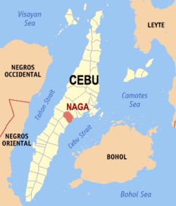 Map of Cebu with Naga highlighted | |
| |
.svg.png) Naga Location within the Philippines | |
| Coordinates: 10°13′N 123°45′E | |
| Country | |
| Region | Central Visayas (Region VII) |
| Province | Cebu |
| District | 1st district of Cebu |
| Founded | 1785 |
| Cityhood | 2007 |
| Barangays | 28 (see Barangays) |
| Government | |
| • Type | Sangguniang Panlungsod |
| • Mayor | Kristine Vanessa T. Chiong |
| • Vice Mayor | Virgilio M. Chiong |
| • Congressman | Eduardo R. Gullas |
| • Electorate | 74,948 voters (2019) |
| Area | |
| • Total | 101.97 km2 (39.37 sq mi) |
| Elevation | 5.2 m (17.1 ft) |
| Population (2015 census)[4] | |
| • Total | 115,750 |
| • Density | 1,100/km2 (2,900/sq mi) |
| • Households | 26,011 |
| Economy | |
| • Income class | 5th city income class |
| • Poverty incidence | 21.12% (2015)[5] |
| • Revenue (₱) | 463,120,652.25 (2016) |
| Time zone | UTC+8 (PST) |
| ZIP code | 6037 |
| PSGC | |
| IDD : area code | +63 (0)32 |
| Climate type | tropical climate |
| Native languages | Cebuano Tagalog |
| Website | www |
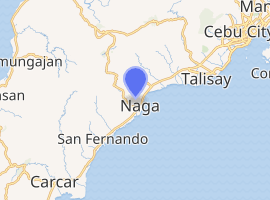
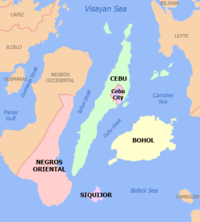
Naga City is bordered to the north by the town of Minglanilla, to the west is the city of Toledo, to the east is the Cebu Strait, and to the south is the town of San Fernando.
It lies within the Cebu metropolitan area.
It is one of the two Philippine cities named Naga, the other being Naga in Camarines Sur. As such, the city is often confused by visitors coming primarily from Luzon and other parts of the country not near to Central Visayas with the city in Camarines Sur.
Barangays
Naga comprises 28 barangays:
| PSGC | Barangay | Population | ±% p.a. | |||
|---|---|---|---|---|---|---|
| 2015[4] | 2010[6] | |||||
| 0772234001 | Alpaco | 3.0% | 3,486 | 2,921 | 3.42% | |
| 0772234002 | Bairan | 1.9% | 2,173 | 1,772 | 3.96% | |
| 0772234003 | Balirong | 4.1% | 4,760 | 3,918 | 3.78% | |
| 0772234004 | Cabungahan | 1.1% | 1,306 | 1,176 | 2.02% | |
| 0772234005 | Cantao‑an | 5.1% | 5,889 | 5,133 | 2.65% | |
| 0772234006 | Central Poblacion | 0.8% | 896 | 933 | −0.77% | |
| 0772234007 | Cogon | 3.7% | 4,267 | 3,583 | 3.38% | |
| 0772234008 | Colon | 3.9% | 4,467 | 4,227 | 1.06% | |
| 0772234009 | East Poblacion | 0.5% | 636 | 544 | 3.02% | |
| 0772234011 | Inayagan | 7.2% | 8,342 | 7,832 | 1.21% | |
| 0772234010 | Inoburan | 5.2% | 6,054 | 5,104 | 3.30% | |
| 0772234012 | Jaguimit | 2.0% | 2,344 | 2,071 | 2.39% | |
| 0772234013 | Lanas | 2.5% | 2,890 | 2,374 | 3.82% | |
| 0772234014 | Langtad | 5.4% | 6,220 | 6,900 | −1.96% | |
| 0772234015 | Lutac | 4.0% | 4,603 | 3,879 | 3.31% | |
| 0772234016 | Mainit | 2.4% | 2,770 | 2,695 | 0.52% | |
| 0772234017 | Mayana | 1.1% | 1,299 | 1,295 | 0.06% | |
| 0772234018 | Naalad | 2.5% | 2,937 | 2,700 | 1.61% | |
| 0772234019 | North Poblacion | 2.6% | 3,019 | 2,866 | 1.00% | |
| 0772234020 | Pangdan | 4.1% | 4,730 | 4,643 | 0.35% | |
| 0772234021 | Patag | 1.2% | 1,419 | 1,167 | 3.79% | |
| 0772234022 | South Poblacion | 4.9% | 5,673 | 4,459 | 4.69% | |
| 0772234023 | Tagjaguimit | 2.0% | 2,317 | 2,302 | 0.12% | |
| 0772234024 | Tangke | 4.5% | 5,263 | 4,652 | 2.38% | |
| 0772234025 | Tinaan | 6.2% | 7,157 | 4,129 | 11.04% | |
| 0772234027 | Tuyan | 9.8% | 11,337 | 10,705 | 1.10% | |
| 0772234028 | Uling | 5.3% | 6,187 | 4,470 | 6.38% | |
| 0772234029 | West Poblacion | 2.9% | 3,309 | 3,121 | 1.12% | |
| Total | 115,750 | 101,571 | 2.52% | |||
Climate
| Climate data for Naga City, Cebu | |||||||||||||
|---|---|---|---|---|---|---|---|---|---|---|---|---|---|
| Month | Jan | Feb | Mar | Apr | May | Jun | Jul | Aug | Sep | Oct | Nov | Dec | Year |
| Average high °C (°F) | 28 (82) |
29 (84) |
30 (86) |
31 (88) |
31 (88) |
30 (86) |
30 (86) |
30 (86) |
30 (86) |
29 (84) |
29 (84) |
28 (82) |
30 (85) |
| Average low °C (°F) | 23 (73) |
23 (73) |
23 (73) |
24 (75) |
25 (77) |
25 (77) |
25 (77) |
25 (77) |
25 (77) |
25 (77) |
24 (75) |
23 (73) |
24 (75) |
| Average precipitation mm (inches) | 70 (2.8) |
49 (1.9) |
62 (2.4) |
78 (3.1) |
138 (5.4) |
201 (7.9) |
192 (7.6) |
185 (7.3) |
192 (7.6) |
205 (8.1) |
156 (6.1) |
111 (4.4) |
1,639 (64.6) |
| Average rainy days | 13.4 | 10.6 | 13.1 | 14.5 | 24.2 | 27.9 | 28.4 | 27.7 | 27.1 | 27.4 | 22.5 | 15.9 | 252.7 |
| Source: Meteoblue [7] | |||||||||||||
Demographics

| Population census of Naga | ||
|---|---|---|
| Year | Pop. | ±% p.a. |
| 1903 | 16,884 | — |
| 1918 | 21,166 | +1.52% |
| 1939 | 25,850 | +0.96% |
| 1948 | 24,911 | −0.41% |
| 1960 | 32,475 | +2.23% |
| 1970 | 35,043 | +0.76% |
| 1975 | 38,242 | +1.77% |
| 1980 | 45,831 | +3.69% |
| 1990 | 60,425 | +2.80% |
| 1995 | 69,010 | +2.52% |
| 2000 | 80,189 | +3.27% |
| 2007 | 95,163 | +2.39% |
| 2010 | 101,571 | +2.40% |
| 2015 | 115,750 | +2.52% |
| Source: Philippine Statistics Authority[4][6][8][9] | ||
Economy
Among the industries in Naga are the Apo Cement Corporation, the largest factory in the country, producing 4,000 metric tons (3,900 long tons) per day; FSP Group; the 290-megawatt KEPCO Philippines Corporation power plant; MRC Allied Industries; Kyocera Kinseki Philippines, Inc.; Pryce Gases, Inc.; Rikio Southeast Asia; and the 147-megawatt coal-fired Salcon Power Corporation plant.[1]
Cityhood
Cityhood was ratified in a plebiscite on 2 September 2007.
Sports venues
In December 2015 Naga City government inaugurated the Teodoro Mendiola Sports Field and Oval, located along North Poblacion. It was ready for the main venue for the 2016 Central Visayas Regional Athletic Association (CVIRAA) games in February. The ₱68 million project comprises a track and field oval, swimming pool (Olympic-sized), and basketball, tennis, and volleyball courts.[10]
2017 the first time a host became back-in-back in the venue for the CVIRAA again.[11]
References
- Philippine Global 2012.
- "City". Quezon City, Philippines: Department of the Interior and Local Government. Retrieved 30 May 2013.
- "Province: Cebu". PSGC Interactive. Quezon City, Philippines: Philippine Statistics Authority. Retrieved 12 November 2016.
- Census of Population (2015). "Region VII (Central Visayas)". Total Population by Province, City, Municipality and Barangay. PSA. Retrieved 20 June 2016.
- "PSA releases the 2015 Municipal and City Level Poverty Estimates". Quezon City, Philippines. Retrieved 12 October 2019.
- Census of Population and Housing (2010). "Region VII (Central Visayas)". Total Population by Province, City, Municipality and Barangay. NSO. Retrieved 29 June 2016.
- "Naga City: Average Temperatures and Rainfall". Meteoblue. Retrieved 10 May 2020.
- Censuses of Population (1903–2007). "Region VII (Central Visayas)". Table 1. Population Enumerated in Various Censuses by Province/Highly Urbanized City: 1903 to 2007. NSO.
- "Province of Cebu". Municipality Population Data. Local Water Utilities Administration Research Division. Retrieved 17 December 2016.
- Sun.Star 2015.
- Sun.Star 2017.
Sources
- Philippine Global, Bernard Supetran (25 June 2012). "Economic boom brings prosperity to Cebu's new cities". Archived from the original on 22 December 2015.CS1 maint: ref=harv (link)
- Sun.Star, Justin K. Vestil (14 December 2015). "Naga opens P152.5M in infra, including track for runners". Archived from the original on 14 December 2015.CS1 maint: ref=harv (link)
- Sun.Star, Richiel S. Chavez (11 February 2017). "2017 Cviraa goes full swing today". Archived from the original on 10 March 2017.CS1 maint: ref=harv (link)
| Wikimedia Commons has media related to Naga. |
External links
- Official Naga City Government Website: http://www.cityofnagacebu.gov.ph/
- Naga Profile at PhilAtlas.com
- Naga-Cebu Website
Places adjacent to Naga, Cebu | |
|---|---|
| Authority control |
|
|---|