Pugo, La Union
Pugo, officially the Municipality of Pugo, is a 5th class municipality in the province of La Union, Philippines. According to the 2015 census, it has a population of 19,690 people.[3]
Pugo | |
|---|---|
| Municipality of Pugo | |
 Overlooking Pugo town center and welcome arch from the National Highway | |
 Seal | |
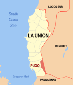 Map of La Union with Pugo highlighted | |

| |
.svg.png) Pugo Location within the Philippines | |
| Coordinates: 16°17′N 120°29′E | |
| Country | |
| Region | Ilocos Region (Region I) |
| Province | La Union |
| District | 2nd District |
| Founded | 1912 |
| Barangays | 14 (see Barangays) |
| Government | |
| • Type | Sangguniang Bayan |
| • Mayor | Priscilla M. Martin |
| • Vice Mayor | Jose B. Basallo |
| • Congressman | Sandra Y. Eriguel |
| • Electorate | 12,275 voters (2019) |
| Area | |
| • Total | 62.84 km2 (24.26 sq mi) |
| Elevation | 65.5 m (214.9 ft) |
| Population (2015 census)[3] | |
| • Total | 19,690 |
| • Density | 310/km2 (810/sq mi) |
| • Households | 4,347 |
| Economy | |
| • Income class | 5th municipal income class |
| • Poverty incidence | 5.83% (2015)[4] |
| • Revenue (₱) | |
| • Assets (₱) | |
| • Expenditure (₱) | |
| Time zone | UTC+8 (PST) |
| ZIP code | 2508 |
| PSGC | |
| IDD : area code | +63 (0)72 |
| Climate type | tropical monsoon climate |
| Native languages | Ilocano Pangasinan Tagalog |
| Website | www |
Pugo is located at the foot of the Santo Tomas mountain range, just 36 kilometres (22 mi) west from Baguio City via the Marcos Highway. Pugo is 16 kilometres (9.9 mi) from Agoo and 50 kilometres (31 mi) from the provincial capital San Fernando. It is primarily an agricultural town.
Climate
| Climate data for Pugo, La Union | |||||||||||||
|---|---|---|---|---|---|---|---|---|---|---|---|---|---|
| Month | Jan | Feb | Mar | Apr | May | Jun | Jul | Aug | Sep | Oct | Nov | Dec | Year |
| Average high °C (°F) | 30 (86) |
31 (88) |
32 (90) |
33 (91) |
32 (90) |
31 (88) |
30 (86) |
29 (84) |
30 (86) |
30 (86) |
31 (88) |
30 (86) |
31 (87) |
| Average low °C (°F) | 20 (68) |
21 (70) |
22 (72) |
24 (75) |
25 (77) |
25 (77) |
24 (75) |
24 (75) |
24 (75) |
23 (73) |
22 (72) |
20 (68) |
23 (73) |
| Average precipitation mm (inches) | 15 (0.6) |
16 (0.6) |
24 (0.9) |
33 (1.3) |
102 (4.0) |
121 (4.8) |
177 (7.0) |
165 (6.5) |
144 (5.7) |
170 (6.7) |
56 (2.2) |
23 (0.9) |
1,046 (41.2) |
| Average rainy days | 6.3 | 6.6 | 9.5 | 12.8 | 20.6 | 23.5 | 25.4 | 23.4 | 23.2 | 21.4 | 14.0 | 8.2 | 194.9 |
| Source: Meteoblue [5] | |||||||||||||
History
The name of Pugo has its origin from Pangasinan, a language used in Pangasinan, a province south of La Union. Pugo as well as other parts of southern La Union was once part of the ethno-linguistic territory of Pangasinan-speaking people prior to political subdivision during the Spanish regime. Now, only a minority speaks Pangasinan in La Union mainly in the towns of Rosario and Santo Tomas. The term "Pugo" which means "islet"; while Pugo itself is not an island, the term describes the huge rockbeds in the Tapuacan River. The river also features rockwalls and huge rocks which are now known as the Tapuakan Resort in Barangay Cares.
Local government
Just as the national government, the municipal government of Pugo is divided into three branches: executive, legislative and judiciary. The judicial branch is administered solely by the Supreme Court of the Philippines. The LGUs have control of the executive and legislative branch.
The executive branch is composed of the mayor and the barangay captain for the barangays.Local Government Code of the Philippines, Book III, Department of Interior and Local Government official website.
The legislative branch is composed of the Sangguniang Bayan (town assembly), Sangguniang Barangay (barangay council), and the Sangguniang Kabataan for the youth sector.
The seat of Government is vested upon the Mayor and other elected officers who hold office at the Pugo Town hall. The Sanguniang Bayan is the center of legislation, stationed in Pugo Legislative Building.
Barangays
| Barangay | Population |
|---|---|
| Ambalite | 887 |
| Ambangonan | 928 |
| Cares | 1,900 |
| Cuenca | 1,713 |
| Duplas | 604 |
| Maoasaoas Norte | 1,212 |
| Maoasaoas Sur | 973 |
| Palina | 1,300 |
| Poblacion East | 875 |
| Poblacion West | 1,024 |
| San Luis | 1,854 |
| Saytan | 1,304 |
| Tavora East | 748 |
| Tavora Proper | 1,196 |
| Total | 16,518 |
Demographics
| Population census of Pugo | ||||||||||||||||||||||||||||||||||||||||||||||
|---|---|---|---|---|---|---|---|---|---|---|---|---|---|---|---|---|---|---|---|---|---|---|---|---|---|---|---|---|---|---|---|---|---|---|---|---|---|---|---|---|---|---|---|---|---|---|
|
| |||||||||||||||||||||||||||||||||||||||||||||
| Source: Philippine Statistics Authority[3][7][8][9] | ||||||||||||||||||||||||||||||||||||||||||||||
In the 2015 census, the population of Pugo, La Union, was 19,690 people,[3] with a density of 310 inhabitants per square kilometre or 800 inhabitants per square mile.
Tourist destinations


Nature and Man Made Adventure
With the opening of the PUGAD Pugo Adventure Park in Sitio Kagaling of Barangay Palina, the town now offers extreme adventure. It offers 3 Zip Lines with its famous 380 meters long 200 feet high Super Man Zip Line 1. It also has Swimming Pools, Cottages, Conference Halls, Hanging Bridge, Clean River, Rappeling Area, Wall Climbing, Ropping, ATV Rides, Paint Ball Area, Trekking, and view of the Water Falls.
10 minutes away from Pugad Pugo Adventure is the "Travellers Inn". It offers villas, rooms, and even water adventure parks.
Scenic spots in Pugo include Tapuakan Resort, the Nagbukel and the hot springs of Cares. Tapuakan Resort features rest areas where the people can enjoy the natural slides of the river. It was recently awarded as the clearest inland body of water for 2008 making it for 2 consecutive years. It also has a hot spring where tourists and the Pugonians go often as they believe that the spring can heal certain skin and pulmonary diseases. Nagbukel is found at Barangay Ambangonan, and many people also go there despite its remote location.
PUGAD
PUGAD (bird’s nest) is one of the recreation and adventure landmarks in Pugo. It is a picturesque site with 3 hectares of green forests, lush mountain and clean river. It is 300 meters away from Marcos Highway.[10]
- Zip Line Adventure - Pugo's Pugad has the longest zip line (380 meters) in Luzon, the second in the Philippines.
Tapuacan River
Tapuacan River (also known as Pugo - Cleanest Inland River of the North, Region I) is located in Barangay Cares (the smallest/inlet town which is situated at the foot of the Santo Tomas mountains range and about an hour away from Baguio City passing through the Aspiras, formerly Marcos Highway leading to the Ilocandia Region). The natural scenery is also a 1-hour ride from San Fernando City and around 4–5 hours drive from Manila.
Kultura Splash Wave
Pugo's Kultura Splash Wave is a prime resort[11] (Km. 21 Marcos Highway, Barangay Cares). It has attraction: Lap pool, Pool Kiddie, Dolphin pools, 4 Giant Slides with Dropzone, Water Factory, Aerial Zip Lines, Wall Climbing, Sky Walker.
Marcos bust
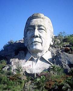
A 30 m (98 ft) concrete Bust of Ferdinand Marcos built from 1978 to 1980 using government funds. The monument was controversial as the land used were grabbed from the indigenous Ibaloi people, who were against the Marcos conjugal dictatorship. The monument was built upon the orders of then incumbent President Ferdinand Marcos in a park that he named after himself. The park's land was also land-grabbed from the Ibaloi people. The monument was destroyed in December 2002 by treasure hunters.[12] The destroyed bust is considered "a monument to evil, warning people never to become what this man was".[13]
Holy Family Family Parish Church
As of 2012, the 1909 Holy Family Family Parish Church of Pugo (canonically erected in 1909), celebrates its fiesta every Last Sunday of December. It is under the jurisdiction of the Roman Catholic Diocese of San Fernando de La Union (Dioecesis Ferdinandopolitana ab Unione, Suffragan of Lingayen – Dagupan, which was created on January 19, 1970 and erected on April 11, 1970, comprising the Civil Province of La Union, under the Titular, St. William the Hermit, February 10). The heritage church is under a diocese of the Latin Rite of the Roman Catholic Church in the Philippines from the Archdiocese of Nueva Segovia. Its Parish Priest is Fr. Crispin N. Reyes.[14]
The Pugo Church is under the Vicariate of St. Francis Xavier with Vicar Forane, Fr. Joel Angelo Licos.[15][16] The Holy Family Parish was built in the year 1909-1911 by the Belgian Missionary for the people of Pugo, La Union.
Gallery
 Town center and welcome arch
 Municipal hall
 Town plaza
 Pugo rural landscape

References
- "Municipality". Quezon City, Philippines: Department of the Interior and Local Government. Retrieved 31 May 2013.
- "Province: La Union". PSGC Interactive. Quezon City, Philippines: Philippine Statistics Authority. Retrieved 12 November 2016.
- Census of Population (2015). "Region I (Ilocos Region)". Total Population by Province, City, Municipality and Barangay. PSA. Retrieved 20 June 2016.
- "PSA releases the 2015 Municipal and City Level Poverty Estimates". Quezon City, Philippines. Retrieved 1 January 2020.
- "Pugo: Average Temperatures and Rainfall". Meteoblue. Retrieved 26 April 2020.
- "2010 Census of Population and Housing: Population Counts - Cordillera Administrative Region" (PDF). Philippine Statistics Authority. April 4, 2012. Archived from the original (PDF) on 26 June 2015. Retrieved 16 November 2014.
- Census of Population and Housing (2010). "Region I (Ilocos Region)". Total Population by Province, City, Municipality and Barangay. NSO. Retrieved 29 June 2016.
- Censuses of Population (1903–2007). "Region I (Ilocos Region)". Table 1. Population Enumerated in Various Censuses by Province/Highly Urbanized City: 1903 to 2007. NSO.
- "Province of La Union". Municipality Population Data. Local Water Utilities Administration Research Division. Retrieved 17 December 2016.
- "PUGAD: A nest of recreation and adventure in Pugo La Union". Tarabitab. 2 October 2010. Archived from the original on 26 June 2012. Retrieved 28 September 2014.
- http://kulturasplashwave.com/
- Dumlao, Artemio (2002-12-30). "Marcos bust blasted". The Philippine Star. Retrieved 2019-02-05.
- "Archbishop decries Marcos bust bombing, Communists take credit". UCA News. 31 December 2002. Retrieved 27 February 2015.
- http://wikimapia.org/2052515/Holy-Family-Parish-Church
- http://www.claretianpublications.com/index.php?option=com_content&view=article&id=557:diocese-of-san-fernando-de-la-union&catid=4&Itemid=140
- Catholic-Hierarchy
External links
| Wikimedia Commons has media related to Pugo, La Union. |
- Pugo Profile at PhilAtlas.com
- Pasyalan La Union
- Philippine Standard Geographic Code
- Philippine Census Information
- Local Governance Performance Management System
Places adjacent to Pugo, La Union | ||||||||||
|---|---|---|---|---|---|---|---|---|---|---|
| ||||||||||