Cities and towns in West Bengal
West Bengal is the state with highest population density in India.[1] The state is dotted with several small and medium towns and cities. Historically, the main source of income of the people of West Bengal has been farming, and, as a consequence, the state previously had a large rural population skew. At the turn of the 20th century, however, the role of industry in West Bengal increased substantially, leading to a population move into urban areas.
_and_Strand_Road%2C_Calcutta_in_1945.jpg)
In 1947, when India gained independence, the erstwhile British Indian province of Bengal was divided into two parts: the eastern region formed East Pakistan—which became Bangladesh in 1971 — and the western part joined India as the state of West Bengal. Scores of refugees from the eastern part came to West Bengal, leading to the start of new urban areas, and contributing to the congestion of already established cities like Kolkata.
Current scenario
As of 2011 India census,[2] 375 cities and towns in West Bengal can be classified in the following categories:
- 6 Urban agglomerations (UA): Kolkata (Kolkata Municipal Corporation is responsible for civic administration of the city, whereas Kolkata Metropolitan Development Authority is responsible for Greater Kolkata, the UA). Burdwan, Malda, Midnapore-Kharagpur, Siliguri-Jalpaiguri, Asansol-Durgapur form the other UAs.[3]
- 7 Municipal Corporations: Asansol, Bidhannagar, Chandannagar, Durgapur, Howrah, Kolkata, Siliguri.
- 114 Municipalities: Alipurduar, Arambag, Ashoknagar Kalyangarh, Baduria, Baharampur, Baidyabati, Bally (now merged with Howrah Municipal Corporation)[4][5][6][7], Balurghat, Bangaon, Bankura, Bansberia, Baranagar, Barasat, Bardhaman, Barrackpore, Baruipur, Basirhat, Beldanga, Bhadreswar, Bhatpara, Birnagar, Bishnupur, Bolpur, Budge Budge, Buniadpur, Chakdaha, Champdani, Chandrakona, Contai, Dainhat, Dalkhola, Dankuni, Darjeeling, Dhulian, Dhupguri, Diamond Harbour, Dinhata, Domkal, Dubrajpur, Dum Dum, Egra, English Bazar, Gangarampur, Garulia, Gayespur, Ghatal, Gobardanga, Guskara, Habra, Haldia, Haldibari, Halisahar, Hugli-Chuchura, Haringhata, Islampur, Jalpaiguri, Jangipur, Jaynagar Majilpur, Jhalda, Jhargram, Jiaganj Azimganj, Kaliaganj, Kalimpong, Kalna, Kalyani, Kamarhati, Kanchrapara, Kandi, Katwa, Kharagpur, Kharar, Khardaha, Koch Bihar, Konnagar, Krishnanagar, Kshirpai, Kurseong, Madhyamgram, Maheshtala, Mal, Mathabhanga, Mekliganj, Memari, Midnapore, Mirik, Murshidabad, Nabadwip, Naihati, Nalhati, New Barrackpur, North Barrackpur, North Dumdum, Old Malda, Panskura, Panihati, Pujali, Puruliya, Raghunathpur, Raiganj, Rajarhat-Gopalpur (now merged with Bidhannagar Municipal Corporation)[8][9], Rajpur Sonarpur, Ramjibanpur, Rampurhat, Ranaghat, Rishra, Sainthia, Santipur, Serampore, Sonamukhi, South Dumdum, Suri, Taki, Tamluk, Tarakeswar, Titagarh, Tufanganj, Uluberia and Uttarpara Kotrung.
- 2 Notified Areas: Cooper's Camp and Taherpur
- 1 Cantonment Board: Barrackpur Cantonment
- 782 Census Towns.
Major cities


| Name | Coordinates | Area[12] | Status[12] | Population 2011[14] | Population Density | Importance |
|---|---|---|---|---|---|---|
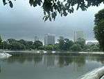
| Kolkata | 22.57°N 88.37°E | 206.08 km2 (79.57 sq mi)[15] | Municipal Corporation | 4496694[16][17] | 21,935/km2 (56,810/sq mi) | The capital of West Bengal. It was the capital of British India until 1911. Kolkata is one of the four big cities in India, and is one of the largest urban agglomerations in the world. |
| Howrah | 22.59°N 88.31°E | 63.55 km2 (24.54 sq mi)[18][19] | Municipal Corporation | 1370448[20][21] | 21,565/km2 (55,850/sq mi) | A primarily industrial city in West Bengal, located on the west bank of the Hooghly River, and is the twin city to Kolkata. Headquarter of the Howrah district. |
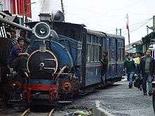
| Darjeeling | 27.03°N 88.16°E | 10.57 km2 (4.08 sq mi) | Municipality | 107530 | 10,173/km2 (26,350/sq mi) | It is a famous hill station and tourist destination. Also known for its access route, the Darjeeling Himalayan Railway, Darjeeling tea, and historical role of the city as a summer retreat. Headquarter of the Darjeeling district. |
| Kalimpong | 27.06°N 88.47°E | 8.67 km2 (3.35 sq mi) | Municipality | 42980 | 4,957/km2 (12,840/sq mi) | It is a hill station in the Kalimpong district. It is known as a tourist destination, especially for its climate, and for its Buddhist monasteries and flower market. |
| Sainthia | 23.92°N 87.53°E | 16 km2 (6.2 sq mi) | Municipality | 44601 | 4,400/km2 (11,000/sq mi) | One of the busiest business hubs in West Bengal and business capital of the Birbhum district. From the city, the agricultural products are exported to different parts of the State and also to different parts of the Eastern India. It is a famous tourist destination. The Famous Nandikeshwari Temple, which is one of the Shakti Peethas of Indian subcontinent situated in this city.[22] |
| Bolpur | 23.67°N 87.69°E | 17.70 km2 (6.83 sq mi) | Municipality | 80,210 | 4,532/km2 (11,740/sq mi) | Situated on bank of River Ajay, West Bengal ,it is educational capital of the Birbhum district. It hosts Viswa Bharati University VBU which was founded by Tagore. It is a famous tourist destination. It arranges its own version of Colors of Holi attracts people from all over. |
| Kharagpur | 22.33°N 87.33°E | 90.65 km2 (35.00 sq mi) | Municipality | 207984 | 19,294/km2 (49,970/sq mi) | The fifth largest city of West Bengal (by area) is famous for the Indian Institute of Technology. Also has one of the longest railway platform in the world and a major air force base, Kalaikunda nearby. The railway station is one of the best as well as beautiful in India. It is a major industrial city in West Bengal. |
| Bardhaman | 23.25°N 87.85°E | 48.00 km2 (18.53 sq mi) | Municipality | 346639 | 5,956/km2 (15,430/sq mi) | Headquarters of the Purba Bardhaman district.
Sixth Largest City Of West Bengal. |
| Asansol | 23.68°N 86.98°E | 127.24 km2 (49.13 sq mi) | Municipal Corporation | 1243414 | 4,434/km2 (11,480/sq mi) | Asansol is the second largest city and urban agglomeration in West Bengal after Kolkata. An industrial city in the Paschim Bardhaman district known for the IISCO Steel Plant at Burnpur, the locomotive works at Chittaranjan and the recently founded Kazi Nazrul University. It is at the heart of the Eastern Coalfields area and hosts the headquarters for the mining company. Asansol serves as the commercial hub for the entire region and operates as the Divisional Headquarters for the Asansol Division of the Eastern Railways. |
| Durgapur | 23.48°N 87.32°E | 154.20 km2 (59.54 sq mi) | Municipal Corporation | 580990 | 3,197/km2 (8,280/sq mi) | An industrial city in the Paschim Bardhaman district, famous for the National Institute of Technology, Durgapur and the Central Mechanical Engineering Research Institute, a large industrial city with well-planned roads and townships. It is the second largest city in terms of area. |
| Murshidabad | 24.18°N 88.27°E | 12.95 km2 (5.00 sq mi) | Municipality | 44019 | 12,368/km2 (32,030/sq mi) | It was the capital of Bengal before British Raj. |
| Malda City | 25.00°N 88.15°E | 13.25 km2 (5.12 sq mi) | Municipality | 313681 | 12,185/km2 (31,560/sq mi) | Headquarter of Malda district and The fifth largest city in state and second in North Bengal, most important trade hub after Siliguri in North Bengal. It is the gateway of North Bengal as well as north-eastern region of India. It was the capital of ancient Bengal from the 5th century BC till the time of Muslim rule. The relics are found at Gaur and Pandua. |
| Siliguri | 26.71°N 88.43°E | 41.90 km2 (16.18 sq mi) | Municipal Corporation | 705579 | 11,224/km2 (29,070/sq mi) | An arterial city in North Bengal, one of the most important business hubs in the state and the entire north-eastern region of India. It is the fourth largest city of the state and the second most important trade hub after Kolkata. |
| Jalpaiguri | 26.52°N 88.73°E | 12.97 km2 (5.01 sq mi) | Municipality | 169002 | 7,726/km2 (20,010/sq mi) | Headquarters of the Jalpaiguri district. |
| Raiganj | 25.62°N 88.12°E | 8.99 km2 (3.47 sq mi) | Municipality | 199690 | 18,378/km2 (47,600/sq mi) | Headquarters of the district North Dinajpur. |
| Balurghat | 25.22°N 88.77°E | 8.56 km2 (3.31 sq mi) | Municipality | 164816 | 15,831/km2 (41,000/sq mi) | Headquarters of the district South Dinajpur. |
| Purulia | 23.33°N 86.37°E | 13.93 km2 (5.38 sq mi) | Municipality | 126815 | 8,167/km2 (21,150/sq mi) | Headquarters of the Purulia district. |
| Baharampur | 24.1°N 88.25°E | 31.42 km2 (12.13 sq mi) | Municipality | 304487 | 5,098/km2 (13,200/sq mi) | Also called Berhampore. It is the headquarters of Murshidabad district. |
| Krishnanagar | 23.4°N 88.5°E | 15.96 km2 (6.16 sq mi) | Municipality | 182010 | 8,714/km2 (22,570/sq mi) | Headquarters of the Nadia district. |
| Barasat | 22.23°N 88.45°E | 34.50 km2 (13.32 sq mi) | Municipality | 287435 | 6,711/km2 (17,380/sq mi) | Headquarters of the North 24 Parganas district. |
| Barrackpore | 22.76°N 88.37°E | 11.65 km2 (4.50 sq mi) | Municipality | 152783 | 12,396/km2 (32,110/sq mi) | The first army barrack of the British East India Company was established here. Also, the first sparks of 1857 Indian mutiny is said to have started from this city. It is now a northern suburb of Kolkata. |
| Ranaghat | 23.18°N 88.58°E | 7.72 km2 (2.98 sq mi) | Municipality | 234449 | 8,906/km2 (23,070/sq mi) | It is one of the important rail stations in eastern railway and a communication link between north and south Bengal, also a growing market. |
| Baranagar | 22.64°N 88.37°E | 7.12 km2 (2.75 sq mi)[23] | Municipality[24] | 2,45,313[25] | 34,454/km2 (89,240/sq mi)[25] | The city was originally a Portuguese settlement that become the seat of Dutch trading station and an important river anchorage for Dutch shipping.[26] It houses the Peneti Bagabari of the Tagore family among other historical buildings.[27] |
| Serampore | 22.75°N 88.34°E | 14.50 km2 (5.60 sq mi) | Municipality | 181842 | 13,652/km2 (35,360/sq mi) | A city of the Danish East India Company. |
| Chandannagar | 22.87°N 88.38°E | 20.00 km2 (7.72 sq mi) | Municipal Corporation | 166867 | 8,108/km2 (21,000/sq mi) | A city built by the French East India Company. |
| Chinsura | 22.90°N 88.39°E | 17.29 km2 (6.68 sq mi) | Municipality | 179931 | 9,844/km2 (25,500/sq mi) | Headquarters of the Hooghly district. |
| Kalyani | 22.98°N 88.48°E | 29.14 km2 (11.25 sq mi) | Municipality | 100,575 | 3,500/km2 (9,100/sq mi) | The northernmost part of the Kolkata urban agglomeration, Kalyani was the brainchild of the second chief minister of the state, Dr. Bidhan Chandra Roy. It is a planned township and is divided into residential, industrial and educational sectors. |
| Tamluk | 22.3°N 87.92°E | 10.42 km2 (4.02 sq mi) | Municipality | 65306 | 4,398/km2 (11,390/sq mi) | Headquarters of the district Midnapore East. |
| Medinipur | 22.25°N 87.65°E | 18.36 km2 (7.09 sq mi) | Municipality | 169264 | 8,352/km2 (21,630/sq mi) | Headquarters of the district Midnapore West. |
| Nabadwip | 23.25°N 88.22°E | 12 km2 (4.6 sq mi) | Municipality | 125543 | 10,500/km2 (27,000/sq mi) | Nabadwip was capital of old Bengal(A.D. 1169 – A.D.1206). It was a place of culture, literature, religion.Lord Sri Chaityanya was born here making it a holy place for Hindus. |
| Contai | 21.78°N 87.75°E | 14.25 km2 (5.50 sq mi) | Municipality | 92226 | 5,438/km2 (14,080/sq mi) | Near the tourist attraction, Digha. |
| Cooch Behar | 26.19°N 89.26°E | 8.19 km2 (3.16 sq mi) | Municipality | 77935 | 2,053/km2 (5,320/sq mi) | Headquarters of the Cooch Behar district. |
| Bankura | 23.25°N 87.07°E | 19.06 km2 (7.36 sq mi) | Municipality | 137386 | 6,758/km2 (17,500/sq mi) | Headquarters of the Bankura district. |
| Bishnupur | 23.08°N 87.32°E | 22.01 km2 (8.50 sq mi) | Municipality | 67783 | 2,814/km2 (7,290/sq mi) | A city of archeological importance. |
| Haldia | 22.03°N 88.06°E | 109.65 km2 (42.34 sq mi) | Municipality | 200827 | 1,557/km2 (4,030/sq mi) | Most important among upcoming industrial hubs of the state. Home to major petrochemical houses, it is set to become the most important port in the region. |
List of urban areas (district-wise)
References
- 903 per sq. km. "India at a glance: Population Density". Census of India, 2001. Retrieved 13 December 2008.
- "Census of India 2001: Data from the 2001 Census, including cities, villages and towns (Provisional)". Census Commission of India. Archived from the original on 16 June 2004. Retrieved 1 November 2008.
- "List of Million Plus Cities of India". Census of India. Retrieved 14 October 2008.
- "HMC sets up 'Mayor's Cop' to monitor civic amenities". millenniumpost.in.
- Bally battles merger blues telegraphindia.com/
- Merge Bally, Howrah civic bodies: Mamata Banerjee timesofindia.com | 19 May 2015
- "HMC".
- "bmcwbgov.in".
- "Bidhannagar Municipal Corporation is to be formed".
- "Four new municipalities in West Bengal". Rabin Biswas. Retrieved 4 December 2010.
- http://www.north24parganas.nic.in. Missing or empty
|title=(help) - "Category, Year of Establishment, Area, SC, ST and total population in ULBs in West Bengal" (PDF). Department of Municipal affairs, Government of West Bengal. Archived from the original (PDF) on 4 December 2009. Retrieved 9 November 2008.
- "All India Trinamool Congress". www.aitcofficial.org. Retrieved 10 December 2017.
- https://www.citypopulation.de/India-WestBengal.html
- "Basic Statistics of Kolkata". Kolkata Municipal Corporation. Kolkata Municipal Corporation. Archived from the original on 2 April 2015.
- "District Census Handbook – Kolkata" (PDF). Census of India. The Registrar General & Census Commissioner. p. 43. Archived (PDF) from the original on 18 October 2016. Retrieved 13 May 2016.
- "Kolkata Municipal Corporation Demographics". Census of India. Retrieved 3 June 2016.
- "HMC" (PDF).
- "Bally Municipality". Archived from the original on 2 April 2015.
- [Primary Census Abstract Data Tables – West Bengal – DDW_PCA1915_2011_MDDS with UI "Census 2011 Handbook of Howrah"] Check
|url=value (help). - "Bally 2011 census".
- http://m.sainthia.westbengalonline.in/city-guide/about-sainthia#
- "Baranagar Police Station". barrackporecitypolice.in. Retrieved 6 December 2019.
- "Welcome to www.baranagarmunicipality.org". Retrieved 6 December 2019.
- "2011 Census – Primary Census Abstract Data Tables". West Bengal – District-wise. Registrar General and Census Commissioner, India. Retrieved 6 December 2019.
- "Baranagar Municipality - Right to Information Act". Baranagar Municipality. Retrieved 6 December 2019.
- "Initiative to declare cities along the bank of Hooghly as heritage cities". All India Trinamool Congress. 1 October 2015. Retrieved 6 December 2019.
- "List of Census Towns, West Bengal, 2001". Census of India, Directorate of Census Operations, West Bengal. Retrieved 15 December 2008.