Balarampur, Budge Budge
Balarampur is a census town within the jurisdiction of the Budge Budge police station in the Budge Budge I CD block in the Alipore Sadar subdivision of the South 24 Parganas district in the Indian state of West Bengal.
Balarampur | |
|---|---|
Census Town | |
 Balarampur Location in West Bengal  Balarampur Location in India | |
| Coordinates: 22.4744°N 88.2142°E | |
| Country | |
| State | West Bengal |
| District | South 24 Parganas |
| CD block | Budge Budge I |
| Area | |
| • Total | 1.43 km2 (0.55 sq mi) |
| Elevation | 9 m (30 ft) |
| Population (2011) | |
| • Total | 5,251 |
| • Density | 3,700/km2 (9,500/sq mi) |
| Languages | |
| • Official | Bengali[1][2] |
| • Additional official | English[1] |
| Time zone | UTC+5:30 (IST) |
| PIN | 743318 |
| Telephone code | +91 33 |
| Vehicle registration | WB-19 to WB-22, WB-95 to WB-99 |
| Lok Sabha constituency | Diamond Harbour |
| Vidhan Sabha constituency | Budge Budge |
| Website | www |
Geography
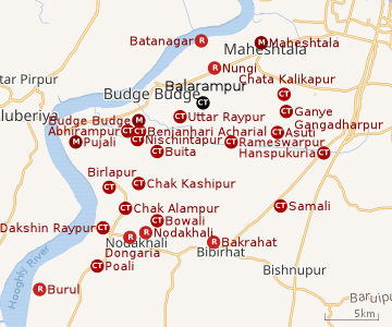 |
| Cities and towns in the western part of Alipore Sadar subdivision (including Budge Budge I & II, Thakurpukur Maheshtala CD blocks) in South 24 Parganas district M: municipal city/ town, CT: census town, R: rural/ urban centre, Owing to space constraints in the small map, the actual locations in a larger map may vary slightly Bakrahat is in Bishnupur II CD block, but Lakshmibala Rural Hospital at Bakrahat serves Budge Budge II CD block and so it is included here. |
Area overview
Alipore Sadar subdivision is the most urbanized part of the South 24 Parganas district. 59.85% of the population lives in the urban areas and 40.15% lives in the rural areas. In the northern portion of the subdivision (shown in the map alongside) there are 21 census towns. The entire district is situated in the Ganges Delta and the subdivision, on the east bank of the Hooghly River, is an alluvial stretch, with industrial development.[3][4][5]
Note: The map alongside presents some of the notable locations in the subdivision. All places marked in the map are linked in the larger full screen map.
Location
Balarampur is located at 22.4744°N 88.2142°E. It has an average elevation of 9 metres (30 ft).
Balarampur, Uttar Raypur, Buita, Benjanhari Acharial, Abhirampur and Nischintapur form a cluster of census towns around Budge Budge and Pujali, as per the map of the Budge Budge I CD block on page 167 of the District Census Handbook 2011 for the South 24 Parganas.[6]
Demographics
According to the 2011 Census of India, Balarampur had a total population of 5,251, of which 2,689 (51%) were males and 2,562 (49%) were females. There were 524 people in the age range 0-6 years. The total number of literates was 3,755 (79.44 % of the population over 6 years).[7]
According to the 2001 Census of India, Balarampur had a population of 4,710. Males constitute 51% of the population and females 49%. It has an average literacy rate of 64%, higher than the national average of 59.5%; with 56% of the males and 44% of females literate. 13% of the population is under 6 years of age.[8]
Kolkata Urban Agglomeration
The following municipalities and census towns in the South 24 Parganas district were part of the Kolkata Urban Agglomeration in the 2011 census: Maheshtala (M), Joka (CT), Balarampur (CT), Chata Kalikapur (CT), Budge Budge (M), Nischintapur (CT), Uttar Raypur (CT), Pujali (M) and Rajpur Sonarpur (M).[9]
Infrastructure
According to the District Census Handbook 2011, Balarampur covered an area of 1.43 km2. Among the civic amenities it had 8 km of roads. Protected water supply involves hand pumps. It had 491 domestic electric connections. Among the medical facilities it had were 2 dispensaries/ health centre and 3 medicine shops. Among the educational facilities it had were 3 primary schools, 1 middle school, the nearest secondary school and senior secondary school were at Uttar Raypur 1.5 km away. The nearest general degree college was at Budge Budge 8 km away. It had the branch of 1 nationalised bank.[10]
Transport
Nangi railway station on Sealdah–Budge Budge line is 2 km away.
Education
Nandrampur Balarampur Junior High School is a Bengali-medium coeducational institution established in 2009. It has facilities for teaching from class V to class VIII.[11]
Happy Home English School is an English-medium coeducational institution established in 2009. It has facilities for teaching from class I to class X. [12]
Maheshtala High School is a Bengali-medium coeducational institution established in 1858. It has facilities for teaching from class V to class XII.[13]
Healthcare
Benjanhari Acharial Rural Hospital at Benjanhari Acharial with 30 beds is the major government medical facility in the Budge Budge I CD block.[14]
References
- "Fact and Figures". Wb.gov.in. Retrieved 5 July 2019.
- "52nd REPORT OF THE COMMISSIONER FOR LINGUISTIC MINORITIES IN INDIA" (PDF). Nclm.nic.in. Ministry of Minority Affairs. p. 85. Archived from the original (PDF) on 25 May 2017. Retrieved 5 July 2019.
- "District Statistical Handbook 2014 South Twety-four Parganas". Table 2.1 , 2.2, 2.4b. Department of Statistics and Programme Implementation, Government of West Bengal. Archived from the original on 21 January 2019. Retrieved 5 December 2019.
- "Census of India 2011, West Bengal, District Census Handbook, South Twentyfour Parganas, Series – 20, Part XII-A, Village and Town Directory" (PDF). Page 13, Physiography. Directorate of Census Operations, West Bengal. Retrieved 5 December 2019.
- "District Human Development Report: South 24 Parganas". Chapter 9: Sundarbans and the Remote Islanders, p 290-311. Development & Planning Department, Government of West Bengal, 2009. Archived from the original on 5 October 2016. Retrieved 5 December 2019.
- "District Census Handbook South Twentyfour Parganas, Census of India 2011, Series 20, Part XII A" (PDF). Page 167 – Map of Budge Budge I CD block. Directorate of Census Operations, West Bengal. Retrieved 24 September 2019.
- "C.D. Block Wise Primary Census Abstract Data(PCA)". 2011 census: West Bengal – District-wise CD Blocks. Registrar General and Census Commissioner, India. Retrieved 26 April 2016.
- "Census of India 2001: Data from the 2001 Census, including cities, villages and towns (Provisional)". Census Commission of India. Archived from the original on 16 June 2004. Retrieved 1 November 2008.
- "Provisional Population Totals, Census of India 2011" (PDF). Constituents of Urban Agglomeration Having Population Above 1 Lakh. Census of India 2011. Retrieved 7 November 2019.
- "District Census Handbook South Twenty Four Parganas, Census of India 2011, Series 20, Part XII A" (PDF). Section II Town Directory, Pages 999-1006 Statement I: Status and Growth History, Pages 1006-1010; Statement II: Physical Aspects and Location of Towns, Pages 1010-1015; Statement III: Civic and other Amenities, Pages 1015-1019; Statement IV: Medical Facilities 2009, Pages 1019-1027 Statement V: Educational, Recreational and Cultural Facilities, Pages 1027- 1029: Statement VI:Industry and Banking. Directorate of Census Operations V, West Bengal. Retrieved 9 November 2018.
- "Nandrampur Balarampur Junior High School". ICBSE. Retrieved 11 December 2019.
- "Happy Home English School". EduGorilla. Retrieved 11 December 2019.
- "Maheshtala High School". ICBSE. Retrieved 11 December 2019.
- "Health & Family Welfare Department" (PDF). Health Statistics – Rural Hospitals. Government of West Bengal. Retrieved 8 January 2020.
| Kolkata Municipal Corporation |
|
|---|---|
| Kolkata Urban Agglomeration Outside KMC |
|
| |