Salap
Salap is a census town in Domjur CD Block of Howrah Sadar subdivision in Howrah district in the Indian state of West Bengal. It is a part of Kolkata Urban Agglomeration.[1]
Salap | |
|---|---|
Census Town | |
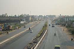 National Highway 16/ Asian Highway 45, Salap | |
 Salap Location in West Bengal, India  Salap Salap (India) | |
| Coordinates: 22.61°N 88.27°E | |
| Country | |
| State | West Bengal |
| District | Howrah |
| Population (2011) | |
| • Total | 15,171 |
| Languages | |
| • Official | Bengali, English |
| Time zone | UTC+5:30 (IST) |
| Vehicle registration | WB |
| Lok Sabha constituency | Sreerampur |
| Vidhan Sabha constituency | Domjur |
| Website | howrah |
Demographics
As per 2011 Census of India Salap had a total population of 15,171 of which 7,826 (52%) were males and 7,345 (48%) were females. Population below 6 years was 1,413. The total number of literates in Salap was 11,830 (85.99% of the population over 6 years).[3]
Salap was part of Kolkata Urban Agglomeration in 2011 census.[4]
As of 2001 India census,[5] Salap had a population of 11,759. Males constitute 52% of the population and females 48%. Salap has an average literacy rate of 75%, higher than the national average of 59.5%: male literacy is 80% and female literacy is 69%. In Salap, 11% of the population is under 6 years of age.
Transport
Salap is the junction of National Highway 16 (part of Asian Highway 45) and Makardaha Road (part of State Highway 15). People can easily go to several areas of Kolkata, Howrah and Hooghly from here.
Bus
Private Bus
- 40 Birshibpur - Serampore
- 63 Domjur - Howrah Station
- 79 Panchla - Dunlop
- E43 Dihibhursut - Howrah Station
- E44 Rampur - Howrah Station
- E53 Narit - Howrah Station
- K11 Domjur - Rabindra Sadan
- L3 Jhikhira/Muchighata - Howrah Station
Mini Bus
CTC Bus
Many Shuttle Buses (Without Numbers) also pass through Salap.
Train
Dansi railway station is the nearest railway station on Howrah-Amta line.
References
- "District-wise list of stautory towns". Census Commission of India. Archived from the original on 30 September 2007. Retrieved 28 January 2009.
- "Yahoo maps of Salap". Yahoo maps. Retrieved 29 November 2008.
- "C.D. Block Wise Primary Census Abstract Data(PCA)". 2011 census: West Bengal – District-wise CD Blocks. Registrar General and Census Commissioner, India. Retrieved 11 May 2016.
- "Provisional Population Totals, Census of India 2011" (PDF). Constituents of Urban Agglomeration Having Population Above 1 Lakh. Census of India 2011. Retrieved 11 May 2016.
- "Census of India 2001: Data from the 2001 Census, including cities, villages and towns (Provisional)". Census Commission of India. Archived from the original on 16 June 2004. Retrieved 1 November 2008.
Cities, towns and locations in Howrah District | |
|---|---|
| Cities, municipal and census towns | |
| Locations other than cities and towns | |
| Related topics |
|