Bowali
Bowali is a census town within the jurisdiction of the Nodakhali police station in the Budge Budge II CD block in the Alipore Sadar subdivision of the South 24 Parganas district in the Indian state of West Bengal.
Bowali | |
|---|---|
Census Town | |
 Gopinath Navaratna Temple | |
 Bowali Location in West Bengal  Bowali Location in India | |
| Coordinates: 22.4041°N 88.1852°E | |
| Country | |
| State | West Bengal |
| District | South 24 Parganas |
| CD block | Budge Budge II |
| Area | |
| • Total | 3.62 km2 (1.40 sq mi) |
| Elevation | 9 m (30 ft) |
| Population (2011) | |
| • Total | 10,968 |
| • Density | 3,000/km2 (7,800/sq mi) |
| Languages | |
| • Official | Bengali[1][2] |
| • Additional official | English[1] |
| Time zone | UTC+5:30 (IST) |
| PIN | 743384 |
| Telephone code | +91 33 |
| Vehicle registration | WB-19 to WB-22, WB-95 to WB-99 |
| Lok Sabha constituency | Diamond Harbour |
| Vidhan Sabha constituency | Budge Budge |
| Website | www |
History
The Mondals, the zamindars of Bowali, originally carried the title of Roy/ Rai. Shovaram was awarded the title of Mondal. Shovaram’s grandson, Rajaram, received the zamindari rights of 50 villages (including Budge Budge and Bowali), as a reward for his bravery, from the Raja of Hijli. They settled at Bowali around 1710. Rajaram’s grandson Haradhan, who enjoyed the patronage of the East India Company, and his sons built many temples in Bowali.[3]
Geography
 |
| Cities and towns in the western part of Alipore Sadar subdivision (including Budge Budge I & II, Thakurpukur Maheshtala CD blocks) in South 24 Parganas district M: municipal city/ town, CT: census town, R: rural/ urban centre, Owing to space constraints in the small map, the actual locations in a larger map may vary slightly Bakrahat is in Bishnupur II CD block, but Lakshmibala Rural Hospital at Bakrahat serves Budge Budge II CD block and so it is included here. |
Area overview
Alipore Sadar subdivision is the most urbanized part of the South 24 Parganas district. 59.85% of the population lives in the urban areas and 40.15% lives in the rural areas. In the northern portion of the subdivision (shown in the map alongside) there are 21 census towns. The entire district is situated in the Ganges Delta and the subdivision, on the east bank of the Hooghly River, is an alluvial stretch, with industrial development.[4][5][6]
Note: The map alongside presents some of the notable locations in the subdivision. All places marked in the map are linked in the larger full screen map.
Location
Bowali is located at 22°24′15″N 88°11′07″E. It has an average elevation of 9 metres (30 ft).
Bowali, Chak Kashipur, Chak Alampur, Dakshin Raypur and Poali form a cluster of census towns, as per the map of the Budge Budge II CD block on page 181 of the District Census Handbook 2011 for the South 24 Parganas.[7]
Demographics
According to the 2011 Census of India, Bowali had a total population of 10,968, of which 5,709 (52%) were males and 5,259 (48%) were females. There were 894 people in the age range of 0 to 6 years. The total number of literate people was 8,694 (86.30 % of the population over 6 years).[8]
According to the 2001 Census of India, Bowali had a population of 10,200. Males constitute 53% of the population and females 47%. It has an average literacy rate of 76%, higher than the national average of 59.5%; with male literacy of 83% and female literacy of 69%. 9% of the population is under 6 years of age.[9]
Infrastructure
According to the District Census Handbook 2011, Bowali covered an area of 3.62 km2. Among the civic amenities, the water supply involved over-head tank. It had 2,235 domestic electric connections. Among the educational facilities it had were 5 primary schools, 2 middle schools and 2 secondary schools.[10]
Transport
K.P. Mondal Road, which runs from Budge Budge to Bakrahat, is the artery of Bowali. It is also connected to Nodakhali via Bowali-Rania Road.[13]
Private Bus
- SD76A Amtala - Budge Budge railway station
Education
Bawali High School is a Bengali-medium coeducational institution, established in 1899. It has arrangements for teaching from class V to class XII.[14]
Bawali Pallimongal High School is a Bengali-medium coeducational institution established in 1974. It has facilities for teaching from class VI to class XII.[15]
Bowali picture gallery
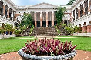 The 300-year old Bowali Rajbari, with Corinthian pillars - it has been renovated for use as a hotel
References
- "Fact and Figures". Wb.gov.in. Retrieved 5 July 2019.
- "52nd REPORT OF THE COMMISSIONER FOR LINGUISTIC MINORITIES IN INDIA" (PDF). Nclm.nic.in. Ministry of Minority Affairs. p. 85. Archived from the original (PDF) on 25 May 2017. Retrieved 5 July 2019.
- Datta, Rangan. "Next weekend you can be at Bawali". Published in The Telegraph. Retrieved 10 November 2019.
- "District Statistical Handbook 2014 South Twety-four Parganas". Table 2.1 , 2.2, 2.4b. Department of Statistics and Programme Implementation, Government of West Bengal. Retrieved 5 December 2019.
- "Census of India 2011, West Bengal, District Census Handbook, South Twentyfour Parganas, Series – 20, Part XII-A, Village and Town Directory" (PDF). Page 13, Physiography. Directorate of Census Operations, West Bengal. Retrieved 5 December 2019.
- "District Human Development Report: South 24 Parganas". Chapter 9: Sundarbans and the Remote Islanders, p 290-311. Development & Planning Department, Government of West Bengal, 2009. Archived from the original on 5 October 2016. Retrieved 5 December 2019.
- "District Census Handbook South Twentyfour Parganas, Census of India 2011, Series 20, Part XII A" (PDF). Page 181 – Map of Budge Budge II CD block. Directorate of Census Operations, West Bengal. Retrieved 2 November 2019.
- "CD block Wise Primary Census Abstract Data(PCA)". 2011 census: West Bengal – District-wise CD blocks. Registrar General and Census Commissioner, India. Retrieved 26 April 2016.
- "Census of India 2001: Data from the 2001 Census, including cities, villages and towns (Provisional)". Census Commission of India. Archived from the original on 16 June 2004. Retrieved 1 November 2008.
- "District Census Handbook South Twenty Four Parganas, Census of India 2011, Series 20, Part XII A" (PDF). Section II Town Directory, Pages 999-1006 Statement I: Status and Growth History, Pages 1006-1010; Statement II: Physical Aspects and Location of Towns, Pages 1010-1015; Statement III: Civic and other Amenities, Pages 1015-1019; Statement IV: Medical Facilities 2009, Pages 1019-1027 Statement V: Educational, Recreational and Cultural Facilities, Pages 1027- 1029: Statement VI:Industry and Banking. Directorate of Census Operations V, West Bengal. Retrieved 9 November 2018.
- "The Rajbari Bawali". TRB. Retrieved 9 December 2019.
- "Bawali Farhouse". BF. Retrieved 9 December 2019.
- Google maps
- "Bawali High School". ICBSE. Retrieved 2 November 2019.
- "Bawali Pallimongal High School". EduGorilla. Retrieved 9 December 2019.