Jhargram district
Jhargram is a district in the state of West Bengal, India.The district lies between the Kangsabati River in the north and the Subarnarekha in the south. Jhargram has one of the lowest population density among the districts of West Bengal,the rural population being higher than the urban. It is a popular tourist destination known for its sal forests, elephants,ancient temples and royal palaces.[1] The district was formed on 4 April 2017, after bifurcation from the Paschim Medinipur district as the 22nd district of West Bengal.[2] The district has its headquarters at Jhargram town.
Jhargram district | |
|---|---|
District of West Bengal | |
 | |
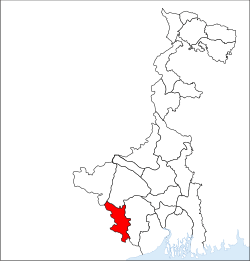 Location of Jhargram district in West Bengal | |
| Country | India |
| State | West Bengal |
| Division | Medinipur division |
| Headquarters | Jhargram |
| Government | |
| • Lok Sabha constituencies | Jhargram |
| • Vidhan Sabha constituencies | Jhargram, Gopiballavpur, Nayagram, Binpur |
| Area | |
| • Total | 3,037.64 km2 (1,172.84 sq mi) |
| Population (2011) | |
| • Total | 1,136,548 |
| • Density | 370/km2 (970/sq mi) |
| • Urban | 61,712 |
| Demographics | |
| • Literacy | 89.2% |
| Time zone | UTC+05:30 (IST) |
| Major highways | Asian Highway 46, SH 5, SH 9, NH 6 (Bombay Road) |
| Website | https://jhargram.gov.in |
Demographics
Jhargram district had a population of 1,136,548 in the 2011 census. 96.52% of the total population was rural and only 3.48% was urban population. 20.11% of the total population belonged to Scheduled Castes and 29.37% belonged to Scheduled Tribes.[3]
Geography
Jhargram district covers an area of 3037.64 Sq. km. Out of which 268249 hectare is agricultural land and 59497 hectare is under forest coverage.The district is a part of Chota Nagpur Plateau which gradually slopes down towards east,hilly terrain occurs in the north-western part of the district. Kakrajhore area is having the highest altitude of about 300 mts. This area is covered with unfertile hard laterite soil/rocks. The altitude of southern areas of the district belonging to Nayagram, Gopiballavpur-I & II blocks are having the altitude of about 65 mts,the soil is comparatively alluvial in these areas. The altitude of Jhargram town is around 80 mts. [4]
Rainfall
The average annual rainfall of Jhargram (Jhargram Forest Division) is about 1400 mm. The rainy season spreads over June to September due to southwest monsoon and the highest rainfall occurs in July and August. The rainfall starts decreasing from October and dry winter sets in. The dry season lasts until May. However, during this time this division gets some sporadic showers.
| Climate data for Jhargram, India | |||||||||||||
|---|---|---|---|---|---|---|---|---|---|---|---|---|---|
| Month | Jan | Feb | Mar | Apr | May | Jun | Jul | Aug | Sep | Oct | Nov | Dec | Year |
| Average high °C (°F) | 16 (61) |
21 (70) |
32 (90) |
38 (100) |
39 (102) |
36 (97) |
30 (86) |
30 (86) |
30 (86) |
31 (88) |
19 (66) |
17 (63) |
30 (86) |
| Average low °C (°F) | 5 (41) |
10 (50) |
21 (70) |
25 (77) |
27 (81) |
27 (81) |
23 (73) |
23 (73) |
22 (72) |
21 (70) |
7 (45) |
6 (43) |
22 (72) |
| Average precipitation mm (inches) | 9.8 (0.39) |
8.3 (0.33) |
19.4 (0.76) |
57.7 (2.27) |
74.9 (2.95) |
172.8 (6.80) |
334.9 (13.19) |
332.7 (13.10) |
185.8 (7.31) |
104.5 (4.11) |
8.7 (0.34) |
5.9 (0.23) |
1,007.4 (39.66) |
| Source: Weatherbase[5] | |||||||||||||
Administration
Jhargram district has 10 police stations, 8 community development blocks, 8 panchayat samitis, 79 gram panchayats, lodhasuli gram panchayat on of them, 2,996 mouzas, 2513 inhabited villages, 1 municipality and 1 census town. The single municipality is at Jhargram. The census town is Silda: The only subdivision, Jhargram subdivision, has its headquarters at Jhargram.[6][7] The state Cabinet has given its nod to form 2 more sub-divisions. The three sub-divisions are supposed to be headquartered at Belpahari, Gopiballavpur and Jhargram.[8]
Forests
For scientific management of forests vested in Government under Estate Acquisition Act, 1953, Jhargram Forest under the administrative setup as Jhargram Division erstwhile parent division styled as Midnapur Division was bifurcated into two divisions viz. West Midnapur Division (renamed as Jhargram Division ) with headquarters at Jhargram and East Midnapur Division with headquarters at Midnapur. The West Midnapore Division came into existence on 29.01.1954.
Location
Presently the forests of Jhargram Division are situated in the Civil Sub-division of Jhargram of Jhargram District and cover the Civil Blocks viz. Binpur-I (the portion on the West of the Kangsabati river), Binpur-II, Jhargram, Jamboni, Gopiballavpur-I & Gopiballavpur-II and police stations of Belpahari, Binpur, Jamboni, Jhargram, Gopiballavpurand Beliyabera. The Jhargram Forest Division lies between 21°-52' and 22°-48' North latitudes and 86°-34' and 87°-20' East longitude approximately. On the North, it is bordered by the civil districts of Purulia and Bankura and on the East, it is bordered by the river Kangsabati (from the western border of Midnapore Division) and partly by the river Subarnarekha from the western border of Kharagpur Division. It is having common borders with the State of Orissa on the Southand in the West with the Jharkhand State.
The headquarters of this Division is Jhargram which is around 15 km away from the AH46 (previously known as National Highway-6) and is situated on the Kolkata-Bombay main line of the South-Eastern Railway. The city is also the headquarters of Jhargram District. The distance of Jhargram from Kolkata is approximately 170 km.
History
In southwest Bengal (including the forests of erstwhile West Midnapore Division), history of forest and its management can be traced to the 16th century when forests were free for use by local villagers for household purposes and cleaning for cultivation. During the Mughal period under land revenue system introduced by Todar Mal, local zamindars had to pay "Ruba" or ¼ th share of revenue to Mughal Emperors for the protection being given by them. In 1773 East India Company went for the permanent settlement of forests (and the landed properties) with zamindars as proprietor. During 1890-1905 Bengal-Nagpur Railways opened railway lines (which helped the transport of forest produces to far off places with ease and less cost) and this followed by two world wars took a heavy toll of forest resources.
The forests of this division were included in Jungle Mahal which was held by zamindars (local chiefs) who maintained their respective forests in a feudal tenure system. With the coming up of Bengal-Nagpur Railway lines from Kharagpur to Jamshedpur Via Jhargram, the forests of this area became accessible. The value of forest produces suddenly increased as they could be transported to far off places by rail with less cost and in quick time. The forests came to be recognized as a source of earning a higher return to the zamindars. The forests of this division were mostly owned by the Nawab of Murshidabad, the Raja of Mayurbhanj, the Raja of Jhargram, the Raja of Chilkigarh and the Mindapore Zamindar company etc. The forests were in advanced stage of degradation brought about by ruthless exploitation by the Zamindars on a rotation of 4–5 years. This system of management (mismanagement) of forests continued till 1948 when the Government of West Bengal started exercising control over the management of forests under the West Bengal Private Forests Act, 1948. But the situation did not improve much.
In 1953 Estates Acquisition Act came into force and the forests so long owned by private owners (big Zamindars) were vested to the government since 1954-55 and afterward were free from all encumbrances for scientific management and control. Subsequently, possession of the forests was being taken by the Forest Department gradually depending upon the availability of records, evidence, and Court's Orders.
After the State (Govt.) took over, the forests were brought under scientific management. However, by this time, the productivity of the forests had gone down to such a level that they could not meet the growing demands of forest produces from ever-increasing population of fringe areas and the county as a whole. The problem was further multiplied due to growing unemployment in the forest fringe villagers and lack of enough resources in the rural areas to tide over the situation.
Administrative measures and policing efforts to thwart the biotic pressures on the forests only resulted in increased people-forester conflict and led to complete alienation of the fringe population from the administration. The job of protection of forests became hazardous. The administration had almost failed to tackle the situation and had been looking for some solution.
A pilot project was launched in 1971-72 by the then Divisional Forest Officer, Silviculture(South) Division at Arabari of East Midnapore Division. The objective was to involve the people living on the fringes of forests, in protecting forest resources through improvement of their socio-economic condition.
During 1985-86 the pilot project was reviewed, evaluated and analyzed. It appeared that the entire project area had become restocked with nearly 700 ha of sal coppice forests and 300 ha of plantation crop. In fact, this pilot project proved to be a success.
This formula of involvement of indigenous people in forest protection and management was translated in other areas including West Midnapore Division since mid-eighties very successfully. Govt. gave recognition to this system of management of forests (popularly termed as Joint Forest Management) by issuing a Govt. Order during 1989 and amendments during 1990 and 1991. Presently this division is having nearly 480 Forest Protection Committees. On and from 1 April 2006 the West Midnapore Division has been reorganized and renamed as Jhargram Forest Division. 3 (three) Ranges namely Chandabila, Nayagram, and Kesorekha Ranges have been transferred to Kharagpur Division with all establishments. Therefore, the area of Jhargram Division becomes 620 km2 approximately.
Rivers
The important rivers of this division are the Kangsabati (popularly known as Kasai), the Tarafeni, the Subarnarekha, and the Dulong. Apart from the above rivers, there are several rivulets viz. 'Deb', 'Palpala', Rangium', 'Kupon' etc. Most of the above rivers flow from west to east as the Western side of the division is having higher altitude.
The Kangsabati river
This river enters the division on the north from Bankura district and flows along a tortuous course running to the south and southwest direction and then flows towards east keeping the Midnapore town on the left(north). The river has contracted rapidly below Midnapore and at Kapastikri (about 20 km down below from Midnapore) the river has bifurcated. One course has gone towards the north and finally has drained into the Rupnarayan river while the other course has run towards the south-east and finally has fallen into the Haldi river.
The Tarafeni river
This river originates in the northwest portion of this division near Patagarh in Banspahari Range. It runs towards east within the jurisdiction of Belpahari and Binpur police Stations and finally has fallen into the Kangsabati river.
The Subarnarekha river
This river enters the division on the west from Dhalbhum (Jharkhand State) and passes through the south of the division intersecting the Gopiballavpur Police Station and forming the northern boundary of Nayagram Police Station (Kharagpur Division). On the south of Dantan, it enters the Balasore district of Odisha and finally falls into the Bay of Bengal. The Subarnarekha has a rapid stream with a sandy bed, and its banks are generally high and well defined. In the season of high flood, the river overflows its left bank about 6 km above the point where it leaves Paschim Midnapore district to enter the Balasore district.
The Dulung river
It is the main tributary of the Subarnarekha. It originates in the northwest portion of the division near Dulungdiha (J.L.No. 100, P.S.: Binpur) and runs generally in a southern direction near the western boundary of the division till it enters Jamboni Police Station. While passing through this police station from north to south it is joined by the Kupon river, Banshir Khal, Polpala Khal, Deb river and Putrangi Khal. Thereafter, it enters Gopiballavpur Police Station where its general direction is from west to east and then Sankrail police station where it again runs in a southerly direction and joins the Subarnarekha. [9]
Economy
The main economy of this area is business & cultivation. Some people are government employees, School Teachers and employed in other private sectors.There are many textile and agriculture based industries;tourism is also one of the important factors for the economy of this district.
Education
Jhargram Raj College is a general degree college in Jhargram district.
Culture
Jhargram is the golden treasury of tribal dances. Some of these tribal dances are on the verge of extinction. Chuang, Chang, Chou, Dangrey, Jhumur, Panta, Ranpa, Saharul, Tusu & Bhadu etc. is not only a mere experience of some masterpiece of human creative art, but a fascinating adventure through essential dimensions of a civilization, its collective priorities, the skills of their implementation and the philosophies that inform them.
Besides the tribal culture, the regular Bengali festivals like Durga puja, Saraswati puja, Diwali and Kali pujas are well attended. Other common pujas in the worship of Shitala, Jagaddhatri, Dol purnima, Ratha Yatra, Janmashtami, Bhima Puja, etc. also takes place.
A lot of fairs and carnivals take place in Jhargram. The famous fairs in Jhargram are Jungle Mahal Utsav, Jhargram Mela & Yuva Utsav, Rong Maati Manush, Shrabani Mela, Baishakhi Mela, Milan Mela, boi mela, silpithirtha, dog show, sramik mela, sabala mela.[10]
Tourist Attractions

There are several tourist-attracting places throughout the Sub-Division.
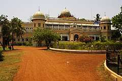
- Jhargram Palace
- Chilkigarh Rajbari, Chilkigarh
- Deer Park (Jungal Mahal zoological Park)
- Savitri Temple
- Rabindra Park
- Chilkigarh Raj Palace
- Kanak Durga Temple
- Jungle Mahal
- Medical Plants Garden (Kalaboni)
- Dherua (for the banks of Kansai river)
- Sevayatan is known for Kechenda Bandh (lake) & surrounding forests
- Tribal Museum
- Alampur
- Kendua (to see migrating birds)
- Kakrajhore Forest
- Rohini: This is a historical village situated on the bank of Dulung River. Birthplace of famous Vaishnav saint Rashikanandaji Maharaj. Now it is visiting spot.
- Gidhni
- Dholkat Pukuria Bharat Sevashram Sangha
- Hatibari Forest Bungalow
- Jhilli Pakhiraloy
- Gopiballavpur Eco Park
- Ghagra Water Falls, Belpahari
Transportation
Air
The nearest operational airport is Netaji Subhash Chandra Bose International Airport of Kolkata 155 km (by train) and 169 km (by road- NH-6).Sonari Airport of Jamshedpur is located at a distance 96 km by train. Birsa Munda Airport of Ranchi is located at a distance of 233 km (by road- NH-33) and 258 km (by train).
Train
Jhargram is connected not only to larger cities in the region, but also to smaller towns and villages in the district. Jhargram Railway Station is on the Kharagpur-Tatanagar section of Howrah-Nagpur-Mumbai line, an express train route. The Jhargram railway station comes under South Eastern Railway. Jhargram is well connected by train to nearest big city like Kolkata/Howrah (155 km), Kharagpur (39 km), Asansol, Tatanagar (96 km), Ranchi, Dhanbad, Rourkela, Jharsuguda, Bhubaneswar, Cuttack, Puri, Bhilai and also Delhi and Mumbai.
Road
Jhargram is also very well connected by highways it lies on AH46 which is a part of the Asian Highway Network and also with other nearby cities like Medinipur (40 km over Dherua - Medinipur Road), Kharagpur (46 km over NH-6), Durgapur (156 km over SH-9), Asansol (181 km over NH-60 and SH-9), Bankura (114 km over SH-9 and 5), Purulia (142 km over SH-5), Haldia (150 km over AH46 and NH41), Contai (144 km over SH-5), Digha (165 km over NH-60), Kolkata/Howrah (169 km over AH46), Tatanagar (114 km over NH-33), Baripada (99 km over AH46 and NH-5),etc.
References
- "Archived copy". Archived from the original on 2015-09-28. Retrieved 2017-04-18.CS1 maint: archived copy as title (link)
- "Jhargram to be state's 22nd district on April 4". Millennium Post. Retrieved 4 April 2017.
- "About District". District Administration of Jhargram. Retrieved 3 May 2020.
- "District Industrial Profile,Ministry of MSME, Govt. of India" (PDF). Table 1.1,1.2,1.3,1.4,1.5. MSME-Development Institute Kolkata,Ministry of MSME,Government of India. Archived from the original (PDF) on 3 May 2020. Retrieved 1 April 2019.
- "Weatherbase: Historical Weather for Jhargram, India". Weatherbase. Retrieved 1 April 2010.
- "District Statistical Handbook 2014 Paschim Medinipur". Table 2.1. Department of Statistics and Programme Implementation, Government of West Bengal. Archived from the original on 29 July 2017. Retrieved 23 October 2016.
- "Directory of District, Sub division, Panchayat Samiti/ Block and Gram Panchayats in West Bengal, March 2008". West Bengal. National Informatics Centre, India. 2008-03-19. Archived from the original on 25 February 2009. Retrieved 23 October 2016.
- "5 Jhargram district to have three sub-divisions".
- Kanak Durga Temple: A Landmark in the Folk Tradition of Paschim Medinipur, Prof. Jaydeep Sarangi writes:
- "Jhargram Pincode". citypincode.in. Retrieved 2014-05-19.
External links
| Wikimedia Commons has media related to Jhargram district. |
Places adjacent to Jhargram district | |
|---|---|
Cities, towns and locations in Jhargram District | |||
|---|---|---|---|
| Cities, municipal and census towns |
| ||
| Locations other than cities and towns |
| ||
| Related topics |
| ||
Jhargram district topics | |||
|---|---|---|---|
| General | |||
| People | |||
| Community development blocks |
| ||
| Rivers | |||
| Transport | |||
| Lok Sabha constituencies | |||
| Vidhan Sabha constituencies | |||
| See also |
| ||